Arkansas City in Cowley County, Kansas — The American Midwest (Upper Plains)
Cherokee Outlet

Photographed by Cosmos Mariner, September 9, 2024
1. Cherokee Outlet Marker
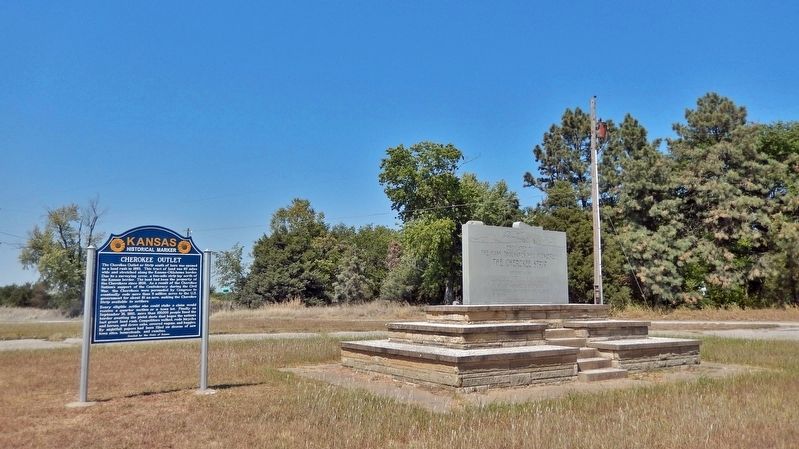
The Cherokee Outlet or Strip south of here was opened to a land rush in 1893. This tract of land was 60 miles wide and stretched along the Kansas-Oklahoma border. Due to a surveying error, a two-mile strip lay north of the Kansas border. The land had been the property of the Cherokees since 1836. As a result of the Cherokee Nation's support of the Confederacy during the Civil War, the Cherokees were persuaded by Congress to eventually cede more than 8 million acres to the U.S. government for about $1 an acre, making the Cherokee Strip available to settlers.
Every eligible settler who could stake a claim would receive a quarter section or a town lot. Finally on September 16, 1893, more than 100,000 people lined the border awaiting the pistol shots that began the nation's last great land rush. Competitors walked, rode bicycles and horses, and drove cabs, covered wagons, and buggies. By nightfall papers had been filed on dozens of new town sites, homesteads, and ranches.
Erected 2012 by Kansas Historical Society. (Marker Number 60.)
Topics and series. This historical marker is listed in these topic lists: Indigenous Peoples and Communities
this page online
Location. 37° 1.627′ N, 97° 2.888′ W. Marker is in Arkansas City, Kansas, in Cowley County. It can be reached from U.S. 77 near 312th Road, on the right when traveling south. The marker is located in a wayside on the west side of US Highway 77. Touch for map. Marker is at or near this postal address: 6532 312th Rd, Arkansas City KS 67005, United States of America. Touch for directions.

Regionally, this marker is in Eastern Kansas and in Greater Wichita. It is also in the American Midwest, in the Corn Belt, on the prairies, and on the Southern Plains. Globally, it is in North America, the Western Hemisphere, the Western World, and the Anglosphere. Historically, it finds itself in what was once New Spain and also the Louisiana Purchase.
Other nearby markers. At least 8 other markers are within 3 miles of this marker, measured as the crow flies: The Cherokee Strip (a few steps from this marker); a different marker also named The Cherokee Strip (approx. 2 miles away in Oklahoma);
Photographed by Cosmos Mariner, September 9, 2024
2. Cherokee Outlet Marker
Looking west through the wayside; a related "Cherokee Strip" historical marker is on the right.
Related markers. Click here for a list of markers that are related to this marker.
Also see . . .
1. Cherokee Outlet (Wikipedia).
Excerpt: The Cherokee Outlet, or Cherokee Strip, was located in what is now the state of Oklahoma in the United States. In 1889, Congress authorized the Cherokee Commission to persuade the Cherokee to cede their complete title to the Cherokee Outlet. After a great amount of pressure, and confirmed by a treaty Congress approved March 17, 1893, the Cherokee agreed, for "the sum of $8,595,736.12, over and above all other sums" to turn title over to the United States government. On September 16, 1893, the eastern end of the Cherokee Outlet was settled in the Cherokee Strip land run, the largest land run in the United States(Submitted on October 11, 2024, by Cosmos Mariner of Cape Canaveral, Florida.)and possibly the largest event of its kind in history.Photographed by Jeff Leichsenring, July 2, 20263. Cherokee Outlet Marker

2. Gateways to the Promised Land (by Jean C. Lough).
Excerpt: FOR A BRIEF WHILE, in 1893, southern Kansas was the focus of attention throughout the United States. Thousands of people flocked to the area. Correspondents for the great Eastern newspapers were present, sending out dozens of dispatches daily. The cause of this tremendous interest was the opening of the Cherokee strip, Indian territory, to settlement.(Submitted on October 11, 2024, by Cosmos Mariner of Cape Canaveral, Florida.)There were many reasons for this interest in the Cherokee outlet, or "strip," as it was called. Perhaps the greatest was that the land was forbidden. It had been supposed it would be the home of the Indian forever. Three railroads crossed it, but no settlement was permitted within it. The areas to the north and south were well populated. The homesteader wished to save the strip for civilization; he wished to break the power of the great cattlemen's combine, which, until 1890, had been using it. The railroads wished to see it settled, in order to increase their own profit.
Credits. This page was last revised on July 15, 2026. It was originally submitted on October 7, 2024, by Cosmos Mariner of Cape Canaveral, Florida. This page has been viewed 577 times since then and 109 times this year. Last updated on July 3, 2026, by Jeff Leichsenring of Garland, Texas. Photos: 1, 2. submitted on October 11, 2024, by Cosmos Mariner of Cape Canaveral, Florida. 3. submitted on July 3, 2026, by Jeff Leichsenring of Garland, Texas. • Devry Becker Jones was the editor who published this page.
