De Cocksdorp in Texel, North Holland, Netherlands — Northwestern Europe
De Cocksdorp - Kikkertstraat 59, Polderhuis

Photographed by Andrew Ruppenstein, June 1, 2026
1. De Cocksdorp - Kikkertstraat 59, Polderhuis Marker
Note that: 1) The small text in the upper left is repeated on all 12+ similar markers in De Cocksdorp as it is, effectively, the origin story of the area, and 2) the QR code and URL provided on the marker seemingly do not work.

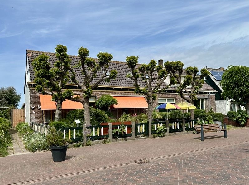
De inpoldering van Eierland (3300 ha.) in 1835 maakte Texel qua oppervlakte 1/6 deel groter. Texel bestond naast het oude land uit veel kleine poldertjes met aan het hoofd een dijkgraaf. Eierland was dermate groot dat het een dijkgraaf met secretariaat en eigen bestuur kreeg. Evenals dat er in Den Burg aan de Vismarkt een Polderhuis was, werd ook in De Cocksdorp Kikkertstraat 59 als Polderhuis bestempeld.
De polder Eierland is in 1835 ontstaan na bedijking van het Buitenveld, een kwelder oostelijk gelegen van de Zanddijk.
Deze stuifdijk werd ca. 1630 met gebruik van gevlochten matten van rijshout aangelegd tussen de duinen van de Koog en het voormalig eilandje Eyerland.
Deze zanddijk en de polder boven de Ruigendijk bepaalden de vorm van Texel.
De Cocksdorp – Kikkertstraat 59, Polder House
The reclamation of Eierland (3,300 hectares) in 1835 increased Texel's surface area by one-sixth. In addition to the original land, Texel consisted of many small polders, each headed by a dike reeve. Eierland was so large that it was assigned
this page online
The Eierland polder was created in 1835 following the diking of the Buitenveld, a salt marsh located east of the Zanddijk.
This drift-sand dike was constructed around 1630—using woven brushwood mats—between the dunes of De Koog and the former small island of Eyerland.
This sand dike and the polder above the Ruigendijk determined the shape of Texel.
Topics. This historical marker is listed in this topic list: Man-Made Features. A significant historical year for this entry is 1835.
Location. 53° 9.44′ N, 4° 52.419′ E. Marker is in De Cocksdorp, Noord-Holland (North Holland), in Texel. It is on Kikkertstraat, on the left when traveling east. Touch for map. Marker is at or near this postal address: Kikkertstraat 59, De Cocksdorp, Noord-Holland 1795 AB, Netherlands. Touch for directions.

Regionally, this marker is on the German Wadden Sea. Globally, it is in Europe, the European Union, Atlantic Europe, the Benelux Low Countries,
Photographed by Andrew Ruppenstein, June 1, 2026
2. De Cocksdorp - Kikkertstraat 59, Polderhuis and marker
The marker is visible here in the front garden, on the left.
Other nearby markers. At least 8 other markers are within walking distance of this marker: De Posthoorn / The Post Horn (within shouting distance of this marker); Stengweg (within shouting distance of this marker); De Cocksdorp - Kikkerstraat 47 (within shouting distance of this marker); De Strekdam / The Breakwater (within shouting distance of this marker); De Cocksdorp openbare lagere school / De Cocksdorp Public Primary School (about 90 meters away, measured in a direct line); De Gele Buurt / The “Yellow Neighborhood” (about 90 meters away); De Waddenkerk / The Wadden Church (about 120 meters away); De Cocksdorp - Kikkertstraat 17, BnB De Moerbei (about 180 meters away). Touch for a list and map of all markers in De Cocksdorp.
Credits. This page was last revised on July 8, 2026. It was originally submitted on July 8, 2026, by Andrew Ruppenstein of Lamorinda, California. This page has been viewed 20 times since then. Photos: 1, 2. submitted on July 8, 2026, by Andrew Ruppenstein of Lamorinda, California.
