Felixstowe in Suffolk, England, United Kingdom — Northwestern Europe (the British Isles)
Felixstowe Seafront Gardens
Heritage Trail - Ivy Terrace and Hamilton Gardens
Photographed by Ray Gurganus, April 21, 2026
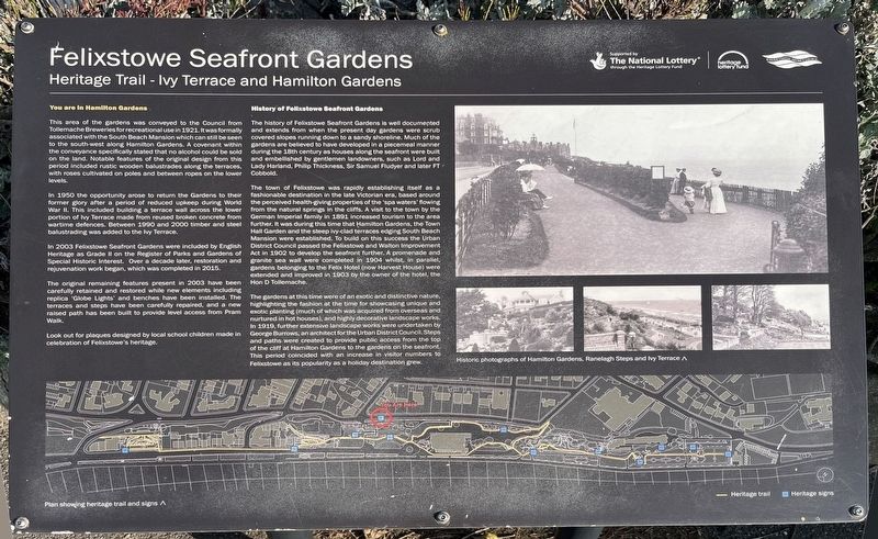
1. Felixstowe Seafront Gardens Marker
You are in Hamilton Gardens
This area of the gardens was conveyed to the Council from Tollemache Breweries for recreational use in 1921. It was formally associated with the South Beach Mansion which can still be seen to the south-west along Hamilton Gardens. A covenant within the conveyance specifically stated that no alcohol could be sold on the land. Notable features of the original design from this period included rustic wooden balustrades along the terraces, with roses cultivated on poles and between ropes on the lower levels.
In 1950 the opportunity arose to return the Gardens to their former glory after a period of reduced upkeep during World War II. This included building a terrace wall across the lower portion of Ivy Terrace made from reused broken concrete from wartime defences. Between 1990 and 2000 timber and steel balustrading was added to the Terrace.
In 2003 Felixstowe Seafront Gardens were included by English Heritage as Grade II on the Register of Parks and Gardens of Special Historic Interest. Over a decade later, restoration and rejuvenation work began, which was completed in 2015.
The original
this page online
History of Felixstowe Seafront Gardens
The history of Felixstowe Seafront Gardens is well documented and extends from when the present day gardens were scrub covered slopes running down to a sandy shoreline. Much of the gardens are believed to have developed in a piecemeal manner during the 18th century as houses along the seafront were built and embellished by gentlemen landowners, such as Lord and Lady Harland, Philip Thickness, Sir Samuel Fludyer and later FT Cobbold.
The town of Felixstowe was rapidly establishing itself as a fashionable destination in the late Victorian era, based around the perceived health giving properties of the spa water flowing from the natural springs in the cliffs. A visit to the town by the German Imperial family in 1891 increased tourism to the area further. It was during this time that Hamilton Gardens, the Town Hall Garden and the steep ivy-clad terraces edging South Beach Mansion were established. To build on this success the Urban District Council passed the Felixstowe and Walton Improvement Act in 1902 to develop the seafront further. A promenade and granite sea wall were completed in 1904 whilst in parallel gardens belonging to the Felix Hotel (now Harvest House) were extended and improved in 1903 by the owner of the hotel, the Hon D. Tollemache.
The gardens at this time were of an exotic and distinctive nature highlighting the fashion at the time for showcasing unique and exotic planting (much of which was acquired from overseas and nurtured in hot houses), and highly decorative landscape works. In 1919, further extensive landscape works were undertaken by George Burrows, an architect for the Urban District Council. Steps and paths were created to provide public access from the top of the cliff at Hamilton Gardens to the gardens on the seafront. This period coincided with an increase in visitor numbers to Felixstowe as its popularity as a holiday destination grew.
Topics. This historical marker is listed in this topic list: Parks & Recreational Areas.
Location. 51° 57.65′ N, 1° 21.175′ E. Marker is in Felixstowe, England, in Suffolk. It can be reached from Hamilton Gardens, on the left when traveling west. Touch for map. Marker is at or near this postal address: 4 Hamilton Gardens, Felixstowe, England IP11 7DE, United Kingdom. Touch for directions.

Regionally, this marker is in East Anglia. Globally, it is on the Atlantic Ocean, in the North Atlantic Region, in Europe, in Atlantic Europe, on one of the British Isles, in the Western World, and in the Anglosphere. Historically, it finds itself in what was once the Roman Empire.
Other nearby markers. At least 8 other markers are within 18 kilometers of this marker, measured as the crow flies: Nautical Almanac (approx. 0.3 kilometers away); The Deben Valley (approx. 14.6 kilometers away); Thomas Seckford (approx. 15 kilometers away); Isaac Johnson (approx. 15 kilometers away); Woodbridge (approx. 15.1 kilometers away); Ipswich Blackfriars (approx. 17 kilometers away); Ipswich Almshouses (approx. 17 kilometers away); Dr. Kurt Erich Glauber (approx. 17.2 kilometers away).
Credits. This page was last revised on July 9, 2026. It was originally submitted on July 9, 2026, by Ray Gurganus of Washington, District of Columbia. This page has been viewed 13 times since then. Photo 1. submitted on July 9, 2026, by Ray Gurganus of Washington, District of Columbia. • Andrew Ruppenstein was the editor who published this page.
Editor’s want-list for this marker. photo of the marker within its surroundings • Can you help?
