De Cocksdorp in Texel, North Holland, Netherlands — Northwestern Europe
Zanddijk
Photographed by Andrew Ruppenstein, June 1, 2026
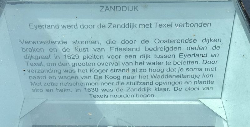
1. Zanddijk Marker

Eyerland was connected to Texel by the Zanddijk (“Sand Dike”). Devastating storms—which breached the dikes at Oosterend and threatened the coast of Friesland—prompted the dike reeve to advocate in 1629 for a dike between Eyerland and Texel to prevent the massive inrush of water. Due to silting, the beach at De Koog had already risen to such a level that it was sometimes possible to travel by horse and cart from De Koog to the small Wadden island. Reed screens were erected to trap drifting sand, and straw and marram grass were planted. The Zanddijk was completed
this page online
Erected 2016.
Topics. This historical marker is listed in this topic list: Man-Made Features. A significant historical year for this entry is 1629.
Location. 53° 9.322′ N, 4° 52.236′ E. Marker is in De Cocksdorp, Noord-Holland (North Holland), in Texel. It is on Kikkertstraat, on the right when traveling east. Touch for map. Marker is at or near this postal address: Kikkertstraat 6E, De Cocksdorp, Noord-Holland 1795 AD, Netherlands. Touch for directions.

Regionally, this marker is on the German Wadden Sea. Globally, it is in Europe, the European Union, Atlantic Europe, the Benelux Low Countries, the Schengen Area, Western Europe, and the Western World. Historically, it finds itself in what was once the Holy Roman Empire.
Other nearby markers. At least 8 other markers are within walking distance of this marker: De Gemeente school / The Municipal School (here, next to this marker); De Niuewe Aanleg (within shouting distance of this marker); Vuurtoren / Lighthouse (within shouting distance of this marker); De Cocksdorp (within shouting

Photographed by Andrew Ruppenstein, June 1, 2026
2. Zanddijk Marker - wide view
Below the text is an outline of present-day Texel. Within that outline, the white portions represent the “old” Texel (the south part, pre-Zanddijk), and the island of Eyerland (the north part). The Zanddijk is represented by a line running North-South between the two, on the west (left).

Photographed by Andrew Ruppenstein, June 1, 2026
3. Zanddijk Marker - wider view
This is one of eight subterranean historical markers set into the sidewalk on the south side of Kikkertstraat.
Credits. This page was last revised on July 10, 2026. It was originally submitted on July 10, 2026, by Andrew Ruppenstein of Lamorinda, California. This page has been viewed 13 times since then. Photos: 1, 2, 3. submitted on July 10, 2026, by Andrew Ruppenstein of Lamorinda, California.
