
Lawford in Essex, England, United Kingdom — Northwestern Europe (the British Isles)
Manningtree
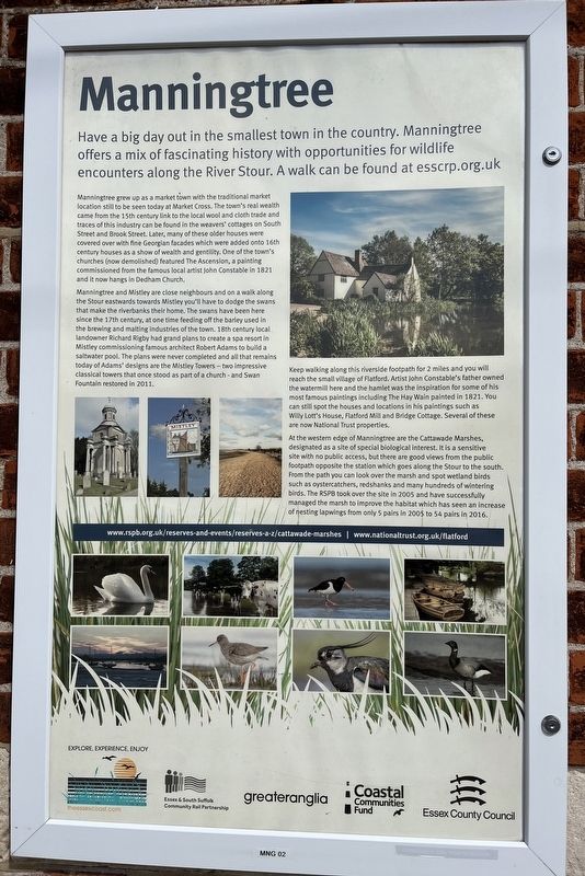
Photographed by Ray Gurganus, April 21, 2026
1. Manningtree Marker
Manningtree grew up as a market town with the traditional market location still to be seen today at Market Cross. The town's real wealth came from the 15th century link to the local wool and cloth trade and traces of this industry can be found in the weavers' cottages on South Street and Brook Street. Later, many of these older houses were covered over with fine Georgian facades which were added onto 16th century houses as a show of wealth and gentility. One of the town's churches (now demolished) featured The Ascension, a painting commissioned from the famous local artist John Constable in 1821 and it now hangs in Dedham Church.
Manningtree and Mistley are close neighbours and on a walk along the Stour eastwards towards Mistley you'll have to dodge the swans that make the riverbanks their home. The swans have been here since the 17th century, at one time feeding off the barley used in the brewing and malting industries of the town. 18th century local Landowner Richard Rigby had grand plans to create a spa resort in Mistley commissioning famous architect Robert Adams to build a saltwater pool. The plans were never completed and all that remains today of Adams' designs are the Mistley Towers-two impressive classical towers that once stood as part of a church and Swan Fountain restored in 2011.
Keep walking along this riverside footpath for 2 miles and you will reach the small village of Flatford. Artist John Constable's father owned the watermill here and the hamlet was the inspiration for some of his most famous paintings including The Hay Wain painted in 1821. You can still spot the houses and
this page online
At the western edge of Manningtree are the Cattawade Marshes. designated as a site of special biological interest. It is a sensitive site with no public access, but there are good views from the public footpath opposite the station which goes along the Stour to the south. From the path you can look over the marsh and spot wetland birds such as oystercatchers, redshanks and many hundreds of wintering birds. The RSPB took over the site in 2005 and have successfully managed the marsh to improve the habitat which has seen an increase of nesting lapwings from only 5 pairs in 2005 to 54 pairs in 2016.
Erected by Greater Anglia.
Topics. This historical marker is listed in these topic lists: Arts, Letters, Music • Environment. A significant historical year for this entry is 1821.
Location. 51° 56.938′ N, 1° 2.673′ E. Marker is in Lawford, England, in Essex. It is on Station Access Road, on the right when traveling west. Touch for map. Marker is at or near this postal address: Station Access Road, Lawford, England CO11 2LH, United Kingdom. Touch for directions.

Regionally, this marker is in the Greater South East. Globally, it is on the Atlantic Ocean, in the North Atlantic Region, in Europe, in Atlantic Europe, on one of the British Isles, in the Western World, and in the Anglosphere. Historically, it finds itself in what was once the Roman Empire.
Other nearby markers. At least 8 other markers are within 13 kilometers of this marker, measured as the crow flies: Walk in Constables Footsteps (within shouting distance of this marker); Manningtree, Mistley, and Lawford (approx. 1.2 kilometers away); Mistley Towers (approx. 2.3 kilometers away); Mistley Cobble Wall (approx. 2.4 kilometers away); Priory Street Bastion 5 (approx. 11.8 kilometers away); St Botolph's Priory (approx. 11.8 kilometers away); a different marker also named St Botolph's Priory (approx. 11.8 kilometers away); St Botolph's Churchyard (approx. 11.8 kilometers away). Touch for a list and map of all markers in Lawford.
Credits. This page was last revised on July 10, 2026. It was originally submitted on July 10, 2026, by Ray Gurganus of Washington, District of Columbia. This page has been viewed 8 times since then. Photo 1. submitted on July 10, 2026, by Ray Gurganus of Washington, District of Columbia. • Andrew Ruppenstein was the editor who published this page.
