De Cocksdorp in Texel, North Holland, Netherlands — Northwestern Europe
De Cocksdorp
Photographed by Andrew Ruppenstein, June 1, 2026
1. De Cocksdorp Marker

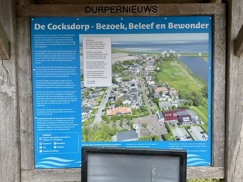
De Cocksdorp is het het jongste en meest noordelijke dorp van Texel. In eerst instantie heette het dorp Nieuwdorp maar het werd al spoedig vernoemd naar de Antwerpse reder Nicolas De Cock die het gebied tussen het voormalige eiland Eijerland en het oorspronkelijke eiland Texel in 1835 heeft ingepolderd.
De nieuwe polder wordt van het oude land gescheiden door de Ruigendijk, de oude zeedijk rond De Koog, Texelaars van 'achter de Rugediek' zijn anders volgens de bewoners van het oude Texelse land: vrijbuiters die nauw zijn verbonden met de natuur en niet zoveel op hebben met gezag en regeltjes...
Over de Postweg die in de nieuwe polder is aangelegd, werd tot 1927 de post voor Vlieland vervoerd. Al in de 17° eeu was er een snelle postroute van Amsterdam naar Texel en Vlieland. De zendingen werden per boot vanaf het haventje van De Cocksdorp naar het buureiland gebracht.
Van daaruit gingen ze met paard en wagen naar het Posthuis, het postkantoorgebouw van het eiland. In de Kikkertstraat zijn meerder straatvitrines aangebracht met verhalen en maquettes over het dorp
this page online
Centraal in het dorp ligt een plein met schitterend uitzicht over de oude zeeslenk en natuurgebied De Roggesloot. Op het plein zelf is een waterspeelplaats gemaakt die het eiland Texel verbeeld. Aan de noordkant van het dorp staat het in oude glorie teruggebrachte gemaalhuisje en gaat de straat over naar een prachtige trap tot achter de waddendijk.
Eenmaal over de dijk, bij het haventje, is het wad te bewonderen vanaf de robuuste steiger die meer dan 50 meter het wad op rijkt.
Stichting Waterrijke Perspectieven De Cocksdorp zet zich sinds 2012 in om een bijdrage leveren aan de leefbaarheid, ontwikkeling en beleving van het meest noordelijke dorp van Texel. Met als thema om De Cocksdorp zichtbaar en tastbaar in verbinding te brengen met de omgeving, de historie en het omringende water.
(English translation:)
De Cocksdorp: Visit, Experience, and Admire
De Cocksdorp is the youngest and northernmost village on Texel. Initially named Nieuwdorp (“New Village”), it was soon renamed after Nicolas De Cock, a shipowner from Antwerp who reclaimed the
Photographed by Andrew Ruppenstein, June 1, 2026
2. De Cocksdorp Marker
The new polder is separated from the older land by the Ruigendijk—the old sea dike surrounding De Koog. According to residents of the older part of Texel, the people living "behind the Ruigendijk" are different: free spirits with a close bond to nature who have little regard for authority or petty rules...
Until 1927, mail destined for Vlieland was transported along the Postweg, a road constructed within the new polder. A fast postal route connecting Amsterdam to Texel and Vlieland had already existed since the 17th century; shipments were ferried by boat from the small harbor at De Cocksdorp to the neighboring island.
From there, they traveled by horse and wagon to the Posthuis, the island’s post office building. Several street-side display cases have been installed along Kikkertstraat, featuring stories and scale models detailing the village and its history.
At the heart of the village lies a square offering a magnificent view of the old tidal channel and the De Roggesloot nature reserve. The square itself features a water play area designed
L. Bakker, courtesy Noord-Hollands Archief (Inventaris 40273), circa 1910
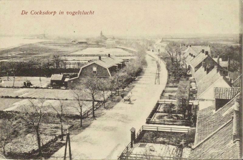
3. De Cocksdorp en vogelvlucht / Birds-eye view of De Cocksdorp
Looking west along Kikkertstraat (then Dorpstraat), with the Roman Catholic Church and De Hoop Windmill visible in the distance. Judging from the height and angle, this was almost certainly taken from the Waddenkerk church tower.
Once across the dike and near the small harbor, visitors can admire the mudflats from a sturdy jetty that extends more than 50 meters out over the tidal flats.
Since 2012, the Stichting Waterrijke Perspectieven De Cocksdorp (“Water-Rich Perspectives De Cocksdorp Foundation”) has been dedicated to enhancing the livability, development, and visitor experience of Texel’s northernmost village. Its mission is to create a visible and tangible connection between De Cocksdorp and its surroundings, its history, and the nearby water.
Topics. This historical marker is listed in these topic lists: Communications • Man-Made Features • Settlements & Settlers. A significant historical year for this entry is 1835.
Location. 53° 9.303′ N, 4° 52.188′ E. Marker is in De Cocksdorp, Noord-Holland (North Holland), in Texel. It is at the intersection of Klimpstraat and Kikkertstraat, on the right when traveling north on Klimpstraat. Touch for map. Marker is at or near this postal address: Klimpstraat 2, De Cocksdorp, Noord-Holland 1795 AL, Netherlands. Touch for directions.

Regionally, this marker is on the German Wadden Sea. Globally, it is in Europe, the European Union, Atlantic Europe, the Benelux Low Countries, the Schengen Area, Western Europe, and the Western World. Historically, it finds itself in what was once the Holy Roman Empire.
Other nearby markers. At least 8 other markers are within walking distance of this marker: Vuurtoren / Lighthouse (within shouting distance of this marker); RK kerk / Roman Catholic Church (within shouting distance of this marker); Molenbos (within shouting distance of this marker); De Niuewe Aanleg (within shouting distance of this marker); Zanddijk (within shouting distance of this marker); De Gemeente school / The Municipal School (within shouting distance of this marker); De Cocksdorp - Kikkertstraat 17, BnB De Moerbei (about 180 meters away, measured in a direct line); De Gele Buurt / The “Yellow Neighborhood” (approx. 0.3 kilometers away). Touch for a list and map of all markers in De Cocksdorp.
Also see . . . De Cocksdorp (Wikipedia). Excerpt:
De Cocksdorp is a road village which developed on the north of island shortly after the poldering of Eierland in 1835. In 1836, it was named after Nicolas Joseph de Cock after the main merchant who initiated the poldering. The village was built around a harbour.(Submitted on July 11, 2026.)
Credits. This page was last revised on July 11, 2026. It was originally submitted on July 10, 2026, by Andrew Ruppenstein of Lamorinda, California. This page has been viewed 11 times since then. Photos: 1. submitted on July 10, 2026, by Andrew Ruppenstein of Lamorinda, California. 2, 3. submitted on July 11, 2026, by Andrew Ruppenstein of Lamorinda, California.
