
Den Hoorn Texel in Texel, North Holland, Netherlands — Northwestern Europe
Haven ‘t Horntje
⎯⎯⎯
‘t Horntje Harbor

Photographed by Andrew Ruppenstein, June 1, 2026
1. Haven ‘t Horntje / ‘t Horntje Harbor Marker - all five panels
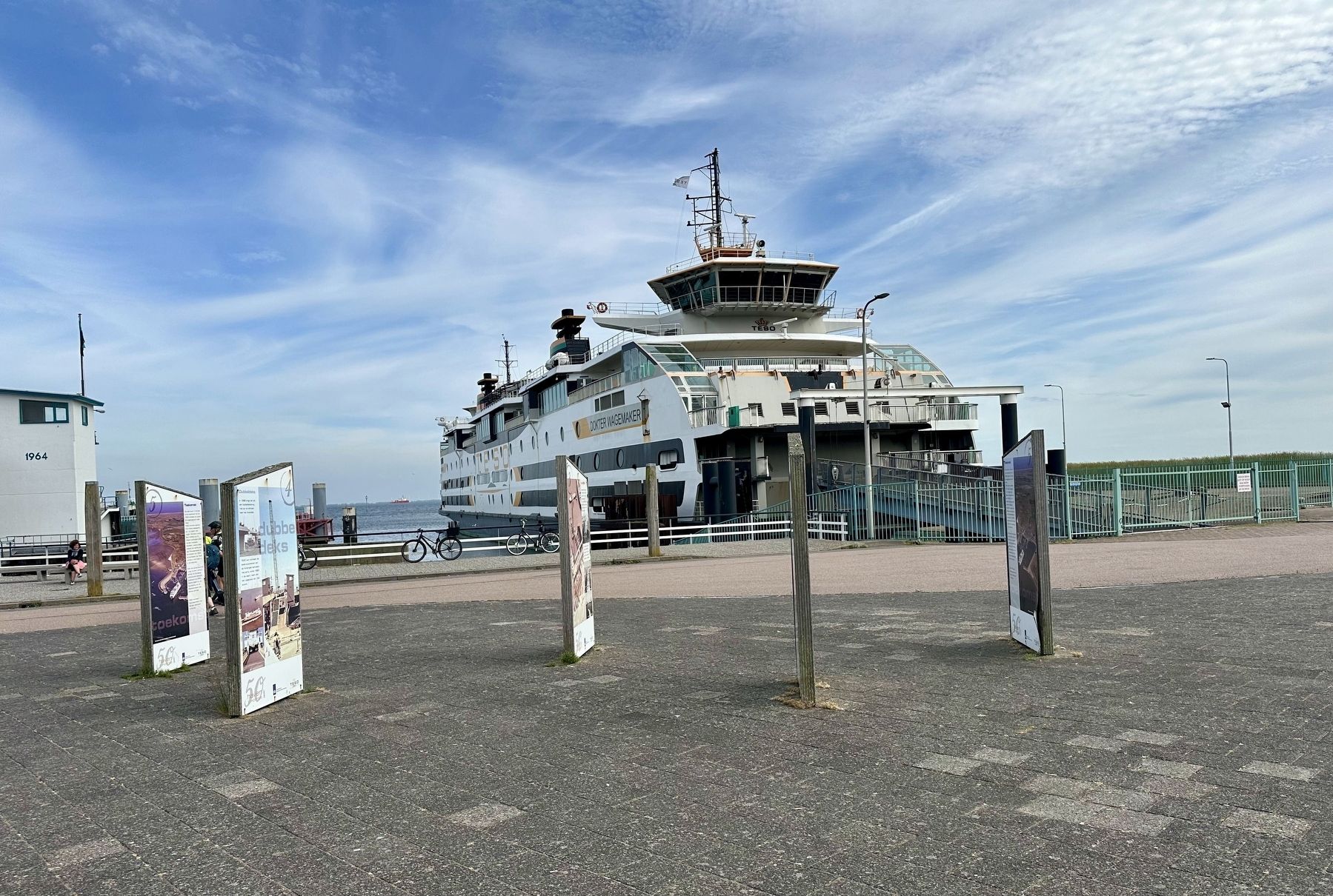
The panels are situated just a short distance from the ferry docks.

Voor 1962
Sinds de oprichting van TESO in 1907 is Oudeschild de thuishaven. Mede onder druk van de toename van het autoverkeer naar Texel neemt Rijkswaterstaat in 1958 een besluit: er komt een nieuwe veerhaven bij 't Horntje. Tot juni 1962 zullen de schepen van TESO nog de haven van Oudeschild binnenvaren. In april 1961 worden de havenwerken aanbesteed. Hieronder de nog ongerepte duinen op de plek waar de nieuwe veerhaven zal komen.
De aanleg
In 1961 starten de werkzaamheden voor de aanleg van de nieuwe veerhaven. Op 8 juni 1962 neemt TESO de nieuwe haven op 't Horntje officieel in gebruik. De aanlegplaats is geschikt voor schepen met belading via de zijkant.
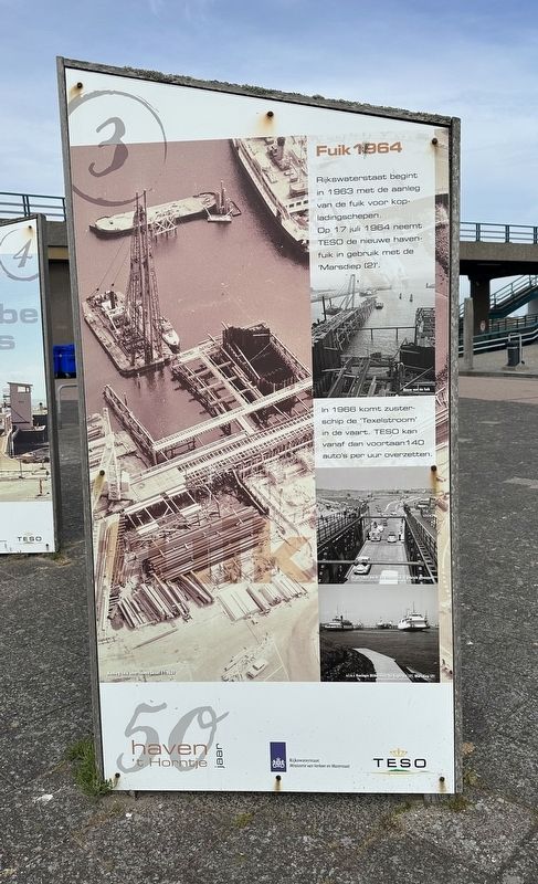
Fuik 1964
Rijkswaterstaat begint in 1963 met de aanleg van de fuik voor kopladingschepen. Op 17 juli 1964 neemt TESO de nieuwe havenfuik in gebruik met de 'Marsdiep (2)'. In 1966 komt zusterschip de 'Texelstroom' in de vaart. TESO kan vanaf dan voortaan 140 auto's per uur overzetten.
Dubbeldeks
In 1986 krijgt de fuik een dubbeldeksbrug met op- en afritten naar het bovendek. TESO kan voortaan de beide autodekken van de 'Molengat' benutten. Het schip, sinds 1980 in de vaart, heeft dan een capaciteit van 190 auto's.
Toekomst
De veerhaven 't Horntje is de thuishaven van de TESO schepen en vormt de toegangspoort naar Texel. TESO vervoert jaarlijks 3,5 miljoen passagiers en 1,4 miljoen voertuigen. Verwacht wordt dat in 2040 ruim 2 miljoen voertuigen zullen worden overgezet. Aantallen, waaruit blijkt hoezeer de veerhavens van Rijkswaterstaat en de schepen van TESO de levensader van Texel vormen in het heden en in de toekomst.
Met oog op de toekomst is een verdere verduurzaming van de dienstverlening een belangrijk speerpunt van TESO. Daarbij staat ook verduurzaming van de Rijkswaterstaat veerhavens centraal.
TESO feliciteert Rijkswaterstaat met 50 jaar veerhaven 't Horntje.
’t Horntje Harbor - 50 Years
Before 1962
Oudeschild has been TESO’s home port since the company was founded in 1907. Partly due to the increase in car traffic to Texel, Rijkswaterstaat (the Dutch Directorate-General for Public Works and Water Management) made a decision in 1958: a new ferry terminal would be built at 't Horntje. TESO’s ships continued to use the port of Oudeschild until June 1962. Contracts for the harbor construction works were awarded in April 1961. Shown below are the still-pristine dunes at the site where the new ferry terminal would be built.
Construction
Construction work on the new ferry terminal began in 1961. On June 8, 1962, TESO officially began using the new terminal at 't Horntje. The berth was designed for ships that were loaded from the side.
Loading ramp (1964)
In 1963, Rijkswaterstaat began constructing a loading ramp for bow-loading ships. On July 17, 1964, TESO put the new ramp into service with the Marsdiep (2). Its sister ship, the Texelstroom, entered service in 1966. From that point on, TESO was able to transport 140 cars per hour.
Double-deck
In 1986, the loading ramp was fitted with a double-deck bridge featuring ramps leading to the upper deck. This allowed TESO to utilize both car decks of the Molengat. The ship, which had been in service since 1980, had a capacity of 190 cars.
The Future
The 't Horntje ferry terminal is the home port for TESO’s vessels and serves as the gateway to Texel. TESO transports 3.5 million passengers and 1.4 million vehicles annually. By 2040, the number of vehicles transported is expected to exceed 2 million. These figures demonstrate just how vital Rijkswaterstaat’s ferry terminals and TESO’s vessels are as a lifeline for Texel—both now and in the future.
With an eye on the future, making operations more sustainable is a key priority for TESO. Making Rijkswaterstaat’s ferry terminals more sustainable is also central to this effort.
TESO congratulates Rijkswaterstaat on the 50th anniversary of the 't Horntje ferry terminal.
Erected 2012
this page online
Topics. This historical marker is listed in this topic list: Waterways & Vessels. A significant historical date for this entry is June 8, 1962.
Location. 53° 0.233′ N, 4° 46.81′ E. Marker is in Den Hoorn Texel, Noord-Holland (North Holland), in Texel. It is on Pontweg. Touch for map. Marker is at or near this postal address: Pontweg 1, Den Hoorn Texel, Noord-Holland 1797 SN, Netherlands. Touch for directions.

Regionally, it is in Europe, the European Union, Atlantic Europe, the Benelux Low Countries, the Schengen Area, Western Europe, and the Western World. Historically, it finds itself in what was once the Roman Empire and specifically also the Holy Roman Empire.
Other nearby markers. At least 8 other markers are within 6 kilometers of this marker, measured as the crow flies: Rampspoed in het verleden / Disaster in the Past (about 210 meters away, measured in a direct line); Beaufighter NE746 Crash Memorial (approx. 2.3 kilometers away); Huis aan zee / House by the sea (approx. 4.7 kilometers away); RAF North Coates Strike Wing Memorial (Vliegers Monument) (approx. 4.8 kilometers away); Leo Pinkhof

Photographed by Andrew Ruppenstein, June 1, 2026
2. Haven ‘t Horntje / ‘t Horntje Harbor Marker - panel one

Photographed by Andrew Ruppenstein, June 1, 2026
3. Haven ‘t Horntje / ‘t Horntje Harbor Marker - panel two
Photographed by Andrew Ruppenstein, June 1, 2026
4. Haven ‘t Horntje / ‘t Horntje Harbor Marker - panel three

Photographed by Andrew Ruppenstein, June 1, 2026
5. Haven ‘t Horntje / ‘t Horntje Harbor Marker - panel 4

Photographed by Andrew Ruppenstein, June 1, 2026
6. Haven ‘t Horntje / ‘t Horntje Harbor Marker - panel five
Photographed by Andrew Ruppenstein, June 1, 2026
7. Haven ‘t Horntje / ‘t Horntje Harbor Marker and TESO ferry Dokter Wagemaker
Credits. This page was last revised on July 12, 2026. It was originally submitted on July 12, 2026, by Andrew Ruppenstein of Lamorinda, California. This page has been viewed 2 times since then. Photos: 1, 2, 3, 4, 5, 6, 7. submitted on July 12, 2026, by Andrew Ruppenstein of Lamorinda, California.
