Near Topton in Cherokee County, North Carolina — The American South (South Atlantic)
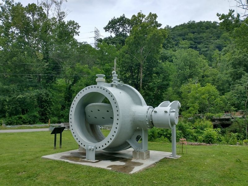
The Turbine Inlet Valve

Photographed by Tom Bosse, July 12, 2026
1. The Turbine Inlet Valve Marker
The monument you see here is the Nantahala Power Plant's turbine inlet valve, a safety device that allows the shut-off of water running through the unit. It is dedicated to the memory of all those who helped bring power to the Nantahala region.
In 2022, the plant replaced this important valve to ensure continued safe operations.
History of Nantahala Power Plant
Starting in 1910, Aluminum Company of America (Alcoa) acquired land in North Carolina to power its smelting plant in Alcoa, Tenn. Alcoa formed a subsidiary in 1929 called Nantahala Power & Light Company (NP&L) to serve as a public utility for the Great Smoky Mountains area of North Carolina.
Construction on the Nantahala dam, penstock and powerhouse began in the 1920s by Alcoa, but completion was suspended due to the Depression. Construction resumed in 1940 to help support power needed to produce the sheet metal used in WWII fighter aircraft.
In 1942, construction was complete and the 251-foot-tall rock-fill, sloping earth core dam held water that enters the 5.6-mile-long penstock through the mountains to the powerhouse.
What is Hydropower?
Conventional
this page online
How Do Conventional Hydro Plants Work?
Reservoir
The water is held in a reservoir, or lake, behind the dam.
Penstock
Penstocks lead the water in a chamber housing the turbine. The water is held at a higher elevation than the turbine so that it can fall with enough force to strike the turbine's blades and cause it to spin.
Turbine
The turbine wheel is attached by a shaft to a system of magnets and wires called a generator. As the turbine rotates, these magnets and wires also spin - producing electricity.
Draft tube and tailrace
The water returns to the river by passing through a draft tube under the turbine and into the tailrace.
Erected by Duke Energy.
Topics. This historical marker is listed in these topic lists: Industry & Commerce • Man-Made Features. A significant historical year for this entry is 2022.
Location. 35° 16.356′ N, 83° 40.671′ W. Marker is near Topton, North Carolina, in Cherokee County. It is on Wayah Road, on the right when traveling east. Touch for map.

Photographed by Tom Bosse, July 12, 2026
2. The Turbine Inlet Valve Marker

Regionally, this marker is in North Carolina’s Mountains. It is also in the American South, specifically in the Upper South, in Appalachia, and specifically in Southern Appalachia. Globally, it is in North America, the Western Hemisphere, the Western World, and the Anglosphere. Historically, it finds itself in what was once the original Cherokee Nation, the territory of the Mississippian Culture, one of the original Thirteen Colonies, one of the Confederate States of America, and the Antebellum South.
Other nearby markers. At least 8 other markers are within 8 miles of this marker, measured as the crow flies: A Glimpse Into Nantahala's Past (approx. 0.2 miles away); William Bartram (approx. 0.4 miles away); Nantahala Town (approx. 2½ miles away); Nantahala Community and Lake (approx. 5.7 miles away); Civil War in Graham County (approx. 8.1 miles away); Junaluska (approx. 8.1 miles away); Junaluska and The Battle of Horseshoe Bend (approx. 8.1 miles away); 1819 Treaty with the United States (approx. 8.1 miles away).

Photographed by Tom Bosse, July 12, 2026
3. The Turbine Inlet Valve
Photographed by Tom Bosse, July 12, 2026
4. The Turbine Inlet Valve
Credits. This page was last revised on August 4, 2026. It was originally submitted on July 13, 2026, by Tom Bosse of Jefferson City, Tennessee. This page has been viewed 21 times since then. Photos: 1, 2, 3, 4. submitted on July 13, 2026, by Tom Bosse of Jefferson City, Tennessee. • Andrew Ruppenstein was the editor who published this page.
