Glass Point in Jamestown in James City County, Virginia — The American South (Mid-Atlantic)
Original Glasshouse, 1608

Photographed by Tracy Andersen Roberts, July 3, 2026
1. Original Glasshouse, 1608 Marker
The German artisans produced common green glass or Waldglas (forest glass). They most likely made window glass, bottles, vials or simple drinking glasses. This first industrial experiment lasted only one year, when the "Starving Time" and strained relations with the Powhatan Indians led to the abandonment of the glasshouse.
In 1948-1949, the National Park Service excavated this site. In addition to the furnaces and kiln, a refuse pit was uncovered that yielded fragments of old melting pots, a "glory hole" or working hole, cullet (old glass used to make new glass), and glass drippings.
(captions)
Glassblower, 1608 Sketch by Sidney King
Skilfull Workmen from Forraine Parts
Robert Johnson, Deputy Treasurer of the Virginia Company of London, 1609
Cullet or broken glass
Glasshouse features
Working furnace excavated in 1948-1949
Topics.
this page online
Location. 37° 13.248′ N, 76° 47.079′ W. Marker is in Jamestown, Virginia, in James City County. It is in Glass Point. It can be reached from Colonial National Historical Park 0.6 miles south of Jamestown Road (Virginia Route 31), on the right when traveling south. Touch for map. Marker is at or near this postal address: 1348 Colonial Nat'l Historical Pkwy, Jamestown VA 23081, United States of America. Touch for directions.

Regionally, this marker is on Virginia’s Peninsula, in Coastal Virginia, and in the Hampton Roads Metropolitan Area. It is also in the American South, specifically in the Upper South, in the Tidewater, and on the Eastern Seaboard. Globally, it is in the North Atlantic Region, North America, the Western Hemisphere, the Western World, and the Anglosphere. Historically, it finds itself in what was once the territory of the Mississippian Culture, one of the original Thirteen Colonies, one of the Confederate

Photographed by Tracy Andersen Roberts, July 3, 2026
2. marker shown in front of Glasshouse ruins enclosure
Other nearby markers. At least 8 other markers are within walking distance of this marker: Glasshouse Ruins (here, next to this marker); Interpreting the Glasshouse (a few steps from this marker); An Ancient Road (within shouting distance of this marker); The Glasshouse (within shouting distance of this marker); Glassmaking - 1608 (within shouting distance of this marker); Jamestown (about 700 feet away, measured in a direct line); Boatbuilding (about 800 feet away); Fishing (about 800 feet away). Touch for a list and map of all markers in Jamestown.
Also see . . . National Park Service entry, "Jamestown Glasshouse".
One of the first English attempts at industrialization and manufacturing in America was glassblowing.The Company hoped glass production might provide the profit that it was looking for. The New World abounded with raw materials -wood for fuel and ash, and sand (silica) for the glass. All that was needed were artisans and various laborers to produce the glass.(Submitted on July 18, 2026, by Tracy Andersen Roberts of Atlanta, Georgia.)
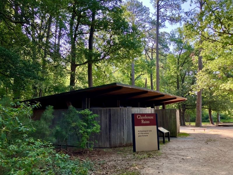
Photographed by Tracy Andersen Roberts, July 3, 2026
3. marker shown in front of full building enclosing the ruins
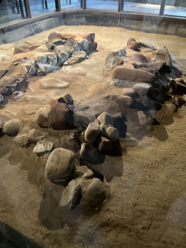
Photographed by Tracy Andersen Roberts, July 3, 2026
4. the ruins themselves
Credits. This page was last revised on September 1, 2026. It was originally submitted on July 18, 2026, by Tracy Andersen Roberts of Atlanta, Georgia. This page has been viewed 18 times since then. Photos: 1, 2, 3, 4. submitted on July 18, 2026, by Tracy Andersen Roberts of Atlanta, Georgia. • Bernard Fisher was the editor who published this page.
