Glass Point in Jamestown in James City County, Virginia — The American South (Mid-Atlantic)
The Glasshouse
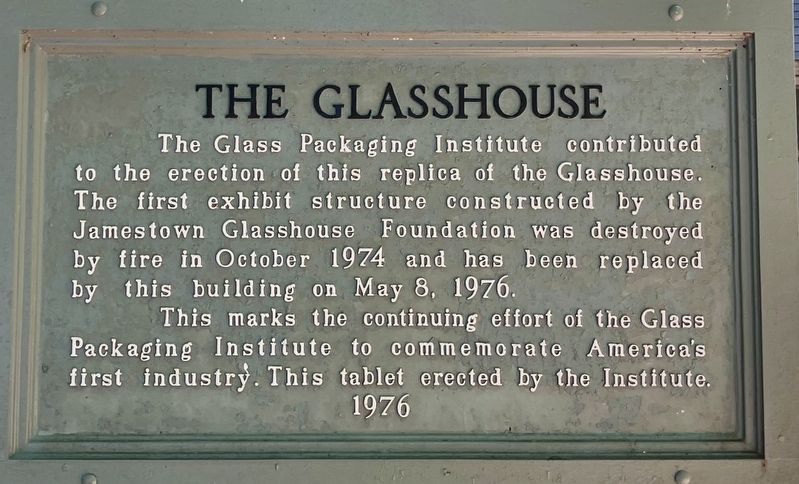
Photographed by Tracy Andersen Roberts, July 3, 2026
1. The Glasshouse Marker
Erected 1976 by Glass Packaging Institute.
Topics. This historical marker is listed in these topic lists: Anthropology & Archaeology • Industry & Commerce. A significant historical date for this entry is May 8, 1976.
Location. 37° 13.242′ N, 76° 47.129′ W. Marker is in Jamestown, Virginia, in James City County. It is in Glass Point. It can be reached from Colonial National Historical Parkway 0.6 miles south of Jamestown Road (Virginia Route 31), on the right when traveling south. Touch for map. Marker is in this post office area: Jamestown VA 23081, United States of America. Touch for directions.

Regionally, this marker is on Virginia’s Peninsula, in Coastal Virginia, and in the Hampton Roads Metropolitan Area.
this page online
Other nearby markers. At least 8 other markers are within walking distance of this marker: Glassmaking - 1608 (within shouting distance of this marker); Glasshouse Ruins (within shouting distance of this marker); Original Glasshouse, 1608 (within shouting distance of this marker); An Ancient Road (about 300 feet away, measured in a direct line); Interpreting the Glasshouse (about 300 feet away); Boatbuilding (about 600 feet away); Fishing (about 600 feet away); James Fort (about 700 feet away). Touch for a list and map of all markers in Jamestown.
Also see . . . National Park Service entry, "Jamestown Glasshouse".
At "glass point" near Jamestown, the glass furnaces were re-discovered(Submitted on July 18, 2026, by Tracy Andersen Roberts of Atlanta, Georgia.)and excavated in 1948. Today, in a reconstructed, interpretive facility, glassblowing is again performed at Jamestown. Modern artisans, in reproductive clothing, produce common glass objects very much as they must have done almost 400 years ago.Photographed by Tracy Andersen Roberts, July 3, 20262. marker shown in front of reconstructed, interpretive facility


Photographed by Tracy Andersen Roberts, July 3, 2026
3. looking back at the James River from the marker
Credits. This page was last revised on July 19, 2026. It was originally submitted on July 18, 2026, by Tracy Andersen Roberts of Atlanta, Georgia. This page has been viewed 18 times since then. Photos: 1, 2, 3. submitted on July 18, 2026, by Tracy Andersen Roberts of Atlanta, Georgia. • Bernard Fisher was the editor who published this page.
