Mount Evelyn in Yarra Ranges Shire, Victoria, Australia — Oceania
The First Train
| — | The Timeline Community Arts Project | — |
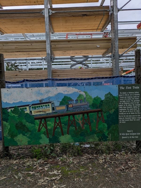
Photographed by Dean Barton-Ancliffe, June 18, 2026
1. THe First Train Marker
How the first train steams across the trestle bridge over Maroondah Highway to begin the climb towards Olinda Vale station (Mt Evelyn)
Painted by M Evelyn Special Development School
Sponsored by Ark Sheet Metal
Erected by Mt Evelyn Township Improvement Committee.
Topics. This historical marker is listed in these topic lists: Parks & Recreational Areas • Railroads & Streetcars. A significant historical year for this entry is 1901.
Location. 37° 47.16′ S, 145° 22.773′ E. Marker is in Mount Evelyn, Victoria, in Yarra Ranges Shire. It can be reached from Wray Crescent 0.1 kilometers north of York Road (Victoria Route C402). Touch for map. Marker is at or near this postal address: 26 York Road, Mount Evelyn VIC 3796,
this page online

Regionally, it is in Oceania, in Australasia, in the Pacific Ocean, in South Pacific, on the Pacific Rim, in the Western World, and in the Anglosphere. Historically, it finds itself in what was once a British colony.
Other nearby markers. At least 8 other markers are within walking distance of this marker: Swaggies in Tough Times (here, next to this marker); Peace after War (a few steps from this marker); The Berry Farm (a few steps from this marker); Scouts 80 Years in Mt Evelyn (a few steps from this marker); Bullock Teams and Timber (a few steps from this marker); The Aqueduct from Silvan (a few steps from this marker); The Wurrundjeri (within shouting distance of this marker); The Army Camp (within shouting distance of this marker). Touch for a list and map of all markers in Mount Evelyn.
Also see . . . Vic Rail Stations. Warburton Line
Opened to Warburton as a branch line from Lilydale in 1901, connecting to the Healesville Line. Its main purpose was for timber haulage from the forests in the Yarra Ranges as well as the movement of general freight and passengers to the many(Submitted on July 18, 2026, by Dean Barton-Ancliffe of Rowville, Victoria.)small townships along the line. Several timber tramways connected with the railway at the townships towards the Warburton end. Stations existed along this line at Mount Evelyn, Wandin, Seville, Killara, Woori Yallock, Launching Place, Yarra Junction, Wesburn, Millgrove and Warburton.Photographed by Dean Barton-Ancliffe, June 18, 20262. The First Train Marker along the Rail Trail
Trains operated on this line until 1965 when the decision was made to close the line. The track was dismantled in the 1970s and the bridge was removed over the Maroondah Highway in Lilydale. Most of the Right of Way for this train line has now been converted to a horse and bicycle train and is a very popular tourist route with great scenery. Parking areas exist at most of the former station sites and provide a great starting point for walks or rides. In addition to the Right of Way there is some further evidence of the existence of the former railway. Notable bridges remain across Forest Road in Mt Evelyn and across Scotchmans Creek Road in Warburton. There is a single section of remaining trackwork at the former level crossing at Highfield Road in Warburton. Evidence of platforms exist to varying degrees at some of the station sites with the station building and goods platform remaining at Yarra Junction for use as a railway museum.
There is however a missing section of this former rail line that is not available to the public. This is the section between Anderson St and the Maroondah Highway in Lilydale, due to a lease from the Mount Lilydale Mercy College. It is important that this section is eventually returned to the public to provide a continuous link from Lilydale Station, making the route accessible to people arriving on public transport. The school however is not willing to relinquish the lease, as they believe the adjacent trail would pose a safety risk for students. At this stage the State Government is not willing to confront the school on this issue. Moves are currently afoot to rebuild the Maroondah Highway bridge so the safety of trail users is improved and they are not confronted with crossing this busy road.

Credits. This page was last revised on July 24, 2026. It was originally submitted on July 18, 2026, by Dean Barton-Ancliffe of Rowville, Victoria. This page has been viewed 18 times since then. Photos: 1, 2. submitted on July 18, 2026, by Dean Barton-Ancliffe of Rowville, Victoria. • Andrew Ruppenstein was the editor who published this page.
