Den Helder, North Holland, Netherlands — Northwestern Europe
Waddenzee-graftekens
⎯⎯⎯
Waddenzee Gravestones
Photographed by Andrew Ruppenstein, June 2, 2026
1. Waddenzee-graftekens / Waddenzee Gravestones Marker

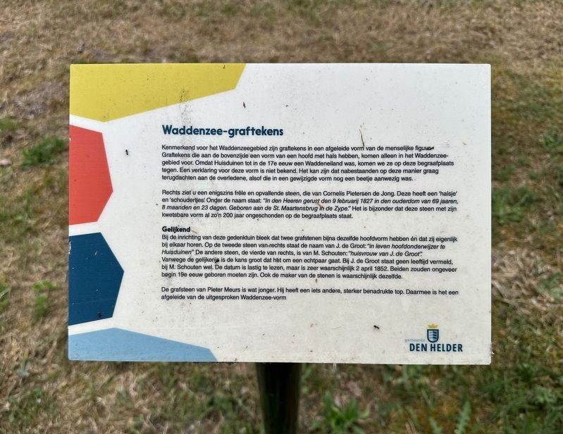
Kenmerkend voor het Waddenzeegebied zijn graftekens in een afgeleide vorm van de menselijke figuur Graftekens die aan de bovenzijde een vorm van een hoofd met hals hebben, komen alleen in het Waddenzeegebied voor. Omdat Huisduinen tot in de 17e eeuw een Waddeneiland was, komen we ze op deze begraafplaats tegen. Een verklaring voor deze vorm is niet bekend. Het kan zijn dat nabestaanden op deze manier graag terugdachten aan de overledene, alsof die in een gewijzigde vorm nog een beetje aanwezig was.
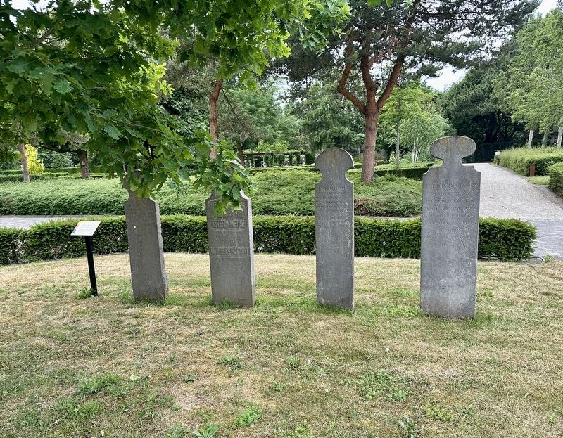
Rechts ziet u een enigszins frêle en opvallende steen, die van Cornelis Pietersen de Jong. Deze heeft een 'halsje' en 'schoudertjes: Onder de naam staat: "In den Heeren gerust den 9 februarij 1827 in den ouderdom van 69 jaaren, 8 maanden en 23 dagen. Geboren aan de St. Maartensbrug in de Zype.” Het is bijzonder dat deze steen met zijn kwetsbare vorm al zo'n 200 jaar ongeschonden op de begraafplaats staat.
Gelijkend
Bij de inrichting van deze gedenktuin bleek dat twee grafstenen bijna dezelfde hoofdvorm hebben én dat zij eigenlijk bij elkaar horen. Op de tweede steen van rechts staat de naam
this page online
De grafsteen van Pieter Meurs is wat jonger. Hij heeft een iets andere, sterker benadrukte top. Daarmee is het een afgeleide van de uitgesproken Waddenzee-vorm
Waddensea Gravestones
Characteristic of the Wadden Sea area are tombstones shaped in a derived form of the human figure. Grave markers that have a shape of a head with a neck at the top only occur in the Wadden Sea area. Because Huisduinen was a Wadden island until the 17th century, we come across them in this cemetery. An explanation for this shape is not known. It could be that surviving relatives liked to remember the deceased in this way, as if they were still somewhat present in
Photographed by Andrew Ruppenstein, June 2, 2026
2. Waddenzee-graftekens / Waddenzee Gravestones Marker - wide view
On the right, you can see a somewhat frail and striking stone, that of Cornelis Pietersen de Jong. This one has a "neck" and "shoulders". Under the name it says: "Rested in the Lord on February 9, 1827, at the age of 69 years, 8 months and 23 days. Born at the St. Maartensbrug in the Zype." It is remarkable that this stone, with its fragile shape, has stood undamaged in the cemetery for about 200 years.
Resemblances
During the design of this memorial garden, it turned out that two tombstones have almost the same head shape and that they actually belong together. On the second stone from the right is the name of J. de Groot: "in life head teacher at Huisduinen". The other stone, the fourth from the right, is of M. Schouten: "housewife of J. de Groot". Because of the resemblance, there is a high probability that this is a married couple. J. de Groot does not mention an age, but M. Schouten does. The date is difficult to read, but is most likely April 2, 1852. Both must have been born around the beginning of the 19th century. The maker of the stones is also probably the same.
The tombstone of Pieter Meurs is
Photographed by Andrew Ruppenstein, June 2, 2026
3. Waddenzee-graftekens / Waddenzee Gravestones Marker - wide view
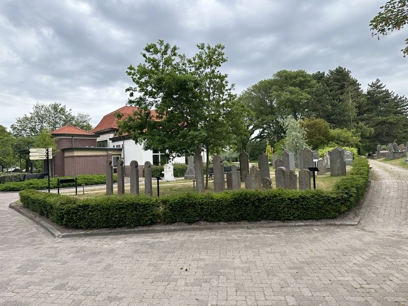
This view shows most of the sections of the historical memorial garden, taken from the rear of the garden, with the backs of the four Waddensee-type gravestones visible here in the foreground on the left. The historical memorial garden consists of roughly fifty gravestones distributed among several sections, with each section having a historical marker explaining the significance of the gravestones.
Erected by Gemeente Den Helder.
Topics. This historical marker is listed in this topic list: Cemeteries & Burial Sites. A significant historical date for this entry is April 2, 1852.
Location. 52° 57.06′ N, 4° 44.235′ E. Marker is in Den Helder, Noord-Holland (North Holland). It is on Kerkhoflaan. The marker is located in the Historical Memorial Garden Section of the Den Helder Algemene Begraafplaats. Touch for map. Marker is at or near this postal address: Kerkhoflaan 4, Den Helder, Noord-Holland 1783 AV, Netherlands. Touch for directions.

Regionally, it is in Europe, the European Union, Atlantic Europe, the Benelux Low Countries, the Schengen Area, Western Europe, and the Western World. Historically, it finds itself in what was once the Holy Roman Empire.
Other nearby markers. At least 8 other markers are within walking distance of this marker: Bijzonder oude graftekens / Exceptionally Old Grave Markers (here, next to this marker); Christelijke symboliek / Christian Symbolism (a few steps from this marker); Symboliek op grafstenen / Symbolism on Gravestones (a few steps from this marker); Soortens Graftekens… / Types of Grave Markers… (a few steps from this marker); Zeevaart, Post, Zeeredder / Navigation, Post, and Sea Rescuers (a few steps from this marker); Ambachtelijke vaardigheden / Craft Skills (a few steps from this marker); Materialen / Materials (within shouting distance of this marker); Historische gedenktuin / Historical Memorial Garden (within shouting distance of this marker). Touch for a list and map of all markers in Den Helder.
Credits. This page was last revised on July 19, 2026. It was originally submitted on July 19, 2026, by Andrew Ruppenstein of Lamorinda, California. This page has been viewed 11 times since then. Photos: 1, 2, 3. submitted on July 19, 2026, by Andrew Ruppenstein of Lamorinda, California.
