Packwood in Lewis County, Washington — The American West (Northwest)
Carl Cortright
& The Packwood Timber Industry
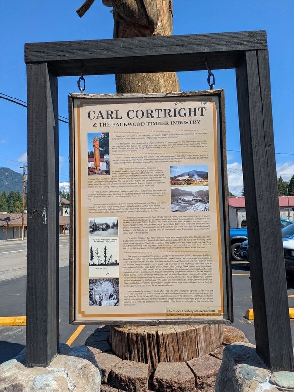
Photographed by Clayton Pickett, July 18, 2026
1. Carl Cortright Marker
It is fitting that I was carved with a chain saw from a 17' cedar log. The first marketable commodity produced in the Big Bottom was shingle bolts cut from cedar trees and floated down the Cowlitz River to Kelso. The river was the only transportation available at the end of the 19th century. Roads were wagon tracks. Markets were distant.
By 1911, twelve years after the first settlers came, there was enough population in this area to warrant a saw mill. It was located near Hager Creek where hydropower could be developed. A local building boom kept it busy cutting timbers and boards to erect the hotel and residences in the area.
In 1933 the Civilian Conservation Corp came to Packwood, working mostly in the National Forest building roads, campgrounds, lookouts and fighting fires. Two of the enrollees, Henry and Wesley Kerr, saw the timber potential of the area. They started the sawmill which became Packwood Lumber Company in 1945 and Pacific Lumber
this page online
In 1949, the Public Utility district finally ran electric lines to Packwood and solved that situation. Additional power also made it possible for both the mill and community to grow. By the time the mill closed in 1998, it was actually three mills in one: it could handle any log.
Timber on private lands along the river bottom was harvested first. There were some huge trees came out of this country. One Douglas fir felled about five miles west of Packwood potentially yielded enough plywood to cover 58 homes, inside and out. It was not too unusual to see a big load of logs pass through town, headed for the mill.
Packwood is surrounded on three sides by National Forest. After World War II, the Forest Service began offering timber for sale on a sustained yield basis. One of the larger logging companies in the Packwood area was Cotten Brothers; they were associated with Packwood Lumber Company. Smaller "gyppo" outfits

Photographed by Clayton Pickett, July 18, 2026
2. Carl Cortright Statue
On another occasion, Bud Panco and Bob Kehoe were logging in the Soda Springs area when Bud's father, John Panco of Panco & Matchett Logging, asked them to pull a half-mile long cable down to the beginning of Cortright creek road. They got to talking and forgot about that task. They drug that cable along State Highway 5 (now White Pass Highway) all the way to Packwood, around the Locust Café and along Combs Road to Bud's house. They certainly heard about that stunt.
The largest timber sale in this area was sold by the Forest Service in 1947. More than 80 Million Board Feet of timber was harvested in the Willame Creek drainage. Such a large sale was required in order to build the Skate Creek road from near Ashford, through the canyon and more than five miles up Willame Creek. Practically every Forest road and trail in the Packwood area was built in connection with timber sales: Butter Creek, Carlton Creek, Cortright Creek, Davis Creek, Hager Creek, Johnson Creek, Lava Creek, Smith Creek and many others. Recreation opportunities abounded with increased access to the mountains. Block or clear cutting, the preferred method of timber harvest in dense forests, created openings where deer and elk could flourish on new growth. Vistas were created where visitors could see the magnificent scenery. On the other hand, people flying over the area, or whisking along the highway in the valley saw the openings as a blight upon the landscape. They could not appreciate the advantages of timber harvest in the National Forest, such as the jobs, lumber, paper products, access for recreation and such.
And so it was, the prosperity ended after 1990 when the Endangered Species Act flew in on the wings of the spotted owl. Timber harvest in the National Forest virtually stopped, the mill closed and soon even the Forest Service left. It was a severe blow all over the northwest. Thankfully, the tourist industry, always bubbling under the bustle of the timber industry, continued to grow locally. It holds promise of a renewed prosperity for Packwood. The future is as bright as the vision of the community.
Erected by Dave Garoutte and the White Pass Country Historical Museum.
Topics. This historical marker is listed in these topic lists: Environment • Industry & Commerce • Settlements & Settlers. A significant historical year for this entry is 1911.
Location. 46° 36.523′ N, 121° 40.169′ W. Marker is in Packwood, Washington, in Lewis County. It is on U.S. 12 0.1 miles north of Willame Street, on the right when traveling north. Touch for map. Marker is at or near this postal address: 13040 US-12, Packwood WA 98361, United States of America. Touch for directions.

Regionally, this marker is in Southwest Washington State. It is also on the American Pacific Coast, in the Pacific Northwest, and in the Lewis & Clark Corridor. Globally, it is in North America, in the Cascade Range, on the Ring of Fire, on the Pacific Rim, in the Western Hemisphere, in the Western World, and in the Anglosphere.
Other nearby markers. At least 8 other markers are within 12 miles of this marker, measured as the crow flies: Packwood (approx. 0.2 miles away); The Palisades are Clues to the Past (approx. 7.7 miles away); Traveling Over the Cascades: Past and Present (approx. 7.7 miles away); A Forest Returns (approx. 10.9 miles away); Glacier Scars (approx. 10.9 miles away); River-Carved Canyon (approx. 10.9 miles away); Rescuing Reflection Lakes (approx. 11.4 miles away); Shadow of the Past (approx. 12 miles away). Touch for a list and map of all markers in Packwood.
Credits. This page was last revised on July 23, 2026. It was originally submitted on July 19, 2026, by Clayton Pickett of Richland, Washington. This page has been viewed 12 times since then. Photos: 1, 2. submitted on July 19, 2026, by Clayton Pickett of Richland, Washington. • James Hulse was the editor who published this page.
