
Great Shelford in Cambridgeshire, England, United Kingdom — Northwestern Europe (the British Isles)
Great Shelford
Photographed by Ray Gurganus, April 28, 2026
1. Great Shelford Marker
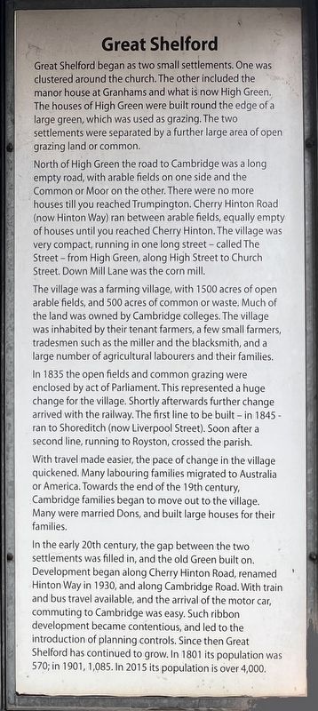
North of High Green the road to Cambridge was a long empty road, with arable fields on one side and the Common or Moor on the other. There were no more houses till you reached Trumpington. Cherry Hinton Road (now Hinton Way) ran between arable fields, equally empty of houses until you reached Cherry Hinton. The village was very compact, running in one long street - called The Street - from High Green, along High Street to Church Street. Down Mill Lane was the corn mill.
The village was a farming village, with 1500 acres of open arable fields, and 500 acres of common or waste. Much of the land was owned by Cambridge colleges. The village was inhabited by their tenant farmers, a few small farmers, tradesmen such as the miller and the blacksmith, and a large number of agricultural labourers and their families.
In 1835 the open fields and common grazing were enclosed by act of Parliament. This represented a huge change for the village. Shortly afterwards further change arrived with the railway. The first line to be built in 1845 ran to Shoreditch (now Liverpool Street). Soon after a second line, running to Royston, crossed the parish.
With travel made easier, the pace of change in the village quickened. Many labouring families migrated to Australia or America. Towards the end of the 19th century, Cambridge families began to move out to the village. Many were married Dons, and built large houses for their families.
In the early 20th century, the gap between
this page online
Topics. This historical marker is listed in these topic lists: Railroads & Streetcars • Roads & Vehicles • Settlements & Settlers.
Location. 52° 8.922′ N, 0° 8.392′ E. Marker is in Great Shelford, England, in Cambridgeshire. It is at the intersection of Station Road and Station Court, on the left when traveling north on Station Road. The marker is located across the tracks from the railway station. Touch for map. Marker is in this post office area: Great Shelford, England CB22 5LR, United Kingdom. Touch for directions.

Regionally, this marker is in England’s East Anglia. Globally,
Photographed by Ray Gurganus, April 28, 2026
2. Mural adjoining Great Shelford Marker
Other nearby markers. At least 6 other markers are within 6 kilometers of this marker, measured as the crow flies: Little Shelford Village Design Key (approx. 1.2 kilometers away); Rupert Brooke (approx. 4.4 kilometers away); Cambridge Station Turntable Pivot Cone (approx. 5.2 kilometers away); Mill Road Cemetery (approx. 6 kilometers away); Stephen Perse (approx. 6.2 kilometers away); Great St. Mary’s Datum (approx. 6.5 kilometers away).
Credits. This page was last revised on July 23, 2026. It was originally submitted on July 22, 2026, by Ray Gurganus of Washington, District of Columbia. This page has been viewed 8 times since then. Photos: 1, 2. submitted on July 22, 2026, by Ray Gurganus of Washington, District of Columbia. • Andrew Ruppenstein was the editor who published this page.
