Kelleys Island in Erie County, Ohio — The American Midwest (Great Lakes)
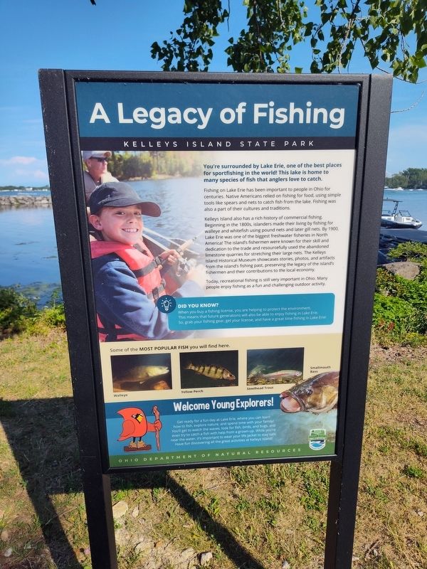
A Legacy of Fishing
Kelleys Island State Park
Photographed by Craig Doda, July 4, 2026
1. A Legacy of Fishing Marker
You're surrounded by Lake Erie, one of the best places for sportfishing in the world! This lake is home to many species of fish that anglers love to catch.
Fishing on Lake Erie has been important to people in Ohio for centuries. Native Americans relied on fishing for food, using simple tools like spears and nets to catch fish from the lake. Fishing was also a part of their cultures and traditions.
Kelleys Island also has a rich history of commercial fishing. Beginning in the 1800s, islanders made their living by fishing for walleye and whitefish using pound nets and later gill nets. By 1900, Lake Erie was one of the biggest freshwater fisheries in North America! The island's fishermen were known for their skill and dedication to the trade and resourcefully used the abandoned limestone quarries for stretching their large nets. The Kelleys Island Historical Museum showcases stories, photos, and artifacts from the island's fishing past, preserving the legacy of the island's fishermen and their contributions to the local economy.
Today, recreational fishing is still very important in Ohio. Many people enjoy fishing as
this page online
Did You Know?
When you buy a fishing license, you are helping to protect the environment. This means that future generations will also be able to enjoy fishing in Lake Erie. So, grab your fishing gear, get your license, and have a great time fishing in Lake Erie!
Welcome Young Explorers!
Get ready for a fun day at Lake Erie where you can learn how to fish, explore nature, and spend time with your family! You'll get to watch for fish, look for fish, birds, and bugs, and even try to catch a fish with help from a grown-up. While you're near the water, it's important to wear your life jacket to stay safe. Have fun discovering all the great activities at Kelleys Island!
Erected by Ohio Department Of Natural Resources, Ohio State Parks & Watercraft.
Topics. This historical marker is listed in these topic lists: Animals • Parks & Recreational Areas. A significant historical year for this entry is 1900.
Location. 41° 37.024′ N, 82° 42.24′ W. Marker is on Kelleys Island, Ohio, in Erie County. It is at the intersection of Division Street and Titus Road, on the right when traveling north on Division
Photographed by Craig Doda, July 4, 2026
2. A Legacy of Fishing Marker

Regionally, this marker is on the Lake Erie Shore and in the Western Reserve. It is also in the American Midwest and in the Corn Belt. Globally, it is in North America, on the Great Lakes, in the Western Hemisphere, in the Western World, and in the Anglosphere. Historically, it finds itself in what was once the Haudenosaunee (Iroquois) Confederacy, the territory of the Mississippian Culture, and the Northwest Territory.
Other nearby markers. At least 8 other markers are within walking distance of this marker: North Bay Quarry (a few steps from this marker); The Crusher Trail (about 700 feet away, measured in a direct line); The Crusher Process (about 700 feet away); a different marker also named The Crusher Trail (about 700 feet away); Island History (about 700 feet away); Columbus Limestone / Kelleys Island Lime & Transport Co. (about 700 feet away); Welcome to Glacial Grooves Geological Preserve (about 800 feet away); The Small, but Mighty (approx. 0.2 miles away). Touch for a list and map of all markers in Kelleys Island.
Another marker is no longer nearby. Glacial Grooves State Memorial (was about 700 feet away but has been permanently removed).
Credits. This page was last revised on August 5, 2026. It was originally submitted on July 27, 2026, by Craig Doda of Napoleon, Ohio. This page has been viewed 13 times since then. Photos: 1, 2. submitted on July 27, 2026, by Craig Doda of Napoleon, Ohio. • Devry Becker Jones was the editor who published this page.
