Monroe Township near West Liberty in Logan County, Ohio — The American Midwest (Great Lakes)
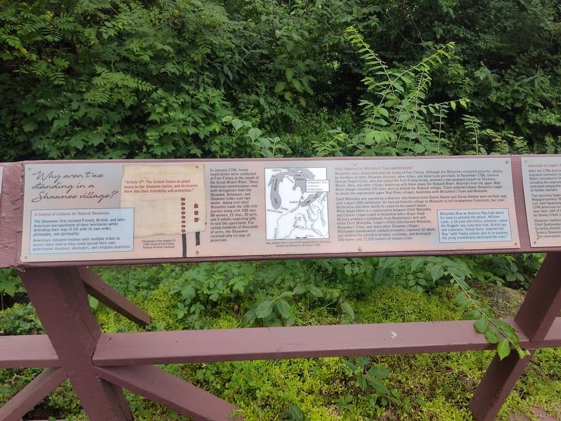
Why aren't we standing in a Shawnee village?
Photographed by Craig Doda, July 11, 2026
1. Why aren't we standing in a Shawnee village? Marker
A Contest of Cultures for Natural Resources
The Shawnees first resisted French, British, and later American encroachment of their territories while defending their way of life with its own order, philosophy, and spirituality.
Americans initiated treaties with multiple tribes to secure more land so they could spread their own government structure, ideologies, and religious practices.
"Article Vth. The United States do grant peace to the Shawnee nation, and do receive them into their friendship and protection."
In January 1786, treaty negotiations were conducted at Fort Finney at the mouth of the Great Miami River. Three American commissioners met with delegations from the Wyandot, Delaware, and Shawnee tribes over two weeks. Aging civil chief Moluntha made the 100-mile journey along with 108 men, 88 women, 21 boys, 30 girls, and 5 infants expecting gifts to seal the agreement. For ceding hundreds of thousands of acres, the Shawnees received only six days of provisions.
What happened to Moluntha's Town and Mekoche?
All parties were dissatisfied with the treaty of Fort Finney. Although the Mekoches remained peaceful,
this page online
Chief Moluntha was warned by a deserter that frontiersmen Daniel Boone and Simon Kenton were on their way with Logan's 800 militiamen. He hurried from his village to Mekoche to tell headwoman Coitcheleh, her sister Nonhelema and other family to return to his council house. What began there as a conversation between Chief Moluntha and Colonel Logan ended in bloodshed when Major Hugh McGary grabbed a tomahawk from Nonhelema's belt and killed Chief Moluntha. Logan's militia then burned Mekoche, Moluntha's Town, and seven other Shawnee villages. Militiamen tomahawked subdued prisoners, captured 32 adults and children for potential

Photographed by Craig Doda, July 11, 2026
2. Why aren't we standing in a Shawnee village? Marker
Moluntha flew an America flag high above his town to prevent the attack. William Lytle, a 16-year-old militia volunteer, noted the flagpole was sixty feet high. British spy and translator, Simon Girty, reported the flag "with Yanky colours was to no purpose, the army immediately destroyed the town."
Erected by Piatt Castle Mac-A-Cheek; The Mac-A-Cheek Foundation for the Humanities; America 250: Ohio Commission.
Topics and series. This historical marker is listed in these topic lists: Indigenous Peoples and Communities • Military. In addition, it is included in the America 250: Ohio Commission series list. A significant historical month for this entry is January 1786.
Location. 40° 15.062′ N, 83° 43.623′ W. Marker is near West Liberty, Ohio, in Logan County. It is in Monroe Township. It is at the intersection of Local Road 47 and State Route 245, on the right when traveling north on Local Road 47. Touch for map. Marker is at or near this postal address: 10051 Township Rd 47, West Liberty OH 43357, United States of America. Touch for directions.

Regionally,
Photographed by Craig Doda, July 11, 2026
3. Why aren't we standing in a Shawnee village? Marker
Other nearby markers. At least 8 other markers are within walking distance of this marker: How the Mekoche Were Remembered (here, next to this marker); A History of Historic Markers (here, next to this marker); Great Council State Park (here, next to this marker); Hopewell Ceremonial Earthworks (here, next to this marker); Finding the Balance Between History & Legacy (here, next to this marker); Aftermath of Logan’s Raid (here, next to this marker); Industry on the Macacheek (here, next to this marker); Past Shawnee Villages (here, next to this marker). Touch for a list and map of all markers in West Liberty.
Credits. This page was last revised on August 7, 2026. It was originally submitted on July 30, 2026, by Craig Doda of Napoleon, Ohio. This page has been viewed 13 times since then. Photos: 1, 2, 3. submitted on July 30, 2026, by Craig Doda of Napoleon, Ohio. • Devry Becker Jones was the editor who published this page.
