Mount Pleasant in Charleston County, South Carolina — The American South (South Atlantic)
Snee Farm
Charles Pinckney National Historic Site
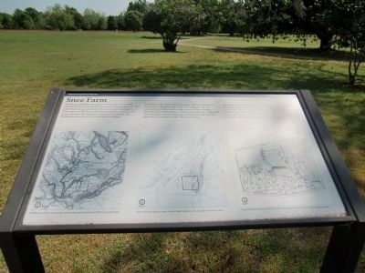
The Pinckney family owned Snee Farm from 1754 to 1817. Charles Pinckney inherited the property from his father in 1782. Snee Farm was one of Charles Pinckney’s seven plantations. At 715 acres it was Pinckney’s smallest plantation, and a favorite retreat from his Meeting Street house in Charleston. The Pinckneys came here to relax and spend holidays.
Throughout this early period, enslaved Africans and African Americans cultivated staple crops. The high ground was planted in provision crops, indigo, corn and later cotton; lowlands were planted in rice, and woodlands were suitable for cattle grazing and game hunting and provided pines for the extraction of turpentine and other naval stores.
Snee Farm represents over 200 years of agricultural use before the farming era ended with the sale and development of 687 acres in the 1960s. The sold property became residential subdivisions, a country club, and a golf course. The house and remaining acres was a family residence until 1990. This remnant is now preserved as Charles Pinckney National Historic Site.
[Map illustration captions:]
A 1780 map of the Lowcountry clearly shows the location of Pinckney’s Snee Farm.
This 1818 plat depicts some of Snee Farm’s features on year after Pinckney sold it.
Charles Pinckney National Historic Site encompasses the core area of historic Snee Farm.
Following is text from another marker, off the pathway east of the farmhouse:]
Archeology
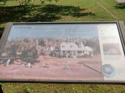
Archeology has played an important role in our understanding of Snee Farm and Charles Pinckney. Very few of Pinckney’s personal papers exist today, as the bulk of them were destroyed by the 1861 Charleston fire.
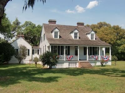
Through archeology, we have learned that the Pinckney era structures (1754-1817) that once stood in this part of Snee Farm were razed sometime in the early 19th century. The current theory is that one or more hurricanes may have damaged the farmhouse, kitchen, and other outbuildings. It is believed that when William Matthews purchased Snee Farm in 1828, he tore down the damaged buildings and built the present hous, which stands on the same site as Pinckney’s. The wings of the house were added in the 1930s by the Ewing-Stone family.
Today modern bricks are used to outline the Pinckney kitchen and farmhouse dependencies.
[Illustration captions:]
Excavations in the core area of Snee Farm revealed the location of the Pinckney farmhouse, well, kitchen, and other outbuildings.
Construction material and an 1826 penny found in the Pinckney well suggest that the well was filled when the
Pinckney structures were razed in the 1820s.
Different pieces of this platter were found in three of the excavated sites.
Erected by National Park Service, U.S. Deptartment of the Interior, Charles Pinckney National Historic Site.
Topics. This historical marker is listed in these topic lists: African Americans • Agriculture. A significant historical year for this entry is 1754.
Location. 32° 50.751′ N, 79° 49.48′ W. Marker is in Mount Pleasant, South Carolina, in Charleston County. Marker can be reached from Long Point Road, 0.6 miles west of U.S. 17 when traveling south. Markers are west of the parking area on the Charles Pinckney National Historic Site, south of Long Point Road. Touch for map. Marker is at or near this postal address: 1254 Long Point Road, Mount Pleasant SC 29464, United States of America. Touch for directions.
Other nearby markers. At least 8 other markers are within walking distance of this marker. Charles Pinckney - Statesman (within shouting distance of this marker); Archeology (within shouting distance of this marker); Indigo and Its Beginnings in South Carolina (within shouting distance of this marker); Snee Farm Historic Structures (about 300 feet away, measured in a direct line); Charles Pinckney (about 300 feet away); a different marker also named Charles Pinckney (about 300 feet
away); Rice Trunk (about 400 feet away); Slave Community (about 500 feet away). Touch for a list and map of all markers in Mount Pleasant.
Additional keywords. Slavery
Credits. This page was last revised on June 16, 2016. It was originally submitted on May 17, 2010, by Richard E. Miller of Oxon Hill, Maryland. This page has been viewed 1,011 times since then and 19 times this year. Photos: 1. submitted on May 9, 2010, by Richard E. Miller of Oxon Hill, Maryland. 2. submitted on May 10, 2010, by Richard E. Miller of Oxon Hill, Maryland. 3. submitted on May 9, 2010, by Richard E. Miller of Oxon Hill, Maryland. • Kevin W. was the editor who published this page.


