Riverwalk District in Reno in Washoe County, Nevada — The American Mountains (Southwest)
The Coming of the Iron Horse
Photographed by Douglass Halvorsen, August 7, 2026
1. The Coming of the Iron Horse Marker
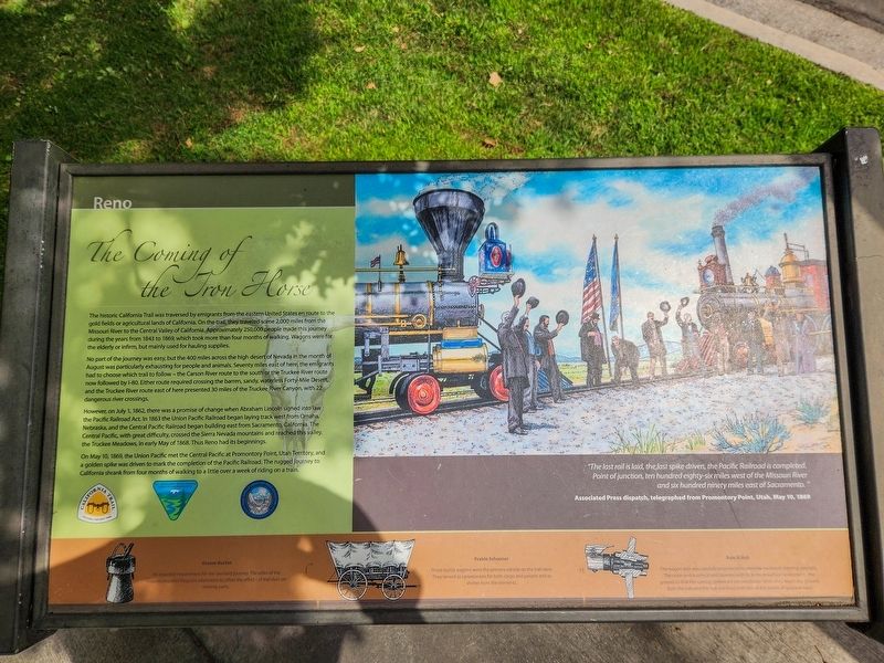
No part of the journey was easy, but the 400 miles across the high desert of Nevada in the month of August was particularly exhausting for people and animals. Seventy miles east of here, the emigrants had to choose which trail to follow – the Carson River route to the south or the Truckee River route now followed by I-80. Either route required crossing the barren, sandy, waterless Forty-Mile Desert, and the Truckee River route east of here presented 30 miles of the Truck River Canyon, with 22 dangerous river crossings.
However, on July 1, 1862, there was a promise of change when Abraham Lincoln signed into law the Pacific Railroad Act. In 1863 the Union Pacific
this page online
On May 10, 1869, the Union Pacific met the Central Pacific at Promontory Point, Utah Territory, and a golden spike was driven to mark the completion of the Pacific Railroad. The rugged journey to California shrank from four months of walking to a little over a week of riding on a train.
“The last rail is laid, the last spike driven, the Pacific Railroad is completed. Point of Junction, ten hundred eighty-six miles west of the Missouri River and six hundred ninety miles east of Sacramento.”
Associated Press dispatch, telegraphed from Promontory Point, Utah, May 10, 1869
Grease Bucket
An essential requirement for the overland journey. The axles of the wagons required frequent lubrication to offset the effects of trail dust on moving parts.
Prairie Schooner
These sturdy wagons were the primary vehicle on the trail
Photographed by Douglass Halvorsen, August 7, 2026
2. The Coming of the Iron Horse Marker
Axle & Hub
The wagon axle was carefully engineered to provide maximum-bearing strength. The outer end is conical and tapered with its bottom surface horizontal to the ground so that the turning spokes are perpendicular when they touch the ground. Both the axle and the hub are lines with iron at the points of greatest wear.
Topics and series. This historical marker is listed in these topic lists: Railroads & Streetcars • Roads & Vehicles. In addition, it is included in the California Trail, and the First Transcontinental Railroad series lists. A significant historical year for this entry is 1843.
Location. 39° 31.345′ N, 119° 49.279′ W. Marker is in Reno, Nevada, in Washoe County. It is in the Riverwalk District. It is on Riverside Drive, on the right when traveling west. Touch for map. Marker is at or near this postal address: 727 Riverside Drive, Reno NV 89503, United States of America. Touch for directions.

Regionally, this marker is in the Sierra Nevada and in the Lake Tahoe Basin. It is also in the American Mountain West. Globally, it is in North America, the Western Hemisphere, the Western World, and the Anglosphere. Historically, it finds itself in what was once New Spain and also Mexico’s Alta California.
Other nearby markers. At least 8 other markers are within walking distance of this marker: About Your Journey... (here, next to this marker); Powning’s Addition Conservation District (a few steps from this marker); Fish of the Truckee River (a few steps from this marker); First Church of Christ, Scientist, Reno (about 700 feet away, measured in a direct line); Culture and History (about 700 feet away); McKinley Park School (approx. 0.2 miles away); The Humboldt Trail (approx. 0.2 miles away); Wingfield Park (approx. ¼ mile away). Touch for a list and map of all markers in Reno.
Related markers. Click here for a list of markers that are related to this marker.
Credits. This page was last revised on August 13, 2026. It was originally submitted on August 13, 2026, by Douglass Halvorsen of Klamath Falls, Oregon. This page has been viewed 19 times since then. Photos: 1, 2. submitted on August 13, 2026, by Douglass Halvorsen of Klamath Falls, Oregon. • Andrew Ruppenstein was the editor who published this page.
