Calhoun Isles in Minneapolis in Hennepin County, Minnesota — The American Midwest (Upper Plains)
Ȟeyáta Othúŋwe
Cloud Man Village at Bde Maka Ska 1829-1839
Photographed by McGhiever, May 24, 2026
1. Ȟeyáta Othúŋwe Marker
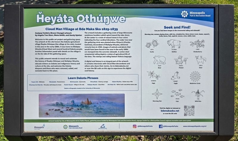
Zaníyaŋ Yutókča (Brave Change) artwork by Angela Two Stars, Mona Smith, and Sandy Spieler
Welcome to this public art project and gathering space. The artwork at this site honors the Dakota agricultural village Ȟeyáta Othúŋwe (the village at the side), located in this area in the early 1800s. It was home to Maḣpiya Wic̣aṡta (Cloud Man) and several hundred Dakota people. Another information panel with details on the village is on the far side of this gathering space.
This public artwork intends to reveal and celebrate the history of Ȟeyáta Othúŋwe and Maḣpiya Wic̣aṡta, educate visitors on Dakota and Indigenous history and culture at the site, and welcome the Dakota diaspora and those who were removed, exiled, and excluded back to this place.
The artwork includes a gathering circle of large Minnesota sandstone boulders which spiral toward the lake shore. At the center is a circle of natural stone in four colors indicating the four cardinal directions. The cedar tree near the gathering circle was planted when Ohiyes'a (Charles Eastman), descendant of
this page online
A digital oral history is an integral part of the artwork. It contains interviews with Cloud Man descendants and others who share their stories. Go to bdemakaska.net or scan the QR code on this sign to experience the digital oral history.
Learn Dakota Phrases
Taŋyaŋ Yahi - Welcome
Wac̣iŋṭaŋka - Perseverance
Wóoḣaŋwaṡte - Generosity
Wówaditake - Bravery, courage
Daḳota Wic̣oḣaŋ - Dakota way of life
Ohiŋniyaŋ Ded Waṭi Kte - This place will always be home
Ȟeyáta Othúŋwe - Village to the side
Maḣpiya Wic̣aṡta - Cloud Man
Bde Maḳa Ska - White Earth Lake/White Banks Lake
Dakota orthography created at the University of Minnesota
Sioux Village, Lake Calhoun, near Fort Snelling, painting by George Catlin, 1835-1836, collection of Smithsonian American Art Museum
Can

Photographed by McGhiever, May 24, 2026
2. Ȟeyáta Othúŋwe Marker and part of Zaníyaŋ Yutókča (Brave Change) on the Grand Ro
Morning star, woman playing drum, wild rice, strawberries, three sisters (corn, beans, squash), turtle, heron, fish, squirrel, racoon, crow, rabbit, bees
Ḳéya (Turtle)
Ṭaṭáŋka (Buffalo)
C̣aŋp̣á (Chokecherry)
Maṭó (Bear)
Waḣcá (Flower)
Ṭáḣca (Deer)
P̣eżíḣota (Sage)
Waŋbdí (Eagle)
Medicine Circle
Morning Star
Hoġaŋ (Fish)
Psíŋ (Wild Rice)
Artwork funded by City of Minneapolis Art in Public Places, gathering space funded by Minneapolis Park and Recreation Board, signage funded by a Metropolitan Council regional recreation open space grant
Erected by the Minneapolis Park & Recreation Board.
Topics. This historical marker is listed in this topic list: Indigenous Peoples and Communities. A significant historical year for this entry is 1829.
Location. 44° 56.131′ N, 93° 18.387′ W. Marker is in Minneapolis, Minnesota, in Hennepin County. It is in Calhoun Isles. It is on Richfield Road south of W. 36th Street, on the right when traveling south. The marker is between the paved Grand Rounds trails on the southeast shore of Bde Maka Ska. There is a pay parking lot just to the north. Touch for map. Marker is in this post office area: Minneapolis MN 55419, United States of America. Touch for directions.

Regionally, this marker is in the Twin Cities Metropolitan Area. It is also in the American Midwest, in the Corn Belt, and in the Great River Road Region. Globally, it is in North America, the Western Hemisphere, the Western World, and the Anglosphere. Historically, it finds itself in what was once Rupert’s Land, the territory of the Mississippian Culture, and the Louisiana Purchase.
Other nearby markers. At least 8 other markers are within walking distance of this marker: A different marker also named Ȟeyáta Othúŋwe (about 400 feet away, measured in a direct line); First Dwelling in Minneapolis (approx. 0.3 miles away); Harriet Bandshells / Our Park Legacy (approx. half a mile away); First School House (approx. half a mile away); Geology of Minnesota (approx. 0.6 miles away); Como–Harriet Streetcar Line (approx. 0.6 miles away); You Are Here… Lake Calhoun (approx. 0.9 miles away); In Memory of the Boys of Our Navy (approx. 0.9 miles away). Touch for a list and map of all markers in Minneapolis.
Credits. This page was last revised on August 14, 2026. It was originally submitted on August 14, 2026, by McGhiever of Minneapolis, Minnesota. This page has been viewed 13 times since then. Photos: 1, 2. submitted on August 14, 2026, by McGhiever of Minneapolis, Minnesota.
