Trevilians in Louisa in Louisa County, Virginia — The American South (Mid-Atlantic)
The Netherland's Tavern

Photographed by Evan Dwyer, June 11, 2026
1. The Netherland's Tavern Marker
This tavern was used as a hospital for the wounded.
The original tavern was built in the 1700's era
Erected 1999 by Russell B. Anderson (The Netherland's Tavern and Civil War Museum).
Topics. This historical marker is listed in this topic list: War, US Civil. A significant historical date for this entry is June 10, 1864.
Location. 38° 3.028′ N, 78° 3.601′ W. Marker is in Louisa, Virginia, in Louisa County. It is in Trevilians. It is on Oakland Road (County Route 613) 0.3 miles east of Louisa Road (U.S. 33), on the right when traveling north. Marker is at the southern end of the driveway for the replica Netherland Tavern. Touch for map. Marker is in this post office area: Louisa VA 23093, United States of America. Touch for directions.

Regionally, this marker is in the Piedmont and in Central Virginia. It is also in the American South and specifically in the Upper South. Globally, it is in North America, the Western Hemisphere, the Western World, and the Anglosphere. Historically, it finds
this page online
Other nearby markers. At least 8 other markers are within 3 miles of this marker, measured as the crow flies: Netherland Tavern (about 600 feet away, measured in a direct line); Railroad Rails (approx. ¾ mile away); Custer Rescued (approx. ¾ mile away); Custer's First Last Stand (approx. ¾ mile away); Battle of Trevillians (approx. 0.9 miles away); Battle of Trevilian Station (approx. 0.9 miles away); Ogg Farm (approx. 2.2 miles away); Bibb's Crossroads (approx. 2.6 miles away). Touch for a list and map of all markers in Louisa.
Other markers no longer nearby. Trevilian Station Battle (was approx. 0.8 miles away but has been confirmed missing); Battle of Trevilians (was approx. 0.9 miles away but has been replaced with another marker now near it).
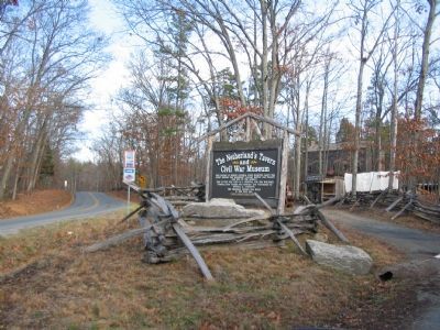
More about this marker. The marker originally served as a road sign marking the entrance to the tavern during its era of use as a privately-run museum in the early 2000s. The "museum" component of the

Photographed by Evan Dwyer, June 11, 2026
2. The Netherland's Tavern Marker
Context view. The replicated tavern is in the background at right.
Regarding The Netherland's Tavern. The tavern standing behind the marker is a replica built in 1999 by Russell B. Anderson. It sits next to the footprint of the original building, which was oriented to face the Gordonsville Road (Rt. 33/Louisa Road) and later the railroad. The replica was built facing west instead of south. The original foundation is still visible in the yard.
The tavern's name comes from William A. Netherland, an operator who rented the building from owner Richard F. Omohundro prior to the Civil War. William Netherland purchased it outright in 1862. The tavern was referred to by its proprietor's surname in the years prior - e.g., Neff's Tavern, and Sanner's Tavern before that, possibly with other names sprinkled in between. Both "The Netherland Tavern" and "Netherland's Tavern" are appropriate titles.

Photographed by Evan Dwyer, June 11, 2026
3. Netherland Tavern Replica
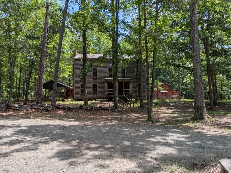
The tavern replica, constructed in 1999 by Russell B. Anderson, is no longer used as a museum - but it is not abandoned. The Trevilian Station Battlefield Foundation hosts an annual dinner here as a fundraiser. Also of note, the tavern when replicated was not built on the original footprint - the original site is marked in the yard - nor does the replica retain the original orientation. The original tavern was oriented 90 degrees to the right of the frame here, and faced towards the railroad. The late historian Eric J. Wittenberg also asserted that Trevilian Station itself was in this vicinity, rather than a mile away like the current station.
The date of construction for the original building is either the late 1790s, when William Hughes subdivided his property to his offspring, or in the early 1820s when John Wood, Jr., bought the property. Wood either renovated an existing building or built the tavern himself. It's location put it astride two important routes through central Virginia, the Fredericksburg Plank Road (now Oakland Road) and the Gordonsville Road. Historic traces of the former still exist at either end of the driveway.
Also see . . .
1. American Battlefield Trust - Trevilian Station. An authoritative source for information on the battle and battlefield preservation. (Submitted on August 15, 2026, by Evan Dwyer of Richmond, Virginia.)
2. Trevilian Station Battlefield Foundation. The TSBF has worked to preserve core areas of the Trevilian Station Battlefield, including the C.G. Trevilian House, which is open for tours seasonally, as well as hosting the Netherland Tavern annual dinner. The website includes information about the battle, their efforts, and the Trevilian Station Driving Tour, as well as how to
Photographed by Evan Dwyer, June 11, 2026
4. The Netherland Tavern Complex
Full view of the replicated tavern complex, including a roadside store, a barn, and ancillary farm structures.
3. Archived Netherlands Tavern & Civil War Museum Website. The pages of the website about the tavern when it was a museum have been saved to the Internet Archive. They contain substantial information about the tavern's history, the builder of the replica, and the previous museum's displays and attractions. (Submitted on August 15, 2026, by Evan Dwyer of Richmond, Virginia.)
4. Battle of Trevilian Station Virtual Tour by Markers. A set of markers that document the Battle of Trevilian Station, June 11-12, 1864. The order of appearance is generally aligned to the Trevilian Station Battlefield Foundation driving tour, with accommodations made for convenience both in the town of Louisa at the beginning of the tour, and on the eastbound side of Route 33 headed back towards the cemetery. Because the C.G. Trevilian House at the 'modern' station does not have its own marker, reviewing this database for accompanying information when reading about the railroad tracks there is

Photographed by Evan Dwyer, June 11, 2026
5. Fredericksburg Plank Road Trace
Note the driveway used to access the marker is actually the Civil War-era roadbed of the Fredericksburg Plank Road, prior to modern re-routing.

Photographed by Evan Dwyer, June 11, 2026
6. Fredericksburg Plank Road Trace
The trace of the old road continues past the parking area and is evident heading towards the railroad, as seen here.
Photographed by Craig Swain, January 12, 2008
7. The Netherland's Tavern Marker (Original Configuration)
As originally painted and erected during the replica tavern's period as a museum.
Credits. This page was last revised on August 15, 2026. It was originally submitted on August 15, 2026, by Evan Dwyer of Richmond, Virginia. This page has been viewed 27 times since then. Photos: 1, 2. submitted on August 15, 2026, by Evan Dwyer of Richmond, Virginia. 3. submitted on August 14, 2026, by Evan Dwyer of Richmond, Virginia. 4. submitted on August 15, 2026, by Evan Dwyer of Richmond, Virginia. 5, 6. submitted on August 14, 2026, by Evan Dwyer of Richmond, Virginia. 7. submitted on January 20, 2008, by Craig Swain of Leesburg, Virginia.
