Chance in Essex County, Virginia — The American South (Mid-Atlantic)
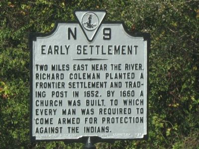
Early Settlement
Erected 1929 by Conservation & Development Commission. (Marker Number N-9.)
Topics and series. This historical marker is listed in these topic lists: Churches & Religion • Colonial Era • Native Americans • Settlements & Settlers. In addition, it is included in the Virginia Department of Historic Resources (DHR) series list. A significant historical year for this entry is 1652.
Location. 38° 4.019′ N, 77° 0.589′ W. Marker is in Chance, Virginia, in Essex County. Marker is on Tidewater Trail (U.S. 17) north of Laytons Landing Road, on the right when traveling north. Touch for map. Marker is in this post office area: Champlain VA 22438, United States of America. Touch for directions.
Other nearby markers. At least 8 other markers are within 7 miles of this marker, measured as the crow flies. Layton’s Landing Wharf and Ferry (a few steps from this marker); Saunders’s Wharf (approx. 1.7 miles away); Pissaseck Indians (approx. 3.1 miles away); Leedstown (approx. 3.1 miles away); John Pratt Hungerford (approx. 3.1 miles away); Vauter's Church (approx. 3˝ miles away); Portobacco Indians (approx. 4˝ miles away); Essex County / Caroline County (approx. 6.9 miles away).
Also see . . . On the Road in Essex County - N-9 Early Settlement. 2020 article by Zorine Shirley in the River Country News. Excerpt:
Richard Coleman, a planter in Colonial America, was able to acquire large land grants on both sides of the Rappahannock River around Warsaw and Tappahannock and later, north of Occupacia Creek, in the early 1650’s. He obtained the land, in accordance with the Charter established by King James I, by paying the passage of British colonists who could come to the new world, establish a residence, and work on the labor-intensive tobacco farms.(Submitted on September 17, 2020.)
Credits. This page was last revised on September 17, 2020. It was originally submitted on October 21, 2007, by Laura Troy of Burke, Virginia. This page has been viewed 2,043 times since then and 52 times this year. Photo 1. submitted on October 21, 2007, by Laura Troy of Burke, Virginia. • J. J. Prats was the editor who published this page.
Editor’s want-list for this marker. Wide shot of marker and its surroundings. • Can you help?
