Near South Side in Chicago in Cook County, Illinois — The American Midwest (Great Lakes)
Decline 1905-1965

Photographed by Sean P. Flynn, August 14, 2026
1. Decline 1905-1965 Marker
1905 Construction of major commercial buildings in the area for Ford, Eastman Kodak and Western Bank Note companies
1909 Marshall Field Jr. house at 1919 Prairie is sold to the Gatlin Institute, a hospital which treats drug and alcohol addiction
1912 First section of R. R. Donnelley & Sons printing plant built at Calumet and 21st
1915 Allerton house at 1936 Prairie demolished and replaced by Hump Hairpin Mfg. Co. factory, the first large commercial building on Prairie
1920 Census shows 26 residences still occupied by original families and an equal number converted to rooming houses with up to 45 persons each
1922 Newspaper article estimates investment in the area by the automobile industry at $100 million and by the publishing industry at $20 million
1923 First Chicago zoning ordinance designates entire area for commercial purposes
1933 Multiple concession stands and parking lots built along Prairie for Chicago World's Fair
1944 Addie Hibbard Gregory, the last original resident on Prairie Avenue, moves from the street after 77 years and her home at 1638 Prairie is razed
1949 Former resident Arthur Meeker publishes a fictional account of life on the street in the late 1800s entitled Prairie Avenue
Topics. This historical marker is listed in these topic lists: Architecture • Industry & Commerce • Roads & Vehicles. A significant historical year for this entry is 1905.
Location. 41° 51.429′ N, 87° 37.253′ W. Marker
this page online

Regionally, this marker is on Chicago’s South Side. It is also in the American Midwest. Globally, it is in North America, on the Great Lakes, in the Western Hemisphere, in the Western World, and in the Anglosphere. Historically, it finds itself in what was once the Viceroyalty of New France, the territory of the Mississippian Culture, and the Northwest Territory.
Other nearby markers. At least 8 other markers are within walking distance of this marker: Lost Houses of Prairie Avenue: 1800-1900 Blocks (West Side) (here, next to this marker); Lost Houses of Prairie Avenue: 2000-2100 Blocks (a few steps from this marker); Rebirth 1966-2004 (a few steps from this marker); Glory Days 1872-1904 (a few steps from this marker);

Photographed by Sean P. Flynn, August 14, 2026
2. Decline 1905-1965 Marker near the front entrance to the Chicago Women's Park and Gardens
Also see . . . Addie Hibbard Gregory on Find a Grave. (Submitted on August 19, 2026, by Sean P. Flynn of Oak Park, Illinois.)

Photographed by Sean P. Flynn, August 14, 2026
3. Prairie Avenue Historic District
Chicago Women's Park and Gardens is in the distance, with several markers affixed to its Prairie Avenue fence.

Photographed by Alma B. Robert, Camera Club; courtesy of Chicago History Museum (ICHi-038210), circa 1950
4. The Marshall Field Jr. residence at 1919 S. Prairie
The home still stands today, and was converted into luxury condominiums in 2006.

Photographed by Charles R. Clark; courtesy of Chicago History Museum (ICHi-071926), circa 1914
5. Allerton Residence at 1936 S. Prairie
Samuel Allerton, a meatpacking leader, took ownership of the home after he married the daughter of the original owner, Daniel Thompson. The home was torn down about a year after this photo was taken and replaced by a manufacturing plant, which has also since been demolished. A modern condo complex stands at the location today.
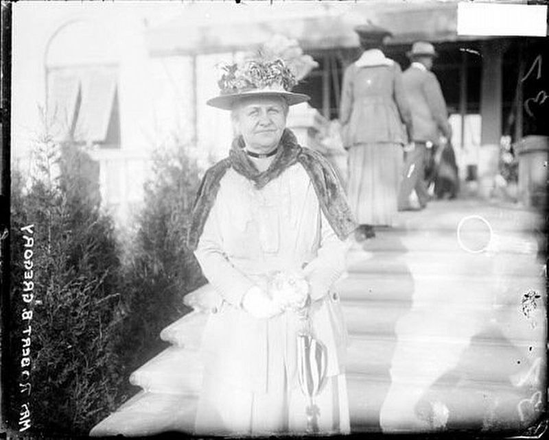
Chicago Daily News Collection, Chicago History Museum (DN-0068911), circa 1917
6. Addie Hibbard Gregory (1859-1947)
Addie's father, William Hibbard, came to Chicago from Dryden, N.Y., in 1840, and became leader of a hardware wholesaler. His home at 1701 S. Prairie was built in 1869 and designed by William Le Baron Jenney, who is credited with later designing the world's first skyscraper. It was torn down in 1932. Addie was Hibbard's oldest child, and in 1880 she married Robert Gregory, who for many years was the leader of Lyon & Healy, a Chicago-based manufacturer of musical instruments. The Gregorys remained in the Prairie Avenue District, and Addie stayed here for almost 30 years after her husband's death. Addie died in 1947 and is buried in Graceland Cemetery on Chicago's north side.
Credits. This page was last revised on August 25, 2026. It was originally submitted on August 19, 2026, by Sean P. Flynn of Oak Park, Illinois. This page has been viewed 18 times since then. Photos: 1, 2, 3, 4, 5. submitted on August 19, 2026, by Sean P. Flynn of Oak Park, Illinois. 6. submitted on August 25, 2026, by Sean P. Flynn of Oak Park, Illinois.
