Near Megler in Pacific County, Washington — The American West (Northwest)
Dangerous Days in "Dismal Nitch"
Photographed by Barry Swackhamer, June 10, 2026
1. Dangerous Days in "Dismal Nitch" Marker
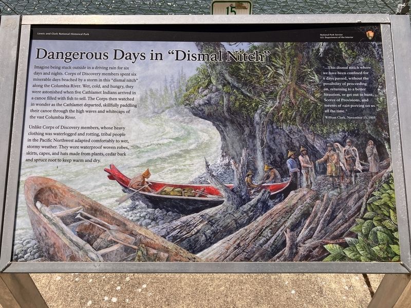
Unlike Corps of Discovery members, whose heavy clothing was waterlogged and rotting, tribal people in the Pacific Northwest adapted comfortably to wet, stormy weather. They wore waterproof woven robes, skirts, capes, and hats from plants, cedar bark and spruce root to keep warm and dry.
"...This dismal nitch where we have been confined for 6 days passed, without the possibility of proceeding on, returning to a better Situation, or get out to hunt, Scarce of Provisions, and torrents of rain poreing on us all the time." William Clark, November 15, 1805
Erected by National Park Service.
Topics and series. This historical marker is listed in these
this page online
Location. 46° 14.953′ N, 123° 51.613′ W. Marker is near Megler, Washington, in Pacific County. It is on Lewis and Clark Trail Highway (Washington Route 401) near Hungry Harbor Lane, on the right when traveling east. Touch for map. Marker is in this post office area: Naselle WA 98638, United States of America. Touch for directions.

Regionally, this marker is in Southwest Washington State. It is also on the American Pacific Coast, in the Pacific Northwest, and in the Lewis & Clark Corridor. Globally, it is in North America, on the Ring of Fire, on the Pacific Rim, in the Western Hemisphere, in the Western World, and in the Anglosphere.
Other nearby markers. At least 8 other markers are within 3 miles of this marker, measured as the crow flies: Crossing the River (within shouting distance of this marker); Salmon Fortunes (within shouting distance of this marker); Lewis & Clark at Dismal Nitch (approx. 0.2 miles away); Chief Skamokawa/"Great joy in camp" (approx.
Photographed by Barry Swackhamer, June 10, 2026
2. Dangerous Days in "Dismal Nitch" Marker
Another marker is no longer nearby. Columbia River Explorers (was approx. 1.3 miles away but has been confirmed missing).
Credits. This page was last revised on August 21, 2026. It was originally submitted on August 21, 2026, by Barry Swackhamer of Brentwood, California. This page has been viewed 14 times since then. Photos: 1, 2. submitted on August 21, 2026, by Barry Swackhamer of Brentwood, California.
