
Bulltown in Braxton County, West Virginia — The American South (Appalachia)
Confederate Overlook
Photographed by Craig Doda, August 2, 2026
1. Confederate Overlook Marker
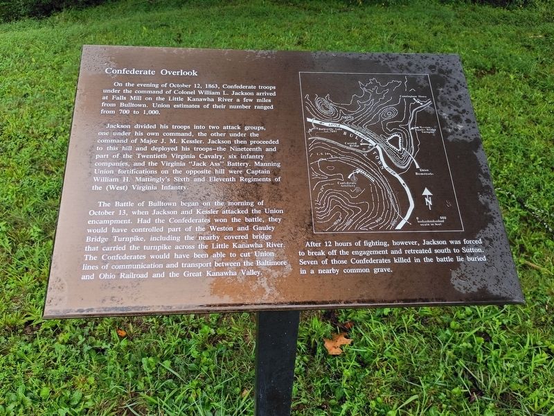
On the evening of October 12, 1863, Confederate troops under the command of Colonel William L. Jackson arrived at Falls Mill on the Little Kanawha River a few miles from Bulltown. Union estimates of their number ranged from 700 to 1,000.
Jackson divided his troops into two attack groups, one under his own command, the other under the command of Major J. M. Kessler. Jackson then proceeded to this hill and deployed his troops—the Nineteenth and part of the Twentieth Virginia Cavalry, six infantry companies, and the Virginia "Jack Ass" Battery. Manning Union fortifications on the opposite hill were Captain William H. Mattingly's Sixth and Eleventh Regiments of the (West) Virginia Infantry.
The Battle of Bulltown began on the morning of October 13, when Jackson and Kessler attacked the Union encampment. Had the Confederates won the battle, they would have controlled part of the Weston and Gauley Bridge Turnpike, including the nearby covered bridge that carried the turnpike across the Little Kanawha River. The Confederates would have been able to cut Union lines of communication and transport between the Baltimore and
this page online
After 12 hours of fighting, however, Jackson was forced to break off the engagement and retreated south to Sutton. Seven of those Confederates killed in the battle lie buried in a nearby common grave.
Topics. This historical marker is listed in this topic list: War, US Civil. A significant historical date for this entry is October 12, 1863.
Location. 38° 47.211′ N, 80° 34.02′ W. Marker is in Bulltown, West Virginia, in Braxton County. It is at the intersection of Gauley Turnpike and Millstone Run Road, on the right when traveling east on Gauley Turnpike. Touch for map. Marker is at or near this postal address: 1411 Bulltown Campground Rd, Napier WV 26631, United States of America. Touch for directions.

Regionally, this marker is in North Central West Virginia. It is also in the American South, specifically in the Upper South, in Appalachia, and specifically in Southern Appalachia. Globally, it is in North America, the Western Hemisphere, the Western World, and the Anglosphere. Historically, it finds itself in what was once the territory of the Mississippian Culture.
Other nearby markers. At
Photographed by Craig Doda, August 2, 2026
2. Confederate Overlook Marker
Credits. This page was last revised on August 27, 2026. It was originally submitted on August 24, 2026, by Craig Doda of Napoleon, Ohio. This page has been viewed 13 times since then. Photos: 1, 2. submitted on August 24, 2026, by Craig Doda of Napoleon, Ohio. • Devry Becker Jones was the editor who published this page.
