Near Longview in Cowlitz County, Washington — The American West (Northwest)
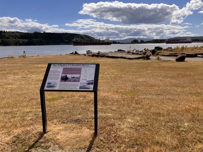
The Mighty Columbia River

Photographed by Barry Swackhamer, June 10, 2026
1. The Mighty Columbia River Marker
captions: (lower left) Mouth of the Columbia River, 1929; (middle right) Fishing for Salmon on the Columbia; (bottom right) Salmon fishing platform constructed of wood along the Columbia River in The Dalles. Oregon; (side-bar) Railroad along the Columbia River. An old cannery building (left) at the Port of Kelso, 1926.
Navigating the Channel
The Columbia River is one of the greatest natural resources in the western United States. It is a dynamic waterway that has a complex diking system and a deep-draft navigation channel. For centuries, the river has provided a significant international and domestic trade route and has opened the door for opportunity and prosperity in the Pacific Northwest.
By the 1820s, ships were plying the Columbia River regularly to supply trading posts on the lower river. As ships became heavier and made there way through the river more frequently dredging became necessary in order to maintain the channel depth and support navigation even at normal to low flows.
The Rivers and Harbors Act of 1878 authorized a navigation channel with a depth of 20 feet in the Columbia and Lower Willamette Rivers. The authorized depth was increased in 1912 to 30 feet, in 1930 to 35 feet and again in 1962 to 40 feet with an authorized width of 600 feet. The
this page online
More Than A River
For thousands of years, the Columbia River has been central to the lives of the Native Americans who lived along its shoreline. The river served as a critical food source, providing an abundance of fish to support indigenous peoples. Fish in the Columbia River included steelhead trout, sturgeon, and lamprey, but the most important for tribes were the species of salmon. Indigenous communities caught fish by using spears and dip nets near the rivers mainstream and its major tributaries. Dried and pounded salmon was a sustaining food and an important trade item for tribes on the Columbia River. By the mid-twentieth century, Indigenous anglers used over 400 fishing platforms at Celilo Falls, in Oregon, to catch migrating fish.
Salmon have long been the symbol and lifeblood of the peoples of the Pacific Northwest and the Columbia River has been integral to native spirituality. Traditional, spiritual ceremonies were observed by most of the tribes, honoring the
Photographed by Barry Swackhamer, June 10, 2026
2. The Mighty Columbia River Marker
(side-bar)
Trade and Industrialization
The Columbia River has been a corridor for commerce, trade, and transportation in the Pacific Northwest for centuries. Before the first Euro-American explorers arrived in the Columbia River Basin, there were Indigenous tribes that lived, hunted, fished, and traded throughout the region. As British and American fur companies entered the basin, they frequently traded with Chinookan peoples. In the 1800s, transportation improved alongside the river and trade to agriculture snd mining. When the transcontinental railroad lines arrived, trade through the region boomed and agricultural production soared.
Fishing also contributed to the industrialization of the Columbia River. Canneries began in develop long the lower river encouraging major economic growth in the Pacific Northwest. By the 1880's, more than thirty fish-canning factories lined the river from Astoria, Oregon, through the Columbia River Gorge producing over 600,000 cases of packed salmon each year.
Topics. This historical marker is listed in this topic list: Waterways & Vessels.
Location. 46° 10.612′ N, 123° 5.802′ W. Marker is near Longview, Washington, in Cowlitz County. It can be reached from Willow Grove Road, on the right when traveling south. The marker is located in Willow Grove Park on Willow Grove Island. Touch for map. Marker is at or near this postal address: 1700 Willow Grove Road, Longview WA 98632, United States of America. Touch for directions.

Regionally, this marker is in Southwest Washington State. It is also on the American Pacific Coast, in the Pacific Northwest, and in the Lewis & Clark Corridor. Globally, it is in North America, on the Ring of Fire, on the Pacific Rim, in the Western Hemisphere, in the Western World, and in the Anglosphere.
Other nearby markers. At least 8 other markers are within 10 miles of this marker, measured as the crow flies: The Cowlitz Indian Tribe (approx. 0.2 miles away); "bold rockey Shore" (approx. 5.9 miles away); "Janey & Pomp" (approx. 7.4 miles away); Mary Richardson Walker (approx. 8 miles away); Public Library (approx. 8 miles away); To the memory of (approx. 9.2 miles away); Oregon Trail (approx. 9.3 miles away); 1852 Monticello Convention (approx. 9.8 miles away). Touch for a list and map of all markers in Longview.
Other markers no longer nearby. Robert A. Long (was approx. 8 miles away but has been permanently removed); The Monticello Convention held here, 1852 (was approx. 8 miles away but has been confirmed missing).
Credits. This page was last revised on August 24, 2026. It was originally submitted on August 24, 2026, by Barry Swackhamer of Brentwood, California. This page has been viewed 15 times since then. Photos: 1, 2. submitted on August 24, 2026, by Barry Swackhamer of Brentwood, California.
