Southwest Portland in Multnomah County, Oregon — The American West (Northwest)
The Great Plank Road

Photographed by Ian Lefkowitz, June 26, 2026
1. The Great Plank Road Marker
Erected 1960 by Lang Syne Society.
Topics and series. This historical marker is listed in this topic list: Roads & Vehicles. In addition, it is included in the Oregon, Lang Syne Society of Portland series list. A significant historical month for this entry is September 1851.
Location. 45° 30.946′ N, 122° 40.982′ W. Marker is in Portland, Oregon, in Multnomah County. It is in Southwest Portland. It can be reached from the intersection of Southwest Jefferson Street and Southwest Park Avenue, on the right when traveling west. Touch for map. Marker is at or near this postal address: 901 SW Jefferson Street, Portland OR 97201, United States of America. Touch for directions.

Regionally, this marker is in the Columbia River Gorge and in the Willamette Valley. It is also on the American Pacific Coast, in the Pacific Northwest, and in the Lewis & Clark Corridor. Globally,
this page online
Other nearby markers. At least 8 other markers are within walking distance of this marker: Theodore Roosevelt (within shouting distance of this marker); Peace Plaza (within shouting distance of this marker); Charles A. Sprague (within shouting distance of this marker); The Washington Ellipse (within shouting distance of this marker); The First Congregational Church of Portland (about 300 feet away, measured in a direct line); Lincoln Bicentennial (about 400 feet away); The Shemanski Fountain (about 700 feet away); Oklahoma City Bombing Memorial (about 700 feet away). Touch for a list and map of all markers in Portland.
Also see . . . Great Plank Road (Tyler Wayne, Oregon Encyclopedia).
Construction was simple. Relatively light 'sleepers' or 'stringers' were laid along the route of the road in two parallel rows about four feet apart. Planks, eight feet long and three or four inches thick, were laid across the stringers and spiked into place (if spikes were scarce, they could be(Submitted on August 24, 2026, by Ian Lefkowitz of New York, New York.)held in place by dirt piled at each end).Photographed by Ian Lefkowitz, June 26, 20262. The Great Plank Road MarkerThe marker is located centrally on the South Park Blocks, facing Southwest Jefferson Street.

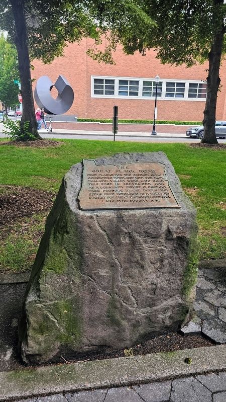
Photographed by Ian Lefkowitz, June 26, 2026
3. The Great Plank Road Marker
The marker affixed to its plinth.
Credits. This page was last revised on August 26, 2026. It was originally submitted on August 24, 2026, by Ian Lefkowitz of New York, New York. This page has been viewed 24 times since then. Photos: 1, 2, 3. submitted on August 24, 2026, by Ian Lefkowitz of New York, New York. • Andrew Ruppenstein was the editor who published this page.
