Port Republic in Rockingham County, Virginia — The American South (Mid-Atlantic)
Winder's Attack
“Here Was the Place to Try Mens Souls”
| — | The Battle of Port Republic (June 9, 1862) | — |
Photographed by Jay Richardson, August 22, 2026
1. Winder's Attack Marker
Morning
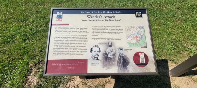
Shortly after Confederate Gen. Charles Winder’s first advance was forced back by Union cannon on the Coaling, Gen. Richard Taylor’s Louisiana brigade arrived to reinforce the southern ranks. Stonewall Jackson ordered the bulk of the Louisianans to attack the Coaling, and Taylor started his men on a circuitous route through the woods to your left to assail the height.
But to increase the chances of that attack’s success, it was important that Winder keep the Federals focused on the plain in front of you. The 7th Louisiana, one of Taylor’s brigades, was sent to reinforce Winder and the 5th Virginia and 27th Virginia. The combined force moved forward, from your left to the right, over the open ground you see across the road. They came under punishing fire from Union infantry to their front and the roaring cannon atop the Coaling—“one incessant storm of… canister and shell.” Despite that ordeal, they continued across the wheatfields until they reached a zig-zagging “worm” fence that ran to your front, just 250 yards in front of the Union position. (See map.) There the Federals unleashed a devastating volley
this page online
“We heard a tremendous yell arise in our fron[t]… [we] saw rise up over a hill a rebel brigade… they poured a volley into our ranks when we without delay returned the compliment… Here was the place to try mens souls.” — Union Sgt. John Hadley, 7th Indiana, recalling Winder’s attack (Spelling from original)
The 27th Virginia initially advanced beyond the fence, yelling like demons, but were forced to pull back to the fence line. For the next half hour, the two sides traded volleys in a murderous, brutal exchange of gunfire. There, on the ground to your right, Confederate Col. Henry Kelly recalled that “the battle was fought with a courage and pertinacity on both sides not surpassed on any field of the war.” More than 550 men fell.
As the Confederate casualties mounted, and their ammunition ran low, they began to give way and fall back through the wheatfield.
(captions)
Confederate Col. Harry T. Hays, commander of the 7th Louisiana. Library of Congress
Confederate Col. Charles DeChoiseul was mortally wounded by a bullet to the chest and died 10 days later. Library of Congress
Union Col. William R. Creighton commanded the 7th Ohio at Port Republic. He was killed at the Battle of Ringgold Gap, Georgia, in 1863.
Cell Phone Tour Info
Dial Up History
540.755.4782 or scan the QR
Erected 2026
Photographed by Jay Richardson, August 22, 2026
2. Port Republic Battlefield
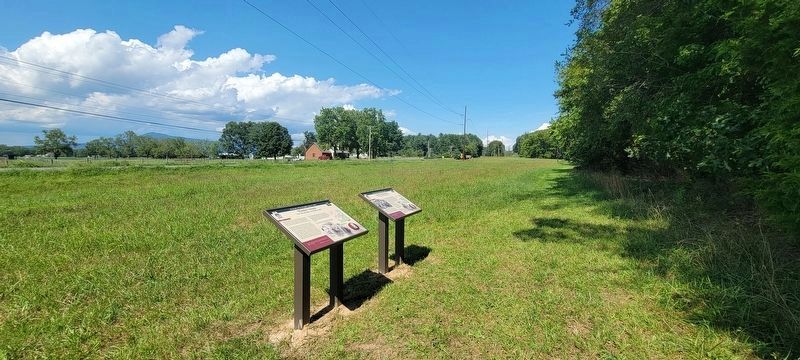
Winder's Attack marker is on the left.
Topics. This historical marker is listed in this topic list: War, US Civil. A significant historical date for this entry is June 9, 1862.
Location. 38° 18.014′ N, 78° 46.217′ W. Marker is in Port Republic, Virginia, in Rockingham County. It is on South East Side Highway (U.S. 340) south of Ore Bank Road, on the right when traveling north. This marker is located along River Plains Walking Trail on the Port Republic Battlefield, accessible from the trailhead at Port Republic and Ore Bank roads. Touch for map. Marker is in this post office area: Port Republic VA 24471, United States of America. Touch for directions.

Regionally, this marker is in the Shenandoah Valley. It is also in the American South and specifically in the Upper South. Globally, it is in North America, the Western Hemisphere, the Western World, and the Anglosphere. Historically, it finds itself in what was once the territory of the Mississippian Culture, one of the original Thirteen Colonies, one of the Confederate States of America, and the Antebellum South.
Other nearby markers. At least 8 other markers are within walking
Photographed by Jay Richardson, August 22, 2026
3. River Plains Walking Trail
Credits. This page was last revised on August 31, 2026. It was originally submitted on August 27, 2026, by Jay Richardson of Winchester, Virginia. This page has been viewed 14 times since then. Photos: 1, 2, 3. submitted on August 27, 2026, by Jay Richardson of Winchester, Virginia. • Bernard Fisher was the editor who published this page.
