Hilton Beach in Algoma District, Ontario — Central Canada (North America)
Fort St. Joseph
| — | Fort Saint Joseph National Historic Site | — |

Photographed by Cosmos Mariner, June 10, 2024
1. Fort St. Joseph Marker

The British fort was built in 1796, and was once referred to as “Siberia” by the soldiers. It was the most western fort defending the British colony from American invasion. To the soldiers it was isolated, with unfamiliar territory beyond this point.
The First Nations and voyageurs had a different perspective. To them, St. Joseph Island was a regular sight on a major east-west trade route. Beyond this point were family, friends and trading partners.
Soldiers, Indigenous Peoples and voyageurs would join together here at Fort St. Joseph to launch one of the first strikes in the War of 1812.
Explore the ruins of Fort St. Joseph. Along the way we will tell you the story of who lived here, how they lived and what happened when they attacked the Americans.
Fort St. Joseph National Historic Site
• Path around the ruins — easy walk, 1 km (1/2 mile) loop.[image captions]
• Please help us take care of the ruins by not disturbing them.
• This is an archaeological site, so nothing can be removed.
• 1744 Map of St. Joseph Island with canoe route overlay [Library and Archives Canada c084259]
• 1812 era Great Lakes Forts [Parks Canada]
• “View of the Post of St. Joseph at the Head of Lake Huron,” 1804, Edward Walsh. [William L. Clements Library, University of Michigan]
Construit en 1796, le fort britannique était anciennement qualifié de « Sibérie » par les soldats. Parmi les forts défendant la colonie britannique contre l'invasion
this page online
Les Premières Nations et les voyageurs ne partageaient pas cet avis. Pour eux, l'île St. Joseph constituait un élément familier. Le long d'une importante route commerciale liant l'est à l'ouest et au-delà de celle-ci, se trouvaient des membres de leur famille, des amis et des partenaires commerciaux.
C'est au fort St. Joseph que se sont réunis les soldats, les Autochtones et les voyageurs qui ont mené l'une des premières attaques lors de la guerre de 1812.
Explorez les ruines du fort St. Joseph. Tout au long de votre parcours, vous découvrirez l'histoire et la mode de vie des habitants de ce lieu, et vous apprendrez ce qui s'est passé lorsqu'ils ont lancé une attaque contre les Américains.
Lieu historique national du Fort-St. Joseph
• Sentier autour des ruines : boucle de 1 km (facile à parcourir).[légendes d'images]
• Pour nous aider à conserver les ruines, ne les déplacez pas.
• Vous vous trouvez sur un site archéologique; aucun élément ne peut donc en être retiré.
• Carte (datant
Courtesy Parks Canada
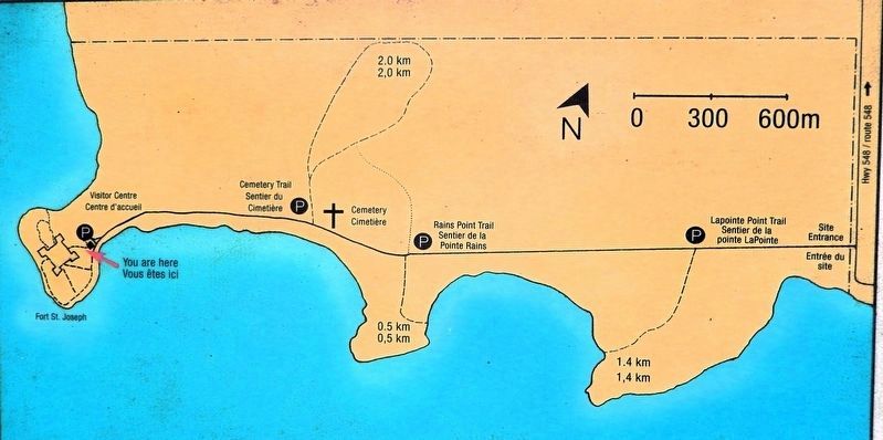
2. Marker detail: Fort St. Joseph NHS Site Map / Carte du LHN du Fort-St. Joseph
• Forts des Grands Lacs datant de 1812 [Parcs Canada]
• « Image du poste de St. Joseph, à la tête du lac Huron », 1804, Edward Walsh [William L. Clements Library, Université du Michigan]
Erected by Parks Canada / Parcs Canada.
Topics. This historical marker is listed in these topic lists: Forts and Castles • Indigenous Peoples and Communities • Industry & Commerce • War of 1812. A significant historical year for this entry is 1796.
Location. 46° 3.849′ N, 83° 56.724′ W. Marker is in Hilton Beach, Ontario, in Algoma District. It can be reached from Fort Road 4.8 kilometers west of A Line Road. The marker is on the Fort St. Joseph National Historic Site interpretive trail, just south of the Visitor Center. Touch for map. Marker is at or near this postal address: 185 Fort Road, Hilton Beach ON P0R 1G0, Canada. Touch for directions.

Regionally, this marker is in the Sault Ste. Marie and Algoma Area and in Northern Ontario. It is also in Central Canada. Globally, it is in North America, in the

Photographed by Cosmos Mariner, June 10, 2024
3. Fort St. Joseph Marker
Looking southwest along the Fort St. Joseph National Historic Site interpretive trail. The historic fort ruins are beyond the trees in the distance.
Other nearby markers. At least 8 other markers are within walking distance of this marker: Fort St. Joseph / Le Fort Saint-Joseph (within shouting distance of this marker); Major Intersection/Une intersection importante (about 90 meters away, measured in a direct line); Inside the Walls/À l'intérieur des remparts (about 90 meters away); Land of Little Comfort / Un Territoire offrant peu de confort (about 120 meters away); Build it Better/Une construction améliorée (about 120 meters away); Want to be a Soldier?/Vous voulez être un soldat? (about 120 meters away); The Importance of Friends/L'importance des amis (about 150 meters away); Black Hole or Flogging/Le trou noir, ou le fouet? (about 150 meters away). Touch for a list and map of all markers in Hilton Beach.
Related markers. Click here for a list of markers that are

Photographed by Cosmos Mariner, June 10, 2024
4. Fort Saint Joseph Model
Also see . . . Fort St. Joseph National Historic Site (Parks Canada).
Excerpt: Explore the ruins of Fort St. Joseph National Historic Site and feel the rich War of 1812 history that lingers – a history that saw a powerful alliance struck between the British and the First Nations People of the western Great Lakes region. Hike to Lake Huron’s edge, experience history through heritage demonstrations, watch for more than 200 species of birds, and view authentic artifacts from the old fort.(Submitted on August 30, 2026, by Cosmos Mariner of Cape Canaveral, Florida.)

Photographed by Cosmos Mariner, June 10, 2024
5. Fort Saint Joseph Blockhouse Ruins
Credits. This page was last revised on September 1, 2026. It was originally submitted on August 29, 2026, by Cosmos Mariner of Cape Canaveral, Florida. This page has been viewed 16 times since then. Photos: 1, 2, 3. submitted on August 30, 2026, by Cosmos Mariner of Cape Canaveral, Florida. 4, 5. submitted on September 1, 2026, by Cosmos Mariner of Cape Canaveral, Florida.
