Hudgins in Mathews County, Virginia — The American South (Mid-Atlantic)
Battle of Cricket Hill
Lord Dunmore's Last Stand
| — | Road to Revolution | — |
Photographed by Evan Dwyer, August 29, 2026
1. Battle of Cricket Hill Marker
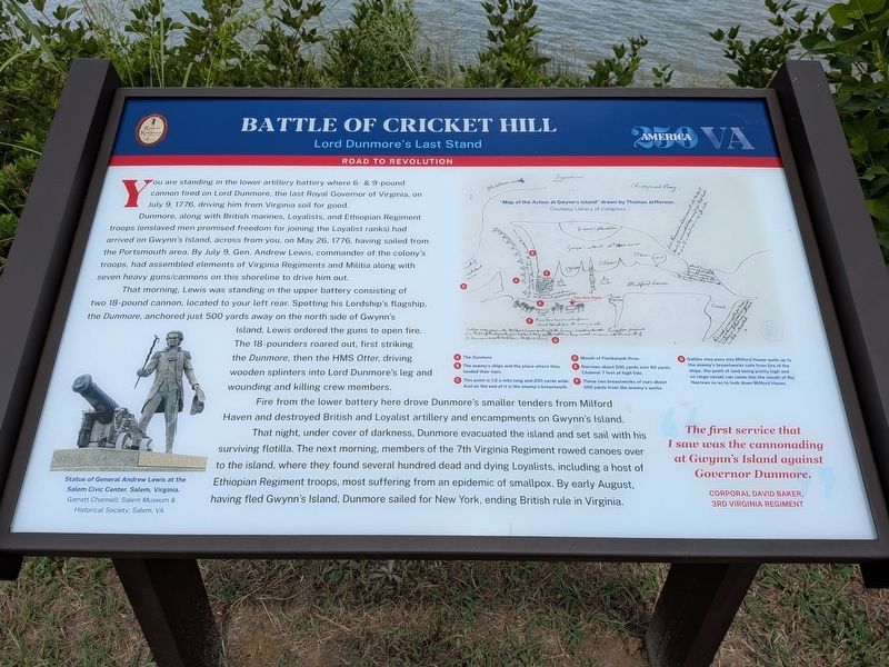
Dunmore, along with British marines, Loyalists, and Ethiopian Regiment troops (enslaved men promised freedom for joining the Loyalist ranks) had arrived on Gwynn's Island, across from you, on May 26, 1776, having sailed from the Portsmouth area. By July 9, Gen. Andrew Lewis, commander of the colony's troops, had assembled elements of Virginia Regiments and Militia along with seven heavy guns/cannons on this shoreline to drive him out.
That morning, Lewis was standing in the upper battery consisting of two 18-pound cannon, located to your left rear. Spotting his Lordship's flagship, the Dunmore, anchored just 500 yards away on the north side of Gwynn's Island, Lewis ordered the guns to open fire. The 18-pounders roared out, first striking the Dunmore, then HMS Otter, driving wooden splinters into Lord Dunmore's leg and wounding and killing crew members.
Fire from the lower battery here drove Dunmore's smaller tenders from Milford
this page online
That night, under cover of darkness, Dunmore evacuated the island and set sail with his surviving flotilla. The next morning, members of the 7th Virginia Regiment rowed canoes over to the island, where they found several hundred dead and dying Loyalists, including a host of Ethiopian Regiment troops, most suffering from an epidemic of smallpox. By early August, having fled Gwynn's Island, Dunmore sailed for New York, ending British rule in Virginia.
"The first service that I saw was the cannonading at Gwynn's Island against Governor Dunmore."
Corporal David Baker, 3rd Virginia Regiment
Map Key/Captions:
A - The Dunmore
B - The enemy's ships and the place where they landed their men.
C - This point is 1/2 a mile long and 200 yards wide. And on the end of it is the enemy's breastwork.
D - Mouth of Piankatank River
E - Narrows about 200 yards over 60 yards. Channel 7 feet at high tide.
F - These two breastworks of ours about 500 yards from the enemy's works.
G - Gallies may pass into Milford Haven quite up to the enemy's breastworks safe from fire of the ships, the point of land being pretty high and no large vessel can come into the mouth of the Narrows so as to look down Milford Haven.
Photo Caption:
Statue of General Andrew Lewis at the Salem Civic Center, Salem, Virginia.
Garrett Channell; Salem Museum & Historical Society; Salem, VA
Erected by Road
Photographed by Evan Dwyer, August 29, 2026
2. Battle of Cricket Hill Marker
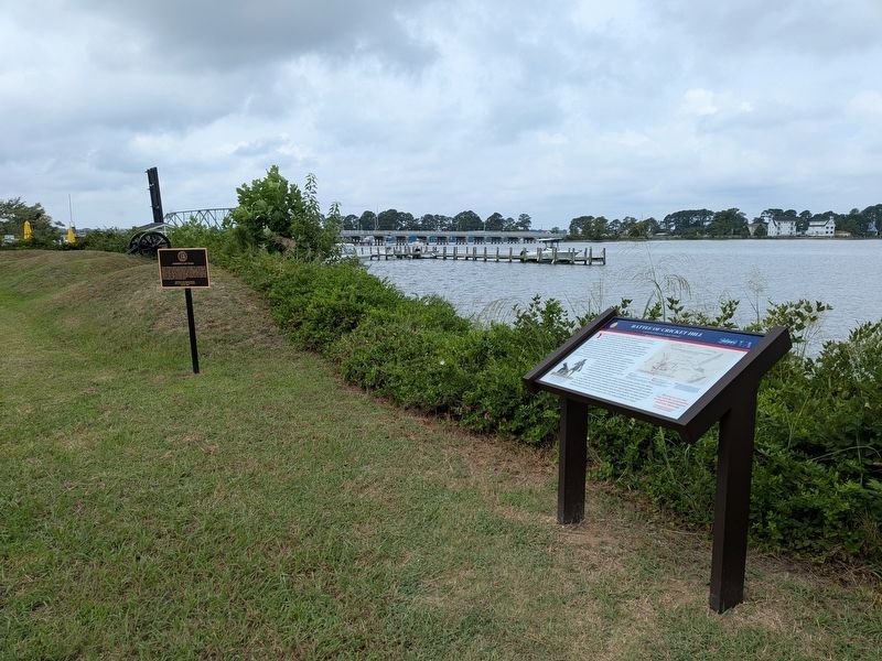
The earthworks beyond the marker are the Revolutionary War traces of the 9-pounder gun positions.
Topics and series. This historical marker is listed in these topic lists: Colonial Era • Forts and Castles • Patriots & Patriotism • War, US Revolutionary. In addition, it is included in the Road to Revolution Heritage Trail series list. A significant historical date for this entry is July 9, 1776.
Location. 37° 29.297′ N, 76° 18.434′ W. Marker is in Hudgins, Virginia, in Mathews County. It can be reached from Mill Point Road (Virginia Route 669) 0.2 miles north of Cricket Hill Road ( Route 223), on the left when traveling east. Marker is on the footpath between Morningstar Marinas and Milford Haven. Touch for map. Marker is at or near this postal address: 249 Mill Point Road, Hudgins VA 23076, United States of America. Touch for directions.

Regionally, this marker is on the Middle Peninsula and in the Hampton Roads Metropolitan Area. It is also in the American South, specifically in the Upper South, in the Tidewater, in the Chesapeake Bay Region, and on the Eastern Seaboard. Globally, it is in the North Atlantic Region, North America, the Western Hemisphere, the Western World, and the
Photographed by Evan Dwyer, August 29, 2026
3. Cricket Hill Earthworks
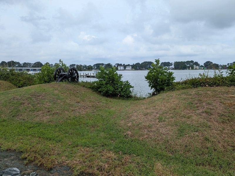
View of one of the eroded gun embrasures. The little cannon on top of the traverse mound is a lawn ornament, not a replica. The guns would have been between the traverses, not on top of them. Of note, the target for the Virginia troops manning this position on 9 July 1776 is the spit of land off to the left, at the southwest edge of Gwynn's Island, where Lord Dunmore's primary encampment was within then-Fort Hamond.
Other nearby markers. At least 8 other markers are within 4 miles of this marker, measured as the crow flies: Dunmore's Last Stand (here, next to this marker); Captain Louis d'Ohicky Arundel (a few steps from this marker); a different marker also named Battle of Cricket Hill (approx. 0.2 miles away); By Duty Done Is Honor Won (approx. 1½ miles away); Black Exodus from Gwynn's Island (approx. 2.8 miles away); Flights to Freedom (approx. 2.8 miles away); Fitchett's Wharf (approx. 3.2 miles away); Veterans Memorial (approx. 3.4 miles away). Touch for a list and map of all markers in Hudgins.
Also see . . . Fort Cricket Hill Historic Register Entry. Virginia Department of Historic Resources State & National Places/Landmarks Register with nomination form describing significance of the site and event. (Submitted on August 30, 2026, by Evan Dwyer of Richmond, Virginia.)

Photographed by Evan Dwyer, August 29, 2026
4. Battle of Cricket Hill Marker
View of the pathway, marker, and earthworks. Both of the metal tablet markers flanking the Road to Revolution marker are related to the Cricket Hill battle as well.
Photographed by Evan Dwyer, circa August 2026
5. Fort Cricket Hill
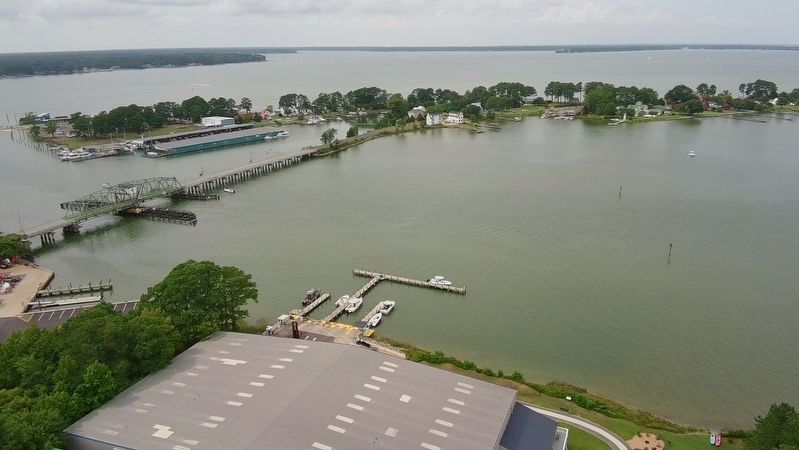
Recreational Drone view. The remaining earthworks of "Fort Cricket Hill" are visible at lower center just in front of the marina's storage building. Their target was the camp and fort (no longer extant) on the southwest corner of Gwynn's Island just to the left of the bridge, opposite the narrow channel. The range, even for cannon of that era, was very short.
Credits. This page was last revised on August 31, 2026. It was originally submitted on August 30, 2026, by Evan Dwyer of Richmond, Virginia. This page has been viewed 23 times since then. Photos: 1, 2, 3, 4, 5. submitted on August 30, 2026, by Evan Dwyer of Richmond, Virginia.
