
Prince Rupert in North Coast, British Columbia — Canada’s West Coast (North America)
Former Federal Building/City Hall
Est. 1939
Photographed by Bradley Owen, August 14, 2026
1. Former Federal Building/City Hall Marker
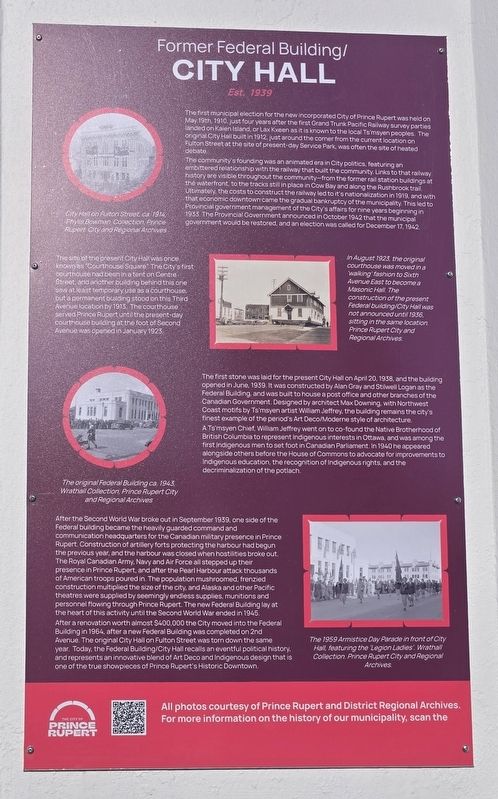
The first municipal election for the new incorporated City of Prince Rupert was held on May 19th, 1910, just four years after the first Grand Trunk Pacific Railway survey parties landed on Kaien Island, or Lax Kxeen as it is known to the local Ts'msyen peoples. The original City Hall built in 1912, just around the corner from the current location on Fulton Street at the site of present-day Service Park, was often the site of heated debate.
The community's founding was an animated era in City politics, featuring an embittered relationship with the railway that built the community. Links to that railway history are visible throughout the community-from the former rail station buildings at the waterfront, to the tracks still in place in Cow Bay and along the Rushbrook trail. Ultimately, the costs to construct the railway led to it's nationalization in 1919, and with that economic downtown came the gradual bankruptcy of the municipality. This led to Provincial government management of the City's affairs for nine years beginning in 1933. The Provincial Government announced in October 1942 that the municipal government would be restored, and an election was called for December 17, 1942.
The site of the present City Hall was once known as "Courthouse Square". The City's first courthouse had been in a tent on Centre Street, and another building behind this one saw at least temporary use as a courthouse, but a permanent building stood on this Third Avenue location by 1913. The courthouse served Prince Rupert until the present-day courthouse building at the foot of Second Avenue was opened in January 1923.
The first stone was laid for the present City Hall on April 20, 1938, and the building opened in June, 1939. It was constructed by Alan Gray and Stilwell Logan as the Federal Building, and was built to house
this page online
A Ts'msyen Chief, William Jeffrey went on to co-found the Native Brotherhood of British Columbia to represent Indigenous interests in Ottawa, and was among the first Indigenous men to set foot in Canadian Parliament. In 1940 he appeared alongside others before the House of Commons to advocate for improvements to Indigenous education, the recognition of Indigenous rights, and the decriminalization of the potlach.
After the Second World War broke out in September 1939, one side of the Federal building became the heavily guarded command and communication headquarters for the Canadian military presence in Prince Rupert. Construction of artillery forts protecting the harbour had begun the previous year, and the harbour was closed when hostilities broke out. The Royal Canadian Army, Navy and Air Force all stepped up their presence in Prince Rupert, and after the Pearl Harbour
Photographed by Bradley Owen, August 14, 2026
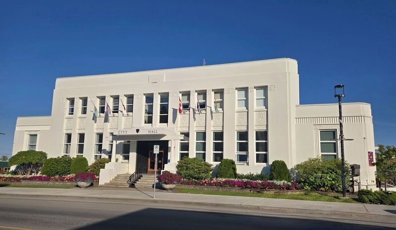
2. Former Federal Building/City Hall and Marker
The marker is located at the far right edge of the building.
After a renovation worth almost $400,000 the City moved into the Federal Building in 1964, after a new Federal Building was completed on 2nd Avenue. The original City Hall on Fulton Street was torn down the same year. Today, the Federal Building/City Hall recalls an eventful political history, and represents an innovative blend of Art Deco and Indigenous design that is one of the true showpieces of Prince Rupert's Historic Downtown.
(Captions):
City Hall on Fulton Street ca. 1914, Phylis Bowman Collection. Prince Rupert City and Regional Archives
In August 1923, the original courthouse was moved in a 'walking' fashion to Sixth Avenue East to become a Masonic Hall. The construction of the present Federal building/City Hall was not announced until 1936, sitting in the same location.
Prince Rupert City and Regional Archives.
The original Federal Building ca. 1943, Wrathall Collection. Prince Rupert City and Regional Archives
The 1959 Armistice Day Parade in front of City Hall, featuring the 'Legion Ladies'. Wrathall Collection. Prince Rupert City and Regional Archives.
Erected by The City of Prince Rupert, BC.
Topics. This historical marker is listed in these topic lists: Government & Politics • Indigenous Peoples and Communities • Notable Buildings • Railroads & Streetcars. A significant historical date for this entry is May 19, 1910.
Location. 54° 18.763′ N, 130° 19.506′ W. Marker is in Prince Rupert, British Columbia, in North Coast. It is on 3 Avenue West just south of 3 Street, on the right when traveling south. Touch for map. Marker is at or near this postal address: 424 3 Avenue West, Prince Rupert BC V8J 1L3, Canada. Touch for directions.

Regionally, this marker is in Northern BC. Globally, it is in North America, on the Ring of Fire, in the Pacific Rim, in the Western Hemisphere, in the Western World, and in the Anglosphere. Historically, it finds itself in what was once a British colony.
Other nearby markers. At least 8 other markers are within walking distance of this marker: Charles Melville Hays (here, next to this marker); Pillsbury House (approx. 0.3 kilometers away); MacKenzie Furniture Ltd. (approx. 0.3 kilometers away); Mother Grey Whale and Calf (approx. 0.4 kilometers away); Kwinitsa Railway Museum (approx. 0.4 kilometers away); Lieutenant Colonel Cyrus Wesley Peck, VC, DSO & Bar (approx. 0.4 kilometers away); Private Allan Milton Olsen (approx. 0.4 kilometers away); Prince Rupert Cenotaph (approx. 0.4 kilometers away). Touch for a list and map of all markers in Prince Rupert.
Credits. This page was last revised on September 3, 2026. It was originally submitted on September 3, 2026, by Bradley Owen of Morgantown, West Virginia. This page has been viewed 5 times since then. Photos: 1, 2. submitted on September 3, 2026, by Bradley Owen of Morgantown, West Virginia.
