Basingstoke in Hampshire, England, United Kingdom — Northwestern Europe (the British Isles)
The Basing Trail
Photographed by Ray Gurganus, May 21, 2026
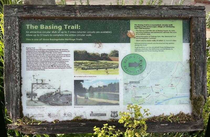
1. The Basing Trail Marker
Basing Trail
This trail leads from the centre of Basingstoke through attractive parkland to local countryside where Basing House a fascinating site, all but destroyed in the English Civil War, can be visited.
To follow this trail follow the waymark arrows, located on lampposts and street furniture, to arrive at Eastrop Park where you can choose which route to follow to reach the village of Old Basing.
For the most direct route you must walk past the lakes and river Eastrop Park before crossing Basing Fen to come to Basing House, the historic English Civil War site on the fringes of Old Basing.
Alternatively in the other direction you walk up a road to the Civic Offices, pass in front of them to enter the War Memorial Park, then on to Black Dam ponds, Crabtree Plantation and Basingstoke Common before arriving at Old Basing.
The Basing Trail is a waymarked, circular walk leading to the picturesque village of Old Basing. This Trail features:
•
this page online
• Attractive parks of Eastrop Park, War Memorial Park and Basingstoke Common.
• Short cuts to create walks of either 2, 3 or 4.5 miles
Interpretation panels are located at key points along the trail.
Trail leaflets can be obtained from Basingstoke railway station, the Millstone public house in Old Basing and from Basing House.
Topics. This historical marker is listed in this topic list: Parks & Recreational Areas.
Location. 51° 16.088′ N, 1° 5.246′ W. Marker is in Basingstoke, England, in Hampshire. It is on Alençon Link. The marker is located in front of the Basingstoke railway station. Touch for map. Marker is at or near this postal address: 145 Alençon Link, Basingstoke, England RG21 7TW, United Kingdom. Touch for directions.

Regionally, this marker is in the Greater South East. Globally, it is on the Atlantic Ocean, in the North Atlantic Region, in Europe, in Atlantic Europe, on one of the British Isles, in the Western World, and in the Anglosphere. Historically, it finds itself in what was once the Roman Empire.
Other nearby markers. At least 8 other markers are within 11 kilometers of this marker, measured as the crow flies: Welcome to the Holy Ghost Cemetery (about 180 meters away, measured in a direct line); Holy Ghost Cemetery (approx. 0.3 kilometers away); Methodist Church (approx. 0.3 kilometers away); a different marker also named Welcome to the Holy Ghost Cemetery (approx. 0.3 kilometers away); Remembrance Garden (approx. 0.4 kilometers away); John Curwen (approx. 0.6 kilometers away); D Day Landings (approx. 0.7 kilometers away); Calleva Atrebatum - A Roman Town (approx. 9.8 kilometers away). Touch for a list and map of all markers in Basingstoke.
Credits. This page was last revised on September 16, 2026. It was originally submitted on September 15, 2026, by Ray Gurganus of Washington, District of Columbia. This page has been viewed 6 times since then. Photo 1. submitted on September 15, 2026, by Ray Gurganus of Washington, District of Columbia. • Andrew Ruppenstein was the editor who published this page.
