Pitt Township in Morral in Wyandot County, Ohio — The American Midwest (Great Lakes)
to Fort Morrow
⎯⎯⎯
to Fort Ferree
Ohio's Revolutionary Memorial Trail
| — | Harrison's March 1813 | — |

Image courtesy of the Historical Marker Database
1. to Fort Morrow / to Fort Ferree Marker
Revolutionary
Memorial
Trail
- - - - -
24
Miles to
Fort
Morrow
- - - - -
8
Miles to
Fort
Ferree
Erected 1930 by Ohio Revolutionary Memorial Commission. (Marker Number A147.)
Topics and series. This historical marker is listed in these topic lists: Forts and Castles • Roads & Vehicles • War of 1812. In addition, it is included in the Ohio Revolutionary Memorial Commission series list. A significant historical year for this entry is 1813.
Location. Marker has been permanently removed. It was located near 40° 43.897′ N, 83° 12.106′ W. Marker was in Morral, Ohio, in Wyandot County. It was in Pitt Township. It was on County Route 113 south of County Route 126, on the right when traveling south. Nothing remains of this marker, but according to my vehicle's odometer this marker site is exactly 8.0 miles south of the Ohio Revolutionary Memorial Commission marker for Fort Ferree. However, the fact that most of the 1930 era, US 23, roadway has been altered in Wyandot County has complicated my efforts to determine the probable location of this missing marker. Touch for map. Marker was in this post office area: Morral OH 43337, United States of America.
We have been informed that this marker is no longer there and will not be replaced. This page is an archival view of what was.
Regionally, this marker was in the Till Plains. It was also in the American Midwest and in the Corn Belt. Globally, it was in North America, the Western Hemisphere, the Western World, and the Anglosphere. Historically, it found itself in what was once the Viceroyalty of New France, the Haudenosaunee (Iroquois) Confederacy, the territory of the Mississippian Culture, and the Northwest Territory.

Other nearby markers. At least 8 other markers
this page online
More about this marker. This historical marker is part of the Ohio Revolutionary Memorial Trail series (type A) which was put in place in 1930 to celebrate the 150th anniversary of the Ohio's Revolutionary War era Battle of Piqua, by the Ohio Revolutionary Memorial Commission.
In order to accomplish this, in 1929 the state of Ohio created the Ohio Revolutionary Memorial Commission, and then in 1930 this commission created 22 military trails, throughout western Ohio, between Cincinnati, Ohio on the state's southern border and Toledo, Ohio on the state's northern border. Each of these military trails represented the routes, or trails, used by military
Photographed by Dale K. Benington, May 4, 2016
2. to Fort Morrow / to Fort Ferree Marker
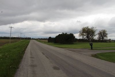
View, looking north along County Route 115, of the probable site of the missing marker. I used the roadside mailbox as a reference point for the probable location of the marker.
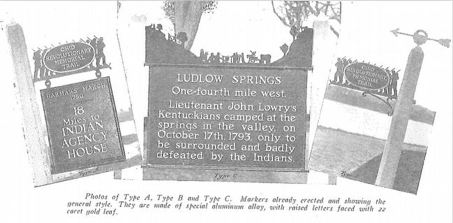
The routes of these military trails were in turn marked by type A and type B Ohio Revolutionary Memorial Commission markers that served as directional (type B) and distance (type A) markers. This particular marker is one of the type A markers of the Ohio Revolutionary Memorial Trail series.
Originally, back in 1930, according to the ORMC 1931 Planning Report, there were erected 168 some of these Ohio Revolutionary Memorial Commission, type A, markers (see page 54). To date, I know of only 3 of these type A markers that have been located and posted on the Historical Marker database (markers A95, A96, and A1340). A large number of them are presently missing, including this particular marker, A147, which is listed on page 62 of the 1931, Ohio Revolutionary Memorial Commission's Planning Report.
Also see . . . Ohio Revolutionary Memorial Trail System.
Photographed by Dale K. Benington, May 4, 2016
3. to Fort Morrow / to Fort Ferree Marker
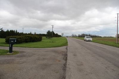
View, looking south along County Route 115, of the probable site of the missing marker. I used the roadside mailbox as a reference point for the probable location of the marker.
Additional commentary.
1. Ohio Revolutionary Memorial Trail System Markers
This particular Ohio Revolutionary Memorial Commission (ORMC), Type A marker, once helped to mark the military marches of General Harrison during the War of 1812. According to the ORMC 1931 Planning Report (see page 62), it was used on the portion of the Ohio Revolutionary Memorial Trail System that connected Upper Sandusky to Marion. According to the Ohio Revolutionary Memorial Trails cartographic map, that was issued by the ORMC in 1930, this marker was situated along the roadway that in 1930 was US 23, but today, in this particular location, it is County Route 113.
Along some portions of the Ohio Revolutionary Memorial Trail System, it is difficult to identify the probable location of these markers because the roadways of 1930 are so much different from the present day roadways. Many of the original roadways have been re-routed or by-passed, or in some cases given new route number
Photographed by Dale K. Benington, May 4, 2016
4. to Fort Morrow / to Fort Ferree Marker
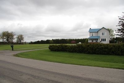
View of the probable site of the missing marker, along County Route 115. I used the roadside mailbox as a reference point for the probable location of the marker, in front of the blue roofed farmhouse.
So in order to locate the probable location of this particular marker I had to first determine which roadways, through Wyandot County, were part of the 1930 era US 23. Fortunately, however, I had the help of Wyandot County Commissioner, Bill Clinger, who as a child use to travel with his parents along the old US 23, from their farm in Marion County, to visit with his grandmother in Wyandot County. So with his help I was able to follow the original roadways, from Upper Sandusky, to the probable site of this marker.
Unfortunately, today there is no physical evidence that would indicate exactly where this particular missing marker was situated along this rural roadway, that parallels modern day US 23 in this location.
— Submitted May 9, 2016, by Dale K. Benington of Toledo, Ohio.
Photographed by Ohio Revolutionary Memorial Commission
5. Ohio Revolutionary Memorial Commission Marker Types
View of the three types of markers used by the Ohio Revolutionary Memorial Commission. The marker on the left is a type A marker (just like our missing marker), the marker in the middle is a type C, and the marker on the right is a type B.
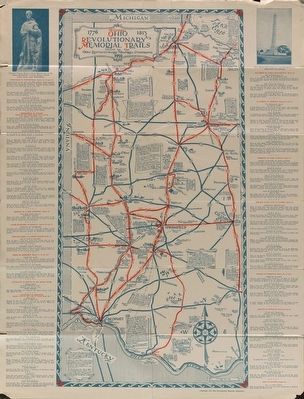
Image courtesy of the MidPointe Library System (www.MidPointeLibrary.org)
6. Ohio Revolutionary Memorial Trail Map
A view of an original Ohio Revolutionary Memorial Trail Map, from 1930. For a better view double click on this picture.
Credits. This page was last revised on September 21, 2026. It was originally submitted on May 9, 2016, by Dale K. Benington of Toledo, Ohio. This page has been viewed 662 times since then and 47 times this year. Last updated on September 18, 2026, by Craig Doda of Napoleon, Ohio. Photos: 1, 2, 3, 4, 5, 6. submitted on May 9, 2016, by Dale K. Benington of Toledo, Ohio. • Devry Becker Jones was the editor who published this page.
