Near Pasco, Washington — The American West (Northwest)
At the Confluence
Photographed by Barry Swackhamer, June 13, 2026
1. At the Confluence Marker
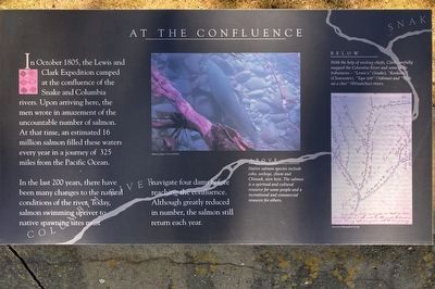
In the last 200 years, there have been many changes to the natural condition of the rivers. Today, salmon swimming upriver to native spawning sites must navigate four dams before reaching the confluence. Although greatly reduced in number, the salmon still return each year.
[Captions]
ABOVE
Native salmon species include coho, sockeye, chum and Chinook, seen here. The salmon is a spiritual and cultural resource for some people and a recreational and commercial resource for others.
BELOW
With the help of visiting chiefs, Clark carefully mapped the Columbia River and some of its tributaries - "Lewis's (Snake), "Kosloske" (Clearwater), "Tape tett" (Yakima) and "Wah na a chee" (Wenatċhee) rivers.
Topics. This historical marker is listed in these topic lists: Exploration • Waterways & Vessels. A significant historical month for this entry is October 1805.
Location. 46° 11.932′ N,
this page online

Regionally, this marker is in the American Lewis & Clark Corridor. Globally, it is in North America, on the Pacific Rim, in the Western Hemisphere, in the Western World, and in the Anglosphere.
Other nearby markers. At least 8 other markers are within walking distance of this marker: Lewis & Clark Camp (a few steps from this marker); Columbia River (within shouting distance of this marker); Snake River (within shouting distance of this marker); Mayor A. P. Gray (within shouting distance of this marker); "Sah-cah-ga-weah" (within shouting distance of this marker); "great Columbia river" (within shouting distance of this marker); Lewis and Clark National Historic Trail (within shouting distance of this marker); Snake River Passage & Columbia Plains Crossing (within shouting distance of this marker). Touch for a list and map
Photographed by Barry Swackhamer, June 13, 2026
2. At the Confluence Marker
Credits. This page was last revised on September 19, 2026. It was originally submitted on September 19, 2026, by Barry Swackhamer of Brentwood, California. This page has been viewed 5 times since then. Photos: 1, 2. submitted on September 19, 2026, by Barry Swackhamer of Brentwood, California.
