Southbank in Melbourne, Victoria, Australia — Oceania
The Turning Basin
| — | Yarra Trail | — |
Photographed by Dean Barton-Ancliffe, August 24, 2026
1. The Turning Basin Marker
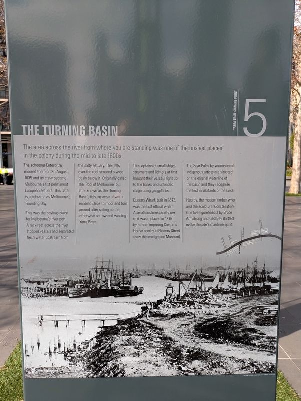
The schooner Enterprize moored there on 30 August, 1835 and its crew became Melbourne's first permanent European settlers. This date is celebrated as Melbourne's Founding Day.
This was the obvious place for Melbourne's river port. A rock reef across the river stopped vessels and separated fresh water upstream from the salty estuary. The 'falls' over the reef scoured a wide basin below it. Originally called the 'Pool of Melbourne' but later known as the 'Turning Basin', this expanse of water enabled ships to moor and turn around after sailing up the otherwise narrow and winding Yarra River.
The captains of small ships, steamers and lighters at first brought their vessels right up to the banks and unloaded cargo using gangplanks.
Queens Wharf, built in 1842, was the first official wharf. A small customs facility next to it was replaced in 1876 by a more imposing Customs House nearby in Flinders Street (now the Immigration Museum).
The Scar Poles by various local indigenous artists
this page online
Nearby, the modern timber wharf and the sculpture 'Constellation' (the five figureheads) by Bruce Armstrong and Geoffrey Bartlett evoke the site's maritime spirit. (Marker Number 5.)
Topics. This historical marker is listed in these topic lists: Colonial Era • Settlements & Settlers. A significant historical date for this entry is August 30, 1835.
Location. 37° 49.273′ S, 144° 57.652′ E. Marker is in Southbank, Victoria, in Melbourne. It is on Queens Bridge Street 0.1 kilometers east of Yarra Promenade, on the left when traveling north. Touch for map. Marker is at or near this postal address: Queens Bridge Street, Southbank VIC 3006, Australia. Touch for directions.

Regionally, it is in Oceania, in Australasia, in the Pacific Ocean, in South Pacific, on the Pacific Rim, in the Western World, and in the Anglosphere. Historically, it finds itself in what was once a British colony.
Other nearby markers. At least 8 other markers are within walking distance of this marker: Australians' History (about 90 meters away, measured in
Photographed by Dean Barton-Ancliffe, August 24, 2026
2. The Marker facing across the river to the Turning Basin
Also see . . . The Turning Basin. Northbank Heritage Trail
This site has a rich history and was significant because of its proximity to the rocky natural weir across the river which formed a natural crossing place. Fresh water spilled over the rocky ridge forming a waterfall (later known as The Falls). This was a traditional meeting place and fishing ground for the Wurundjeri and their neighbours, the Boonwurrung, who used the location as a crossing point between their lands, to trade and negotiate marriages.(Submitted on September 20, 2026, by Dean Barton-Ancliffe of Rowville, Victoria.)
Narrow and shallow, the Birrarung/Yarra frequently flooded, damaging property and livelihoods. To ameliorate this problem, many government-funded public works were devised including destroying The Falls which, to an extent, caused flooding by holding back the upstream floodwaters rushing downstream to Port Phillip Bay. More ambitious works included widening and deepening the river and altering its natural course. European settlers recorded the first major flood in 1839; and the biggest flood in 1891.
The Falls were also an obstacle to ships sailing upstream, but as tidal surges struck The Falls, water swirling back downstream carved a wide pool into the river bank, a natural ‘turning circle’ for vessels to steer out of the river, head back downstream and sail out to Port Phillip Bay. Settlers named this natural turning basin, the ‘Pool of Melbourne’ which, with the rapid influx of settlers and multiple vessels, soon became critical to the fledgling maritime port city. River widening and deepening works accommodated larger ships until in 1930, the new Spencer Street bridge prevented ships from sailing upstream.
Credits. This page was last revised on September 20, 2026. It was originally submitted on September 20, 2026, by Dean Barton-Ancliffe of Rowville, Victoria. This page has been viewed 7 times since then. Photos: 1, 2. submitted on September 20, 2026, by Dean Barton-Ancliffe of Rowville, Victoria. • Andrew Ruppenstein was the editor who published this page.
