Near Prescott in Walla Walla County, Washington — The American West (Northwest)
Dangerous Rapids
Photographed by Barry Swackhamer, June 14, 2026
1. Dangerous Rapids Marker
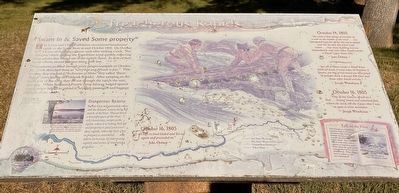
"Swam in & Saved Some Property"
The Lewis and Clark Expedition encountered treacherous rapids on the Snake Rover in mid-October 1805. On October 14, one of the party's canoes sank after striking a rock. Two Nimiipuu chiefs guiding the Expedition acted quickly, collecting many articles that floated out of the sunken canoe. In spite of their heroic efforts, several precious items were lost.
The explorers paddled through more dangerous rapids on October 15. Clark described them as "verry bad and dificuelt to pass." That evening they reached a "Succession of Sholes" they called "Bason Rapids" (later known as Fishhook Rapids). After camping on the north side of the river, they set out through the rapids the next morning. When Nathaniel Pryor's canoe became lodged against a rock others helped to unload it, bringing passengers and baggage safely to shore.
"Dangerous Beauty"
Patrick Gass was particularly taken with the dramatic scenery along this stretch of the River. "Passed down a beautiful part of the river ... very handsome, except at the rapids, where it is risking both life and property to pass; and even these rapids, when the Ban(?) view or prospect is considered ... may add to its beauty, by interposing variety and scenes of romantic grandeur..."
this page online
" the canoe I had charge of ran fast on a rock in the middle of the river ... we attempted to git hir off but the waves dashed over hir So that She filled with water ... two mens bedding lost one tomahawk, and some other small articles a Small copper kittle &C.
John Ordway
" got all to shore except a Small brass kittle & bowl, 2 mens robes & blankets 2 Spoons, one bag of root bread one Shot pouch & powder for a dressed Elk Skin and Some other Small articles."
Joseph Whitehouse
October 16, 1805
"One of our canoes struck on a rock ... swung around and remained fast where she staid, till the Canoe that I was in came their assistance ..."
Joseph Whitehouse
... all Safe to land loaded and set out again and proceeded on.
John Ordway
Erected by Washington Lewis & Clark Expedition Bicentennial Commission.
Topics and series. This historical marker is listed in these topic lists: Disasters • Exploration • Waterways & Vessels. In addition, it is included in the Lewis & Clark Expedition series list. A significant historical date for this entry is October 14, 1805.
Location. 46° 19.073′ N, 118° 45.873′ W.
Photographed by Barry Swackhamer, June 14, 2026
2. Dangerous Rapids Marker

Regionally, this marker is in the Columbia Basin. It is also in the American Mountain West and in the Lewis & Clark Corridor. Globally, it is in North America, on the Pacific Rim, in the Western Hemisphere, in the Western World, and in the Anglosphere.
Other nearby markers. At least 4 other markers are within 15 miles of this marker, measured as the crow flies: The Charbonneau Family (approx. 5.9 miles away); The Lewis and Clark Expedition (approx. 10.4 miles away); Battle of Walla Walla (approx. 10.4 miles away); Johnson Bridge (approx. 14.6 miles away).
Credits. This page was last revised on September 20, 2026. It was originally submitted on September 20, 2026, by Barry Swackhamer of Brentwood, California. This page has been viewed 4 times since then. Photos: 1, 2. submitted on September 20, 2026, by Barry Swackhamer of Brentwood, California.
