Washington in Wilkes County, Georgia — The American South (South Atlantic)
War Comes to Kettle Creek
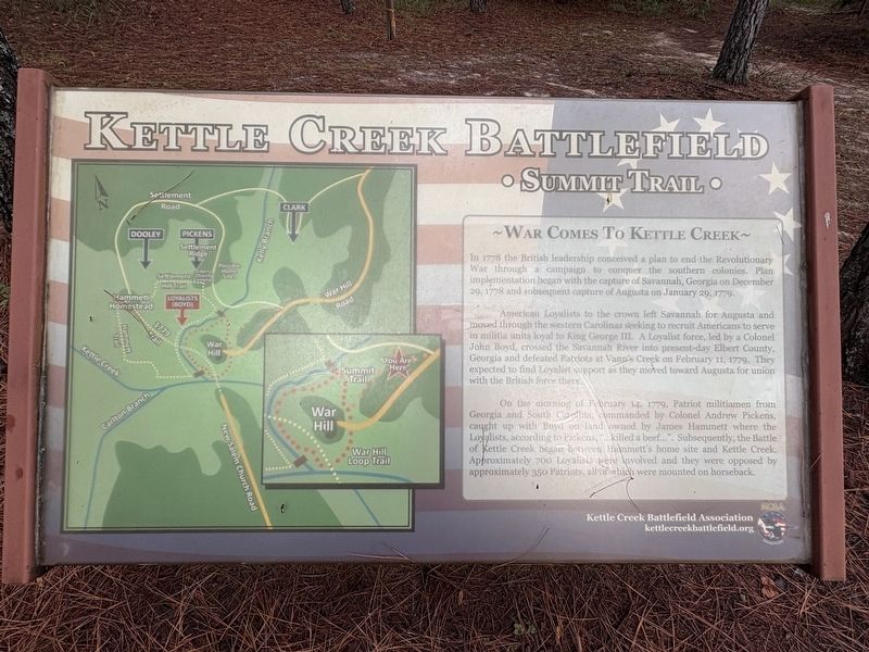
| — | Kettle Creek Battlefield • Summit Trail • | — |
Photographed by Darren Jefferson Clay, September 20, 2026
1. War Comes to Kettle Creek Marker
American Loyalists to the crown left Savannah for Augusta and moved through the western Carolinas seeking to recruit Americans to serve in militia units loyal to King George III. A Loyalist force, led by a Colonel John Boyd, crossed the Savannah River into present-day Elbert County, Georgia and defeated Patriots at Vann's Creek on February 11, 1779. They expected to find Loyalist support as they moved toward Augusta for union with the British force there.
On the morning of February 14, 1779, Patriot militiamen from Georgia and South Carolina commanded by Colonel Andrew Pickens, caught up with Boyd on land owned by James Hammett where the Loyalists, according to Pickens, "…killed a beef…". Subsequently, the Battle of Kettle Creek began between Hammett's home site and Kettle Creek. Approximately 700 Loyalists were involved and they were opposed by approximately
this page online
Erected by Kettle Creek Battlefield Association.
Topics. This historical marker is listed in this topic list: War, US Revolutionary. A significant historical date for this entry is February 14, 1779.
Location. 33° 41.553′ N, 82° 52.972′ W. Marker is in Washington, Georgia, in Wilkes County. It is at the intersection of War Hill Road and Settlement Road, on the right when traveling west on War Hill Road. Touch for map. Marker is at or near this postal address: 260 War Hill Rd, Washington GA 30673, United States of America. Touch for directions.

Regionally, this marker is in the Piedmont. It is also in the American South and specifically in the Deep South. Globally, it is in North America, the Western Hemisphere, the Western World, and the Anglosphere. Historically, it finds itself in what was once the territory of the Mississippian Culture, one of the original Thirteen Colonies, one of the Confederate States of America, and the Antebellum South.
Other nearby markers. At least 8 other markers are within 2 miles of this marker, measured as the crow flies: Clark's Attack (approx.
Photographed by Darren Jefferson Clay, September 20, 2026
2. War Comes to Kettle Creek Marker
Also see . . .
1. Kettle Creek Battlefield Association. (Submitted on October 11, 2026.)
2. Kettle Creek. American Battlefield Trust (Submitted on October 11, 2026.)
Credits. This page was last revised on October 11, 2026. It was originally submitted on September 20, 2026, by Darren Jefferson Clay of Duluth, Georgia. This page has been viewed 5 times since then. Photos: 1, 2. submitted on October 6, 2026, by Darren Jefferson Clay of Duluth, Georgia. • Bernard Fisher was the editor who published this page.
