Washington in Wilkes County, Georgia — The American South (South Atlantic)
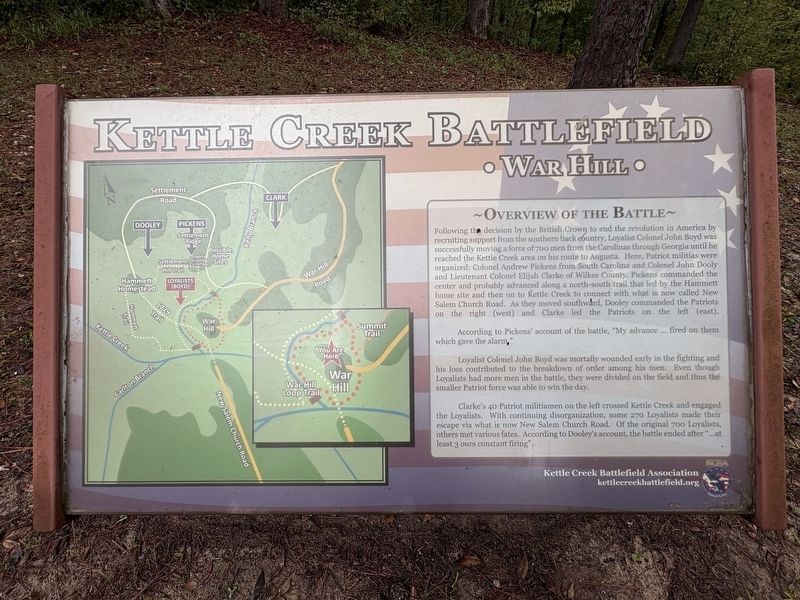
Overview of the Battle
| — | Kettle Creek Battlefield • War Hill • | — |
Photographed by Darren Jefferson Clay, September 20, 2026
1. Overview of the Battle Marker
According to Pickens' account of the battle, "My advance … fired on them which gave the alarm."
Loyalist Colonel John Boyd was mortally wounded early in the fighting and his loss contributed to the breakdown of order among his men. Even though Loyalists had more men in the battle, they were divided on the field and thus the smaller Patriot force was
this page online
Clarke's 40 Patriot militiamen on the left crossed Kettle Creek and engaged the Loyalists. With continuing disorganization, some 270 Loyalists made their escape via what is now New Salem Church Road. Of the original 700 Loyalists, others met various fates. According to Dooley's account, the battle ended after "…at least 3 ours constant firing".
Topics. This historical marker is listed in this topic list: War, US Revolutionary. A significant historical date for this entry is February 14, 1779.
Location. 33° 41.471′ N, 82° 53.169′ W. Marker is in Washington, Georgia, in Wilkes County. It is on War Hill Road 0.2 miles south of Settlement Road, on the right when traveling west. Touch for map. Marker is at or near this postal address: 299 War Hill Rd, Washington GA 30673, United States of America. Touch for directions.

Regionally, this marker is in the Piedmont. It is also in the American South and specifically in the Deep South. Globally, it is in North America, the Western Hemisphere, the Western World, and the Anglosphere. Historically, it finds itself in what was once the territory of the Mississippian Culture, one
Photographed by Darren Jefferson Clay, September 20, 2026
2. Overview of the Battle Marker
Other nearby markers. At least 8 other markers are within 2 miles of this marker, measured as the crow flies: Kettle Creek Battlefield (a few steps from this marker); The Battle of Kettle Creek (within shouting distance of this marker); a different marker also named Battle of Kettle Creek (within shouting distance of this marker); Revolutionary War Soldiers' Burials (within shouting distance of this marker); Early Colonial Roads (within shouting distance of this marker); Clark's Attack (about 300 feet away, measured in a direct line); War Comes to Kettle Creek (approx. 0.2 miles away); Phillips Mills Baptist Church (approx. 1.6 miles away). Touch for a list and map of all markers in Washington.
Credits. This page was last revised on October 11, 2026. It was originally submitted on September 20, 2026, by Darren Jefferson Clay of Duluth, Georgia. This page has been viewed 7 times since then. Photos: 1, 2. submitted on October 6, 2026, by Darren Jefferson Clay of Duluth, Georgia. • Bernard Fisher was the editor who published this page.
