Washington in Wilkes County, Georgia — The American South (South Atlantic)
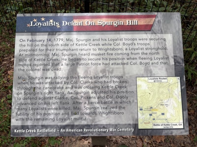
Loyalists Defeat On Spurgin Hill
| — | Kettle Creek Battlefield - An American Revolutionary Cemetery | — |
Photographed by Darren Jefferson Clay, September 19, 2026
1. Loyalists Defeat On Spurgin Hill Marker
Maj. Spurgin was rallying the fleeing Loyalist troops when he was attacked by Col. Clarke who had broken through the canebrake and was crossing Kettle Creek on Spurgin's right flank. As Spurgin adjusted his position to defend against Clarke, Col. Pickens and Col. Dooly advanced on his left flank. After a fierce battle in which many Loyalists were killed, Maj. Spurgin realized the futility of his position and fled towards Wrightsboro with the remaining Loyalist militia.
Topics. This historical marker is listed in this topic list: War, US Revolutionary. A significant historical date for this entry is February 14, 1779.
Location. 33° 41.385′ N, 82° 53.158′ W. Marker is in Washington, Georgia,
this page online

Regionally, this marker is in the Piedmont. It is also in the American South and specifically in the Deep South. Globally, it is in North America, the Western Hemisphere, the Western World, and the Anglosphere. Historically, it finds itself in what was once the territory of the Mississippian Culture, one of the original Thirteen Colonies, one of the Confederate States of America, and the Antebellum South.
Other nearby markers. At least 8 other markers are within walking distance of this marker: Canebrakes Affect The Battle of Kettle Creek (within shouting distance of this marker); 1920 Dredging of Kettle Creek (within shouting distance of this marker); Battle of Kettle Creek (about 400 feet away, measured in a direct line); Clark's Attack (about 400 feet away); "Cenotaph" (about 400 feet away); Kettle Creek Battlefield (about 500 feet away); a different marker
Photographed by Darren Jefferson Clay, September 19, 2026
2. Loyalists Defeat On Spurgin Hill Marker
Credits. This page was last revised on October 19, 2026. It was originally submitted on September 20, 2026, by Darren Jefferson Clay of Duluth, Georgia. This page has been viewed 8 times since then. Photos: 1, 2. submitted on October 6, 2026, by Darren Jefferson Clay of Duluth, Georgia. • Bernard Fisher was the editor who published this page.
