Liberty in Clay County, Missouri — The American Midwest (Upper Plains)
Monument to the Eight Witnesses
Photographed by Erika Brant, September 23, 2026
1. Monument to the Eight Witnesses Marker
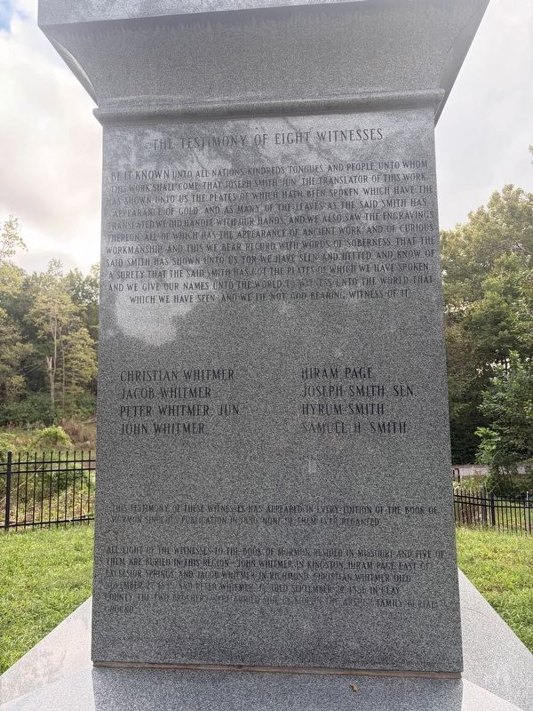
The Testimony of Eight Witnesses
The Testimony of Eight Witnesses
Be it known unto all nations, kindreds, tongues, and people, unto whom this work shall come that Joseph Smith Jun. the translator of this work has shown unto us the plates of which hath been spoken. Which have the appearance of gold, and as many of the leaves as the said Smith has translated we did handle with our hands and we also saw the engravings theron all of which as the appearance of ancient work and of curious workmanship and this we bear record with words of soberness that the said Smith has shown unto us for we have seen and hefted, and know of a surety that the said Smith has got the plates of which we have spoken and we give our names unto the world to witness unto the world that which we have seen and we lie not god bearing witness of it.
Christian Whitmer • Hiram Page • Jacob Whitmer • Joseph Smith, Sen. • Peter Whitmer, Jun. • Hyrum Smith • John Whitmer • Samuel H. Smith
This testimony of these witnesses has appeared in every edition of the Book of Mormon since its publication in 180. None of them ever recanted.
All eight of the witnesses to the Book
this page online
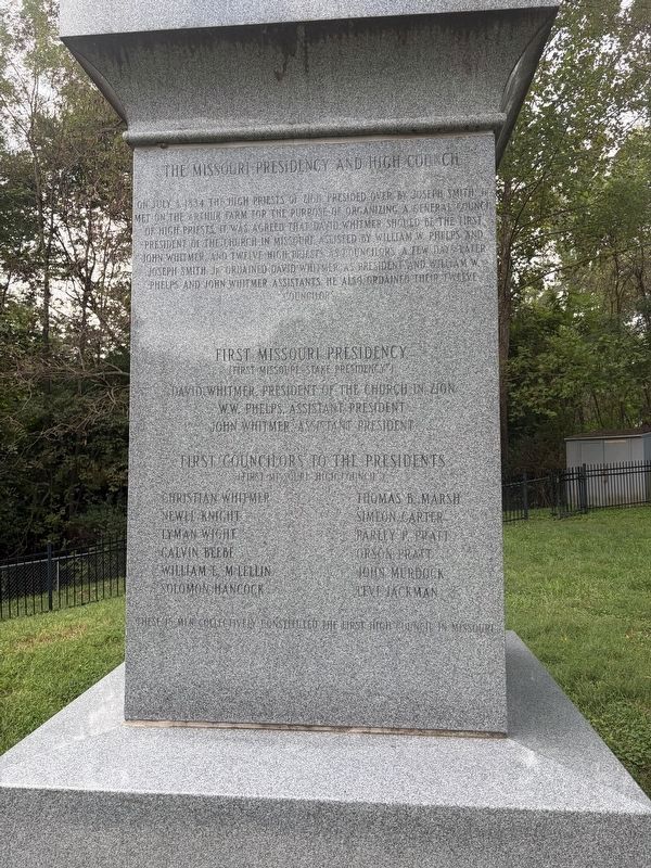
The Missouri Presidency and High Council
On July 3, 1834, the High Priests of Zion presided over by Joseph Smith, Jr. met on the Arthur farm for the purpose of organizing a general council of high priests. It was agreed that David Whitmer should be the first president of the church in Missouri, assisted by William W. Phelps and John Whitmer, and twelve high priests as councilors. A few days later, Joseph Smith, Jr. ordained David Whitmer as President and William W. Phelps and John Whitmer assistance. He also ordained their twelve councilors.
First Missouri Presidency
(First Missouri Stake Presidency)
David Whitmer, President of the Church in Zion • W.W. Phelps, Assistant President • John Whitmer, Assistant President
First councilors to the Preisidents
(First Missouri High Council)
Christian

Photographed by Erika Brant, September 23, 2026
2. Monument to the Eight Witnesses Marker
These 15 men collectively constituted the first High Council in Missouri.
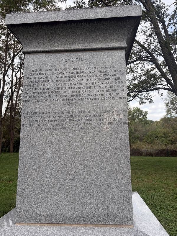
Zion's Camp
Beginning in May, 1834, Joseph Smith led a company of over 200 Mormon men, plus some women and children on an overland journey from Kirtland, Ohio, to western Missouri to assist the Mormons who had been expelled from Jackson County in late 1833 in reclaiming their property and homes. in late June 1834, shortly after Zion's Camp entered Clay County, Joseph Smith received divine council know as the Fishing River Revelation, directing him to appeal for peace. In the end, political, social, and circumstantial events prevented Zion's Camp from realizing its primary objective of assisting those who had bene displace to return to Jackson County.
While camped just a few mines north and east of this location, a cholera epidemic swept through Zion's Camp resulting in the deaths of thirteen camp members and two local Mormon residents. after the
Photographed by Erika Brant, September 23, 2026
3. Monument to the Eight Witnesses Marker
Zion's Camp
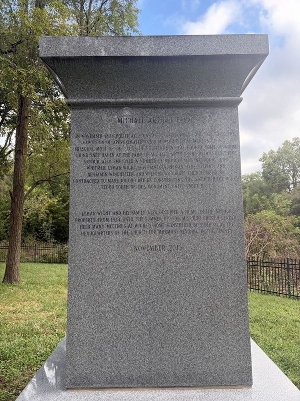
Michael Arthur Farm
In November 1833, political, economic and religious conflict led to the expulsion of approximately 1,200 Mormons from Jackson County, Missouri. Most of the exiles found refuge in Clay County, some of whom found safe haven at the farm of Michael Arthur who befriended them. Arthur also employed a number of Mormon men including John Whitmer, Lyman Wight, Levi Hancock, Heman Hyde, Stephan and Benjamin Winchester and Wilford Wood ruff. Church members contracted to make 100,000 bricks, constructing the Arthur home which stood south of this monument until about 1970.
Lyman Wight and his family also occupied a home on the Arthur property from 1834 until the summer of 1836. Missouri church leaders held many meetings at Wight's home considered by some to be the headquarters of the church form Mormons residing in the county.
November 2011
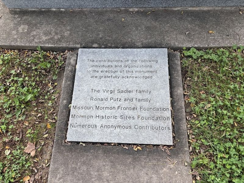
The contributions of the following individuals and organizations to the erection of this monument are gratefully acknowledged
The Virgil
Photographed by Erika Brant, September 23, 2026
4. Monument to the Eight Witnesses Marker
The Missouri Presidency and High Council
Erected 2011 by The Church of Jesus Christ of Latter-day Saints.
Topics. This historical marker is listed in these topic lists: Cemeteries & Burial Sites • Religion & Religious Structures. A significant historical month for this entry is July 1834.
Location. 39° 12.444′ N, 94° 26.992′ W. Marker is in Liberty, Missouri, in Clay County. It is on Campbell Drive south of South Liberty Parkway, on the right when traveling south. Touch for map. Marker is at or near this postal address: 2260 Campbell Dr, Liberty MO 64068, United States of America. Touch for directions.

Regionally, this marker is in the Missouri River Corridor and in Greater Kansas City. It is also in the American Midwest, in the Lewis & Clark Corridor, and in the Corn Belt. Globally, it is in North America, the Western Hemisphere, the Western World, and the Anglosphere. Historically, it finds itself in what was once the territory of the Mississippian Culture, the Louisiana Purchase, and the Antebellum South.
Photographed by Erika Brant, September 23, 2026
5. Monument to the Eight Witnesses Marker
Michael Arthur Farm
Other nearby markers. At least 8 other markers are within 3 miles of this marker, measured as the crow flies: Interurban Railway Bridge (approx. 1½ miles away); Interurban Railroad - Withers Station (approx. 1.9 miles away); Battle of Liberty / Blue Mills Landing (approx. 2.3 miles away); City Park (approx. 2.4 miles away); Ruth Ewing (approx. 2½ miles away); Liberty Arsenal (approx. 2½ miles away); Cemeteries, Burials and Fairview (approx. 2.8 miles away); Forging a Community (approx. 2.8 miles away). Touch for a list and map of all markers in Liberty.
Photographed by Erika Brant, September 23, 2026
6. Monument to the Eight Witnesses Marker
Credits. This page was last revised on September 24, 2026. It was originally submitted on September 23, 2026, by Erika Brant of Liberty, Missouri. This page has been viewed 12 times since then. Photos: 1, 2, 3, 4, 5, 6. submitted on September 23, 2026, by Erika Brant of Liberty, Missouri. • Devry Becker Jones was the editor who published this page.
