Koshkonong in Oregon County, Missouri — The American Midwest (Upper Plains)
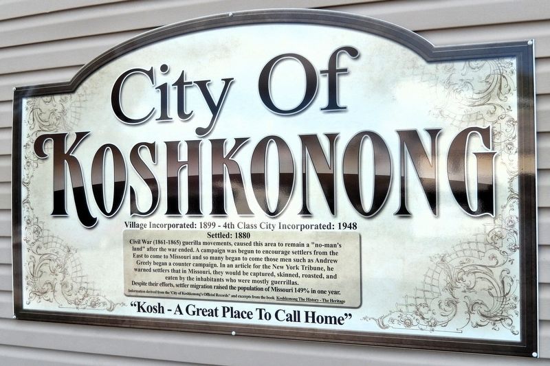
City of Koshkonong
Photographed by Cosmos Mariner, August 19, 2021
1. City of Koshkonong Marker
Settled: 1880
Despite their efforts, settler migration raised the population of Missouri 149% in one year.
Information derived from the “City of Koshkonong's Official Records” and excerpts from the book Koshkonong The History - The Heritage
Topics. This historical marker is listed in these topic lists: Settlements & Settlers • War, US Civil. A significant historical year for this entry is 1880.
Location. 36° 35.802′ N, 91° 38.728′ W. Marker is in Koshkonong, Missouri, in Oregon County. It is on Luyster Street just north of Diggins Street, on the left when traveling north. The marker is on
this page online

Regionally, this marker is in Southeast Missouri. It is also in the American Ozarks, in the Lewis & Clark Corridor, and in the Corn Belt. Globally, it is in North America, the Western Hemisphere, the Western World, and the Anglosphere. Historically, it finds itself in what was once the territory of the Mississippian Culture, the Louisiana Purchase, and the Antebellum South.
Other nearby markers. At least 8 other markers are within 10 miles of this marker, measured as the crow flies: Mittlestedter House (about 300 feet away, measured in a direct line); Jailhouse (about 400 feet away); Tedd Jasper Gullic (about 700 feet away); Koshkonong's Oak Ridge Cemetery History (approx. 0.6 miles away); Grand Gulf Sink (approx. 3.6 miles away); Grand Gulf (approx. 3.6 miles away); Community Auditorium (approx. 9 miles away in Arkansas); George D. Hay (approx. 9.2 miles away in Arkansas). Touch for a list and map of all markers
Photographed by Cosmos Mariner, August 19, 2021
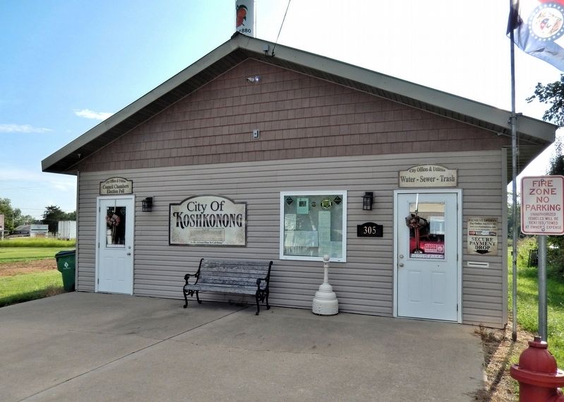
2. City of Koshkonong Offices
Looking southwest from Luyster Street. The marker is mounted near the center of the facade.
Also see . . .
1. History of Missouri (Wikipedia).
Excerpt: Western Missouri was the scene of brutal guerrilla warfare during the Civil War, and some marauding units became organized criminal gangs after the war. In such a bitterly divided state, neighbors frequently used the excuse of war to settle personal grudges and took up arms against neighbors. Roving insurgent bands such as Quantrill's Raiders and the supporters of Bloody Bill Anderson terrorized the countryside, striking both military installations and civilian settlements. In 1882, the bank robber and ex-Confederate guerrilla Jesse James was killed in Saint Joseph. Vigilante groups appeared in remote areas where law enforcement was weak, to deal with the lawlessness left over from the guerrilla warfare phase. The affected counties were economically devastated for years after the end of the war.(Submitted on September 24, 2026, by Cosmos Mariner of Cape Canaveral, Florida.)
2. Koshkonong Community (Oregon County MO Historical Society).
Excerpt: Koshkonong is an Indian name meaning “wild rice.” Because of natural ponds in the vicinity, R.R. Hammond was district supervisor for the Kansas City, Fort Scott, and Memphis Railroads then laying track in this area named the community Koshkonong, after Lake Koshkonong in southern Wisconsin, a habitat for wild ducks and geese.(Submitted on September 24, 2026, by Cosmos Mariner of Cape Canaveral, Florida.)
In 1880, Hardy Shurrton homesteaded on land now part of the Wesson Charlais Ranch. in 1882, for $10, a ham and a side of bacon, Shurron traded his land to Sereno Standley, an employee in the construction of the railroad, later known as the Frisco Railroad. In the same year, Sereno Standley and his wife Martha built a double log house, which was not only their home but also a boarding house, store and post office.
Credits. This page was last revised on September 24, 2026. It was originally submitted on September 23, 2026, by Cosmos Mariner of Cape Canaveral, Florida. This page has been viewed 9 times since then. Photos: 1, 2. submitted on September 24, 2026, by Cosmos Mariner of Cape Canaveral, Florida.
