Clarksburg in Montgomery County, Maryland — The American Northeast (Mid-Atlantic)
Our Daily Bread
The Hyattstown Mill
Photographed by Allen C. Browne, April 16, 2016
1. Our Daily Bread Marker
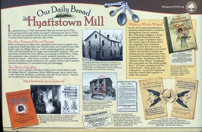
In operation since 1798, Hyattstown Mill was known for its “fine stone-ground white and yellow cornmeal." Destroyed by fire in 1918, the new mill was quickly rebuilt on the old foundation and remained a crucial local business until the mid-1930s.
The New Patented Marvel Process
While continuing to utilize water propelled stone buhrs to grind Corn, proprietors Frank. Mortimer and Charles Luhn also outfitted their new facility with the Midget Marvel, a self-contained gasoline operated roller mill distributed by the Anglo-American Mill Company. This new machinery allowed for more efficient processing of wheat flour. Using this equipment also resulted in a more sanitary operation, as “no hands but yours” — that of the consumer — touched the final product. Due to the public health movement, the quality of flour had to achieve “perfect cleanliness” in manufacturing and packaging.
The Mark of Quality
By 1922, over a quarter of all flour mills in the United States used the Midget Marvel. Hyattsown Roller Mills became one of more than 1,300 American facilities to advertise and sell “FLavo FLour.” Known for its
this page online
“often buttered, never bettered”
White of Whole Wheat?
In the 1913 national publication, Economy Administration Cookbook, Montgomery County resident Mrs. Townsend supplied a recipe for Steamed Brown Bread that utilized 5 cups of “graham” flour. The coarse-textured whole-wheat she suggested was healthier option to white flour, because,it aided in better digestion and'overall vitality. Nutritionists believed the milling milling process stripped white flour of essential vitamins necessary for a balanced diet. Hyattstown Mill sold “graham whole-wheat,“ identifying this commodity as “the health giving flour” All three components of the wheat kernel -- bran, germ, and endosperm are ground separately, and then mixed back together to make this product.
Erected by Montgomery Parks.
Topics and series. This historical marker is listed in these topic lists: Food & Drink • Industry & Commerce • Man-Made Features. In addition, it is included in the Maryland, Montgomery Parks series list. A significant historical year for this entry is 1798.
Location. 39° 16.784′ N, 77° 18.707′ W. Marker is in Clarksburg, Maryland, in Montgomery County. It can be reached from Hyattstown Mill Road 0.2 miles east of Frederick Road (Maryland Route 355), on the right when traveling east. Touch for map. Marker is at or near this postal address: 14290 Hyattstown Mill Road, Clarksburg MD 20871, United States of America. Touch for directions.

Regionally, this marker is in the Washington Metropolitan Area. It is also in the American Mid-Atlantic. Globally, it is in North America, the Western Hemisphere, the Western World, and the Anglosphere. Historically, it finds itself in what was once one of the original Thirteen Colonies and also the Antebellum South.
Other nearby markers. At least 8 other markers are within 3 miles of this marker, measured as the crow flies: Hyattstown Mill (a few steps from this marker); Women on the Homefront in Montgomery County (approx. 0.6 miles away); A Real Field of Dreams (approx. one mile away); Welcome to Froggy Hollow (approx. 2.1 miles away); a different marker also named George Washington (approx. 2.9 miles away); Mount Ephraim Crossroads (approx. 3 miles away); 1862 Antietam Campaign (approx. 3 miles away); Comus Inn (approx. 3 miles away). Touch for a list and map of all markers in Clarksburg.
Other markers no longer nearby. Hyattstown (was about 800 feet away, measured in a direct line but has been confirmed missing); George Washington (was approx. 2.9 miles away but has been confirmed missing); Mt. Ephraim Crossroads (was approx. 3 miles away but has been reported to have been replaced with another marker now near it).
Credits. This page was last revised on September 25, 2026. It was originally submitted on July 13, 2016, by Allen C. Browne of Silver Spring, Maryland. This page has been viewed 937 times since then and 56 times this year. Last updated on September 25, 2026, by Trudi Jacobson of Slingerlands, New York. Photo 1. submitted on July 13, 2016, by Allen C. Browne of Silver Spring, Maryland. • Devry Becker Jones was the editor who published this page.
Editor’s want-list for this marker. Wide shot of the marker in context. • Can you help?
