St Katharine's & Wapping in Tower Hamlets in Greater London, England, United Kingdom — Northwestern Europe (the British Isles)
Controlling the River
Discover the Fortress story
Photographed by Ian Lefkowitz, September 11, 2026
1. Controlling the River Marker

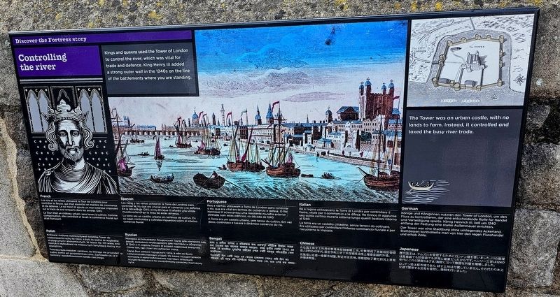
Kings and queens used the Tower of London to control the river, which was vital for trade and defence. King Henry III added a strong outer wall in the 1240s on the line of the battlements where you are standing.
The Tower was an urban castle, with no lands to farm. Instead, it controlled and taxed the busy river trade.
Les rois et les reines utilisaient la Tour de Londres pour contrôler le fleuve, qui était essentiel en matière de commerce et de défense. Le roi Henri III fit ériger une solide muraille extérieure sur le tracé de ces créneaux dans les années 1240. La Tour était un château urbain, sans terres à cultiver. Comme compensation, elle contrôlait et taxait le commerce fluvial qui était florissant.
Los reyes y las reinas utilizaban la Torre de Londres para controlar el río, que era vital en términos de comercio y de defensa. En la década de 1240, el rey Enrique III añadió una sólida muralla exterior en la línea de estas almenas. La torre era un castillo urbano sin tierras de cultivo. En su lugar, controlaba y cobraba impuestos sobre el intenso comercio fluvial.
Reis
this page online
Re e regine utilizzavano la Torre di Londra per controllare il fiume, vitale per il commercio e la difesa. Re Enrico III aggiunse una solida cortina muraria esterna lungo questi bastioni intorno al 1240. La torre era un castello cittadino, senza terreni da coltivare. Era utilizzata per controllare l’intenso commercio fluviale e per riscuoterne le imposte.
Könige und Königinnen nutzten den Tower of London, um den Fluss zu kontrollieren, der eine entscheidende Rolle für Handel und Verteidigung spielte. König Heinrich III. ließ um 1240 entlang der Festung eine starke Außenmauer errichten. Der Tower war eine Stadtburg ohne umliegendes Ackerland. Stattdessen kontrollierte man von hier den regen Flusshandel und erhob Zölle.
Królowie i królowe wykorzystywali twierdzę Tower do nadzorowania rzeki,
Photographed by Ian Lefkowitz, September 11, 2026
2. Controlling the River Marker
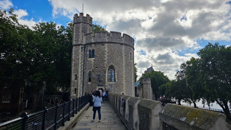
The marker is located on the walkway to Lanthorn Tower.
Монархи использовали Лондонский Тауэр для контроли над рекой, жизненно необходимой для торговли и обороны. В 1240-х гг. король Генрих III возвёл надёжную внешнюю стену там, где стоят нынешние бойницы. Тауэр был замком городского типа, в нём не было сельскохозяйственных угодий. Из замка осуществлялись контроль и налогообложение торговых операций, осуществлявшихся по оживлённому речному торговому пути.
রাজা ও রানীরা বালিতা ও প্রতিরক্ষা জন্য প্রশাসনিক নদীকণ্ঠে নিয়ন্ত্রণ করার জন্য চাইতেন এবং সেই সাথে সড়কযুক্ত ব্যবসায় বাণিজ্য করতেন। ভূমিটি দুর্গের পাশে 1240 সালে রাজা তৃতীয় হেনরি প্রাচীর বরাবর শক্তিশালী বাইরের দেয়াল বানিয়েছিলেন। লন্ডনটাওয়ার ছিল শহর দুর্গ, চাষাবাদের জমি সংলগ্ন ছিল না—টাওয়ারটি নদীপথ নিয়ন্ত্রণ করে এবং ডাক উপর করা ব্যালাত।
众位国王和女王利用伦敦塔来控制泰晤士河,伦塔成了贸易和御敌的通道。13世纪40年代,国王亨利三世下令在城垛上建造坚固的外墙。伦敦塔以往是一座市城堡,附近并无农地。塔楼控制了繁忙的河上贸易场。
歴代国王は、テムズ川を管するためにロンドン塔を使いました。川の管理は国防と繁栄する交易にとっても重要でした。ヘンリー三世は1240年代にこまち狭間(はざま)胸壁に沿って強固な外壁を増築しました。ロンドン塔は都市城であり、耕す土地は付属していません。交通で繁栄する交易を管理し、徴税を行いました。その代わりに水上
Erected by Historic Royal Palaces.
Topics. This historical marker is listed in these topic lists: Forts and Castles • Waterways & Vessels. A significant historical year for this entry is 1240.
Location. 51° 30.447′ N, 0° 4.563′ W. Marker is in Tower Hamlets, England, in Greater London. It is in St Katharine's & Wapping. It can be reached from the intersection of Tower Bridge Approach and Tower Hill, on the left when traveling north. Touch for map. Marker is in this post office area: Tower Hamlets, England EC3N 4DT, United Kingdom. Touch for directions.

Regionally, this marker is in London and in the Greater South East. Globally, it is on the Atlantic Ocean, in the North Atlantic Region, in Europe, in Atlantic Europe, on one of the British Isles, in the Western World, and in the Anglosphere. Historically, it finds itself in what was once the Roman Empire.
Other nearby markers. At least 8 other markers are within walking distance of this marker: Iron 12 pounder Gun (here, next to this marker); a different marker also named Iron 12 pounder Gun (here, next to this marker); Iron 32 pounder Gun (here, next to this marker); Iron 9-pounder Cannon (here, next to this marker); Iron 24-pounder Howitzer and Carriage (here, next to this marker); a different marker also named Iron 32 pounder Gun (a few steps from this marker); Iron 36 pounder Guns (a few steps from this marker); Iron 24 pounder Guns (a few steps from this marker). Touch for a list and map of all markers in Tower Hamlets.
Another marker is no longer nearby. A Royal River View (was here, next to this marker but has been replaced with another marker now near it).
Credits. This page was last revised on September 28, 2026. It was originally submitted on September 27, 2026, by Ian Lefkowitz of New York, New York. This page has been viewed 5 times since then. Photos: 1, 2. submitted on September 27, 2026, by Ian Lefkowitz of New York, New York. • Andrew Ruppenstein was the editor who published this page.
