Prescott Farm in Middletown in Newport County, Rhode Island — The American Northeast (New England)
Wind at Work
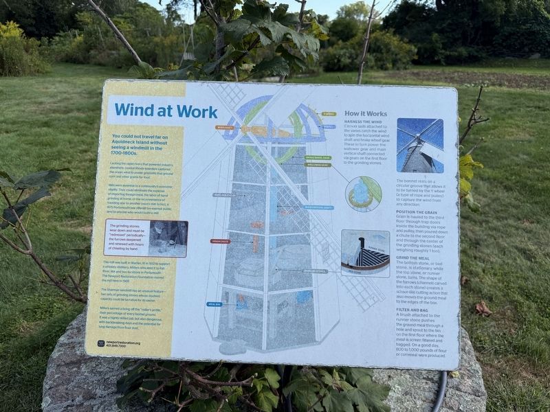
You could not travel far on Aquidneck Island without seeing a windmill in the 1700-1800s.
Lacking the rapid rivers that powered industry elsewhere, coastal Rhode Islanders captured the ocean wind to power gristmills that ground corn and other grains for food.
Mills were essential to a community's economic vitality. They could eliminate the expense of importing foreign meal, the labor of hand grinding at home, or the inconvenience of traveling after to another town's mill. In fact, a 1675 Portsmouth law offered tax-exempt public land to anyone who would build a mill.
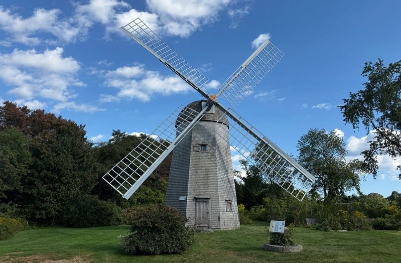
This mill was built in Warren, RI in 1812 to support a whiskey distillery. Millers relocated it to Fall River, MA and two locations in Portsmouth. The Newport Restoration Foundation moved the mill here in 1969.
The Sherman windmill has an unusual feature—two sets of grinding stones whose doubled capacity could be lucrative for its owner.
Millers earned a living off the "miller's pottle," their percentage of every bushel ground. It was a highly skilled job, but also dangerous, with backbreaking days and the potential for lung damage from flour
this page online
How It Works
Harness the Wind
Canvas sail attached to the vanes catch the wind to spin the horizontal wind shaft and brake wheel gear. These in turn power the wallower gear and main vertical shaft connected via gears on the first floor to the grinding stones.
The bonnet rests on a circular groove that allows it to be turned by the Y wheel (a type of rope and pulley) to capture the wind from any direction.
Position the Grain
Grain is hauled to the third floor through trap doors inside the building via rope and pulley, then poured down a chute to the second floor and through the center of the grinding stones (each weighing roughly 1 ton).
Grind the Meal
The bottom stone, or bed stone, is stationary while the top stone, or runner stone, turns. The shape of the furrows (channels carved into each stone) creates a scissor-like cutting action that also moved the ground meal to the edges of the box.
Filter and Bag
A brush attached to the runner stone pushes the ground meal through a hole and spout to the bin on the first floor where the meal is screen filtered and bagged. On a good day, 800 to 1,000 pounds of flour
[Caption:]
The grinding stones wear down and must be "redressed" periodically—the furrows deepened and renewed with hours of chiseling by hand.
Erected by Newport Restoration Foundation.
Topics. This historical marker is listed in these topic lists: Agriculture • Industry & Commerce. A significant historical year for this entry is 1675.
Location. 41° 33.168′ N, 71° 17.402′ W. Marker is in Middletown, Rhode Island, in Newport County. It is in Prescott Farm. It is on West Main Road (Rhode Island Route 114) south of Freedom Trail Drive, on the left when traveling south. Touch for map. Marker is at or near this postal address: 2009 W Main Rd, Middletown RI 02842, United States of America. Touch for directions.

Regionally, this marker is on Narragansett Bay and in Newport and Aquidneck Island. It is also in the American Northeast, in New England, and on the Eastern Seaboard. Globally, it is in the North Atlantic Region, North America, the Western Hemisphere, the Western World, and the Anglosphere. Historically, it finds itself in what was once one of the original Thirteen Colonies.
Other nearby markers. At least 8 other markers are within 4 miles of this marker, measured as the crow flies: Prescott’s Headquarters (within shouting distance of this marker); Summer Headquarters (within shouting distance of this marker); Welcome to Prescott Farm (about 300 feet away, measured in a direct line); World War I Memorial Tower (approx. 3.1 miles away); Green End Fort (approx. 3.4 miles away); The Black Regiment (approx. 3.7 miles away); The 1st Rhode Island Regiment and the Battle of Rhode Island (approx. 3.7 miles away); Site of the Battle of Rhode Island (approx. 3.7 miles away). Touch for a list and map of all markers in Middletown.
Credits. This page was last revised on September 30, 2026. It was originally submitted on September 27, 2026, by Devry Becker Jones of Washington, District of Columbia. This page has been viewed 8 times since then. Photos: 1, 2. submitted on September 27, 2026, by Devry Becker Jones of Washington, District of Columbia.
