Delphi in Carroll County, Indiana — The American Midwest (Great Lakes)
Wabash & Erie Canal
Commerce & Culture
| — | Wabash and Erie Canal Delphi, Indiana Celebrating the Past Building for the Future | — |
Photographed by Craig Doda, September 13, 2026
1. Wabash & Erie Canal Marker
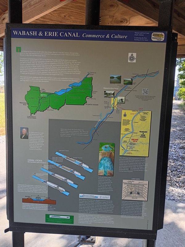
The Wabash & Erie Canal ran 468 miles from Toledo, Ohio to Evansville, Indiana, thus providing access to New York and the East Coast via the Erie Canal and access to New Orleans and the Gulf of Mexico via the Ohio and Mississippi Rivers.
Construction in Indiana began in 1832 in Fort Wayne. Passenger and freight boats were regularly operated, and manufactured goods to Delphi and Carroll County by 1840 and by 1843 the Canal was open to Terre Haute. By 1853 the Canal was completed to Evansville, Indiana. Thus, the Canal became a cultural conduit, bringing access to the latest fashions and products from the urban centers in the East to Delphi and the wilderness of the Midwest. At the same time the Canal opened markets for the lime and paper businesses which flourished along the Canal era. Being the longest man-made structure in the United States, the Wabash & Erie Canal was a feat of engineering that required a combination of locks, aqueducts, dams and feeder streams. In Indiana the Canal reached 73 locks and 18 aqueducts to allow a boat to travel to the next level as they transported their passengers and cargo from town
this page online
The Canal traversed a landscape that was not at all level. Locks were constructed at strategic locations along the Canal in order to raise or lower boats to the next level as they transported their passengers and cargo from town to town to their destinations.
[Captions:]
In 1838 community leader Wabash E. Reed, of Reed Case, received the first contract for building the Canal between Logansport and Lafayette, with Delphi located roughly halfway between each city. In 1844 he built the grand federal style "Reed Case House" located in Canal Park.
Constructed of wood or stone, a typical lock was 15 feet wide and 90-100 feet long. Each lock was custom built to lift or lower boats a specified number of feet. In Indiana some locks were built to lift a boat 6 feet while others were built to lift a boat as much as 10 feet.
The cross-section of the Canal gives us a better understanding of how the Canal must be narrow and shallow in order to pass other boats. The towpath was used by mules or "muley" who walked behind the horses while loading and unloading passengers and cargo. Notice how closely the Canal follows the Wabash River and its tributaries. This allows the Canal to follow a relatively level valley and also provides a source of water to maintain a constant depth in the Canal.
Lock gate doors in the foreground are being closed and wicket gates are opened in preparation for a boat entering the lock. 32. The rear gate doors are closed and the wicket gates will be opened so a boat can enter the lock chamber before being lowered to the Wabash River level.
Boats used on the Canal were designed and built specifically for Canal travel. These included barges, meatboats, sailboats, and others while passenger boats were most appropriate for Canal travel. A Canal boat was narrow and shallow to fit the shallow draft. At 8 feet deep and 15 feet wide the Canal allowed boats to pass. Each lock was only 15 feet wide and 90-100 feet long. Each boat was usually 10 feet wide or a barge carrying produce, most Canal boats were 80 feet long.
Using long ropes the boats were pulled by mules or horses followed by a driver, or "hoagy", who walked behind the horses along an established towpath. Many boats had a cabin which extended almost the entire length of the boat in order to provide a maximum amount of space for passengers or cargo inside as well as flat space on the roof.
This 1874 map shows the position of the Canal as it passed through Delphi in its heyday. Notice the locks and dams which were a key component of the success of the Canal. The Canal was the central location for freight boats to unload and pick up goods. In the Delphi Case, Spears Warehouse at the head of the lock (where McDonald's Arbys is now located) became a main clearing house for goods.
Lock gates constructed of heavy timbers and placed at each end of a lock were used to lift and lower boats as they traveled the Canal. Each gate contained a wicket gate, which was a small paddle gate or sluice valve, which was used to fill the lock chamber with water into and out of the lock chamber. When the wicket gates were opened, each wicket gate could be opened and closed by turning the lock keys at the top. A mitre sill held the gates in the upstream position when they were closed.
Erected by Carroll
Photographed by Craig Doda, September 13, 2026
2. Wabash & Erie Canal Marker
Topics and series. This historical marker is listed in these topic lists: Industry & Commerce • Waterways & Vessels. In addition, it is included in the Wabash & Erie Canal series list. A significant historical year for this entry is 1832.
Location. 40° 35.668′ N, 86° 39.379′ W. Marker is in Delphi, Indiana, in Carroll County. It is at the intersection of Old Camden Road and East Main Street, on the right when traveling north on Old Camden Road. Touch for map. Marker is at or near this postal address: 1600 Old Camden Rd, Delphi IN 46923, United States of America. Touch for directions.

Regionally, this marker is in Northern Indiana. It is also in the American Midwest and in the Corn Belt. Globally, it is in North America, the Western Hemisphere, the Western World, and the Anglosphere. Historically, it finds itself in what was once the territory of the Mississippian Culture and also the Northwest Territory.
Other nearby markers. At least 8 other markers are within walking distance of this marker: Welcome to Delphi (here, next to this marker); Monon High Bridge Trail (within shouting distance of this marker); Retaining the Past & Forging the Future (about 300 feet away, measured in a direct line); Site of Cabin Home Gen. Samuel Milroy (about 400 feet away); Entombed Aboard the USS Arizona (about 600 feet away); a different marker also named Wabash & Erie Canal (about 700 feet away); Deer Creek Valley Rural Historic District (approx. half a mile away); Foreman-Case House (approx. 0.9 miles away). Touch for a list and map of all markers in Delphi.
Another marker is no longer nearby. Samuel Milroy (was about 400 feet away but has been confirmed missing).
Credits. This page was last revised on October 8, 2026. It was originally submitted on October 2, 2026, by Craig Doda of Napoleon, Ohio. This page has been viewed 9 times since then. Photos: 1, 2. submitted on October 2, 2026, by Craig Doda of Napoleon, Ohio. • Devry Becker Jones was the editor who published this page.
