Keystone in Pennington County, South Dakota — The American Midwest (Upper Plains)
Holy Terror Mine
Photographed by William Fischer, Jr., September 21, 2026
1. Holy Terror Mine Marker
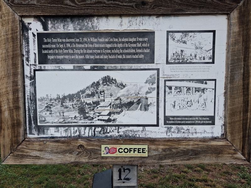
The Holy Terror Mine was discovered June 28, 1894, by William Franklin and Cora Stone, his adopted daughter. It was a very successful mine. On Sept. 6, 1896, a fire threatened the lives of three miners trapped in the depths of the Keystone Shaft, which is located north of the Holy Terror Mine. During the fire almost everyone in Keystone, including the schoolchildren, formed a bucket brigade to transport water to save the miners. After many hours and many buckets of water, the miners reached safety[.]
[Right side photo captions, top and bottom, read]
• A few days after the Holy Terror claim was located in June, miners throughout the Black Hills attended a flag waving celebration on the Fourth of July. They had the privilege of picking up specimens from the ledge or vein.
• Miners at the entrance to the mine as seen in the 1890s. Truly a boom town, the population of Keystone quickly increased to over 2,000 after gold was discovered.
Erected 2005 by Keystone Area Historical Society. (Marker Number 12.)
Topics. This historical marker is listed in these topic lists: Environment • Industry & Commerce •
this page online
Location. 43° 53.817′ N, 103° 25.145′ W. Marker is in Keystone, South Dakota, in Pennington County. It is on 1st Street (State Highway 40) north of Mitchell Street, on the left when traveling north. Touch for map. Marker is at or near this postal address: 515 1st Street, Keystone SD 57751, United States of America. Touch for directions.

Regionally, this marker is in West River, in the Badlands, and in Greater Rapid City. It is also in the American Black Hills, in the Lewis & Clark Corridor, on the prairies, and on the Northern Plains. Globally, it is in North America, the Western Hemisphere, the Western World, and the Anglosphere. Historically, it finds itself in what was once Rupert’s Land and also the Louisiana Purchase.
Other nearby markers. At least 8 other markers are within walking distance of this marker: Site of Ernest "Peg Leg" Haase Blacksmith Shop (within shouting distance of this marker); Keystone Trading Company/Halley's Store (within shouting distance of this marker); Halley's Store Icehouse (within shouting distance of this marker);
Photographed by William Fischer, Jr., September 21, 2026
2. Holy Terror Mine Marker
Also see . . .
1. Historic Keystone Walking Tour. (Submitted on October 3, 2026, by William Fischer, Jr. of Reynoldsburg, Ohio.)
2. Keystone SD History. Includes mention of the Holy Terror Mine (Submitted on October 3, 2026, by William Fischer, Jr. of Reynoldsburg, Ohio.)
Credits. This page was last revised on October 3, 2026. It was originally submitted on October 3, 2026, by William Fischer, Jr. of Reynoldsburg, Ohio. This page has been viewed 9 times since then. Photos: 1, 2. submitted on October 3, 2026, by William Fischer, Jr. of Reynoldsburg, Ohio.
