Richmond in Washington County, Rhode Island — The American Northeast (New England)
A Maturing Town
| — | Richmond Heritage Trail | — |
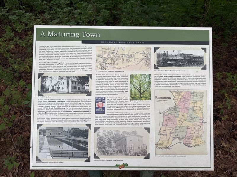
During the late 1800s, agriculture remained a livelihood in Richmond. The nearby Reynolds Hoxsie Farm was most impressive. An abundance of crops included large fields of potatoes, and corn which produced the largest and heaviest ears in the area. The corn fed a herd of twelve cows whose milk was sold to South County Creamery. A beautiful orchard included trees laden with pears, peaches, apples, quince, plums and cherries. Grapes, strawberries, barberries, gooseberries, currants and tomatoes were also grown here. A cranberry bog was also in use, the entire property impressively set out and maintained, its livestock including hogs and a large flock of hens.
About 1871, Wanton Lillibridge built a house on the family plantation property, very near the entrance to this park. Large and elaborate, the house contained many rooms and the third-floor attic was built with cedar. The Perry Plantation, once located just southwest of here, and later, known as the Halsey P. Clarke homestead, contained a blacksmith shop with slave quarters on the upper level. Many additions were made to the house over the years.
In 1877, John W.
this page online
In Wyoming village, William Francis Segar opened a mercantile store across from the tavern in 1850. Business boomed and became a principal trading locale in the region. Additions to the flourishing store were made in 1853 and 1896.
By this time, less natural forest remained in Richmond, having been cleared away. Farms that remained played an integral part in the sustenance of residents. However,
In Usquepaugh Village, 4 miles east of here, Charles Kenyon established the Kenyon Corn Meal Company on the Queens River near the Richmond town line in 1909. Farmers throughout the region came to the mill to have their corn ground into meal, often used to make johnny cakes. A series of prior mills and dams were built here, the earliest in 1708, and owned by Rowland Robinson.
Local farms and homes planted or preserved large shade trees, and maintained small orchards of apple, pear, peach, and cherry trees. American chestnut, an important tree species for home construction, furniture, and other wood uses, persisted as large shade trees in Richmond during the early 1900s. Nuts from these trees were prized as food, often heated before eaten. Sadly, the chestnut blight, a pathogenic fungus, wiped out the great chestnut trees throughout the Eastern U.S. Another ecological tragedy, the passenger pigeon, once one of the most common birds in the U.S., was over hunted and extirpated by 1914.
During this period, trains provided local transportation and commerce, such as the Wood River Branch Railroad. Later called the Tooneyville Trolley, this railway began in 1873 and operated for 74 years, carrying people and commerce between Hope Valley and Wood River Junction. Eventually, as highways and roads were laid out, land was more valuable in terms of potential development than in maintaining the agricultural pursuits that had created a simple livelihood for residents for so long. Electricity came to Richmond in 1913, and increased land use changes.
Erected by Town of Richmond, Rhode Island.
Topics. This historical marker is listed in these topic lists: Agriculture • Horticulture & Forestry • Industry & Commerce • Railroads & Streetcars. A significant historical year for this entry is 1871.
Location. 41° 30.289′ N, 71° 40.004′ W. Marker is in Richmond, Rhode Island, in Washington County. It is on Richmond Heritage Trail north of Country Acres Road, on the right when traveling south. Touch for map. Marker is at or near this postal address: 116 Kingstown Rd, Wyoming RI 02898, United States of America. Touch for directions.

Regionally, this marker is on Narragansett Bay and in South County. It is also in the American Northeast, in New England, and on the Eastern Seaboard. Globally, it is in the North Atlantic Region, North America, the Western Hemisphere, the Western World, and the Anglosphere. Historically, it finds itself in what was once one of the original Thirteen Colonies.
Other nearby markers. At least 8 other markers are within 3 miles of this marker, measured as the crow flies: Early Town of Richmond (about 300 feet away, measured in a direct line); Recent Times and the Future of Richmond (about 300 feet away); Early European Settlement (about 400 feet away); Post-Glaciation and Native Peoples (about 500 feet away); Richmond: A Town with Vision of Its Heritage and History (about 600 feet away); World War I, World War II and the Korean Campaign Memorial (approx. half a mile away); Vietnam and Desert Storm Memorial (approx. half a mile away); Depot Square Park (approx. 2.6 miles away). Touch for a list and map of all markers in Richmond.
Credits. This page was last revised on October 4, 2026. It was originally submitted on October 3, 2026, by Devry Becker Jones of Washington, District of Columbia. This page has been viewed 5 times since then. Photos: 1. submitted on October 3, 2026, by Devry Becker Jones of Washington, District of Columbia. 2. submitted on October 4, 2026, by Devry Becker Jones of Washington, District of Columbia.
