Historic District in St. Augustine in St. Johns County, Florida — The American South (South Atlantic)
Tolomato Cemetery
Photographed by Stephen Thomas White, May 3, 2026
1. Tolomato Cemetery Marker
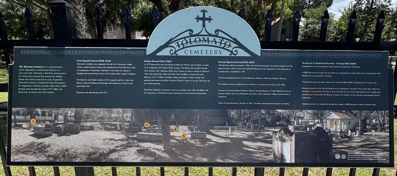
The Tolomato Cemetery is a representation of St. Augustine's multicultural history in a one-acre site. Tolomato is the final resting place for those from around the world who helped shape the history and future of St. Augustine. Tolomato's history is presented here throughout. St. Augustine's historic periods. More than 1,000 people were buried here from 1777-1884, yet there are currently only 105 markers.
First Spanish Period (1565-1763)
Tolomato Cemetery was originally the site of a Franciscan Indian mission called Nuestra Señora de Guadalupe de Tolomato (Our Lady of Guadalupe of Tolomato). Tolomato is the name of a place in Georgia that was the first home of the Guale Indian mission residents.
The Spanish and Indian citizens of St. Augustine left for Cuba and Mexico when the British arrived upon the settlement of the French and Indian War.
Tolomato was abandoned until 1777.
British Period (1763-1783) In 1777, Minorcans from the Island of Minorca off the coast of Spain arrived in St. Augustine with Father Pedro Camps. The Minorcans included people from Greece, Italy, Sardinia, Sicily and Corsica,
this page online
Tolomato Cemetery remained in use as a cemetery even after the British left St. Augustine in 1783 following the settlement of the American Revolution.
Second Spanish Period (1784-1821)
The Spanish citizens returned in 1784, and Tolomato became the parish cemetery for the parish church, which is now the Cathedral Basilica of St. Augustine on the Plaza de la Constitución, completed in 1797.
The first recorded burial is of Gertrudis Pons Paceti in 1784 from Mahon, Minorca.
The oldest existing marked burial in Florida is of Elizabeth Forrester (1) in 1798.
During the Second Spanish Period, General George Biassou of Haiti, Spanish Governor Enrique White, Don Juan McQueen and many other important citizens were buried at Tolomato.
When Florida became a Territory in 1821, Tolomato remained as the parish cemetery.
Territorial & Statehood Periods - Closing (1821-1884)
Photographed by Stephen Thomas White, May 3, 2026
2. Tolomato Cemetery Marker
Descendants of many important early families are buried at Tolomato.
In 1853, the Varela Chapel (2) was built as a mausoleum for the Cuban-born priest Father Felix Varela. He is now buried in Havana.
There are burials from both sides of the Civil War (1861-1865), including two Freedmen (3).
Bishop Augustin Verot (4), first Bishop of St. Augustine, is buried in the center aisle. Near him are Sister Louis Joseph and Sister Julie Clotilde (5), two of the eight Sisters of St. Joseph who arrived from France with the Bishop to teach the children of the recently emancipated African Americans.
Tolomato and all St. Augustine cemeteries closed in 1884 because of fears of yellow fever.
Topics. This historical marker is listed in this topic list: Cemeteries & Burial Sites. A significant historical year for this entry is 1777.
Location. 29° 53.838′ N, 81° 18.913′ W. Marker is in St. Augustine, Florida, in St. Johns County. It is in the Historic District. It is on Cordova Street 0.1 miles south of Orange Street, on the left when traveling north. Touch for map. Marker is at or near this postal address: 6 Cordova Street, Saint Augustine FL 32084, United States of America. Touch for directions.

Regionally, this marker is in First Coast and in Greater Jacksonville. It is also in the American South and on the Eastern Seaboard. Globally, it is in the North Atlantic Region, North America, a Gulf of Mexico state, the Western Hemisphere, the Western World, and the Anglosphere. Historically, it finds itself in what was once New Spain, the territory of the Mississippian Culture, one of the Confederate States of America, and the Antebellum South.
Other nearby markers. At least 8 other markers are within walking distance of this marker: Tolomato Indian Village (within shouting distance of this marker); The 1886 Old Drugstore (within shouting distance of this marker); a different marker also named Tolomato Cemetery (within shouting distance of this marker); Santo Domingo Redoubt (within shouting distance of this marker); a different marker also named Santo Domingo Redoubt (within shouting distance of this marker); a different marker also named Santo Domingo Redoubt (within shouting distance of this marker); a different marker also named Santo Domingo Redoubt (within shouting distance of this marker); Orange Street School (within shouting distance of this marker). Touch for a list and map of all markers in St. Augustine.
Also see . . .
1. Tolomato Cemetery. (Submitted on October 4, 2026, by Stephen Thomas White of Norfolk, Virginia.)
2. Welcome to St. Augustine, America’s Oldest City. (Submitted on October 4, 2026, by Stephen Thomas White of Norfolk, Virginia.)
Credits. This page was last revised on October 24, 2026. It was originally submitted on October 4, 2026, by Stephen Thomas White of Norfolk, Virginia. This page has been viewed 15 times since then. Photos: 1, 2. submitted on October 4, 2026, by Stephen Thomas White of Norfolk, Virginia. • Andrew Ruppenstein was the editor who published this page.
