Stonefort in Saline County, Illinois — The American Midwest (Great Lakes)
Tunnel Hill State Trail

Photographed by Cosmos Mariner, August 23, 2021
1. Tunnel Hill State Trail Marker
From 1870 through the next hundred years, trains reigned in southern Illinois. The presence of natural resources — coal, timber and fertile farmland — led to the establishment of railroad lines to transport goods to distant markets. Communities grew up along the tracks hoping to prosper from the railroads.
The Cairo-Vincennes Railroad began laying track in 1870 and completed the route in 1872. It was the first of several companies to own and use this line.
The 1873 depression and the 1877 national railroad strike hurt profits and the Cairo division of the Wabash, St. Louis and Pacific RR purchased the line in the 1880s. It was leased to the Cleveland, Cincinnati, Chicago & St. Louis RR (“The Big Four”) from 1890 into the 1940s. From the 1940s on, it was operated by the New York Central RR, Conrail and others.
Construction of the interstate highway system began in the late 1950s. More and more, goods were trucked to market. By the 1960s, traffic along the once prosperous railroad had dropped sharply. In 1988, the Norfolk Southern ended operation of the rail line.
Harrisburg
Harrisburg is the largest town on the Tunnel Hill
this page online
Ledford
The first mine to ship coal by the railroad began here in 1873. By the late 1800s, Ledford was a booming community of 1200. Adverse economic conditions forced the mine to close in 1930. The population has since dwindled.
Carrier Mills
In 1872, Carrier Mills was a single house owned by Wiliam H. Carrier. It prospered with coal mining and the railroad. More recently, Carrier Mills gave its name to a large, 1970s archaeological project in the area.
New Castle Site
New Castle developed in 1880 around a slope mine along the C.C.C. and St. Louis RR. The coal mine closed in 1906.
Stonefort
Stonefort was settled in 1858 close to an ancient (A.D. 500) structure that might have been a defensive enclosure. Bolton, founded nearby in 1872 as a railroad town, was later renamed Stonefort. The original site of Stonefort is deserted.
New Burnside
The town was named for Civil War General Ambrose
Photographed by Cosmos Mariner, August 23, 2021
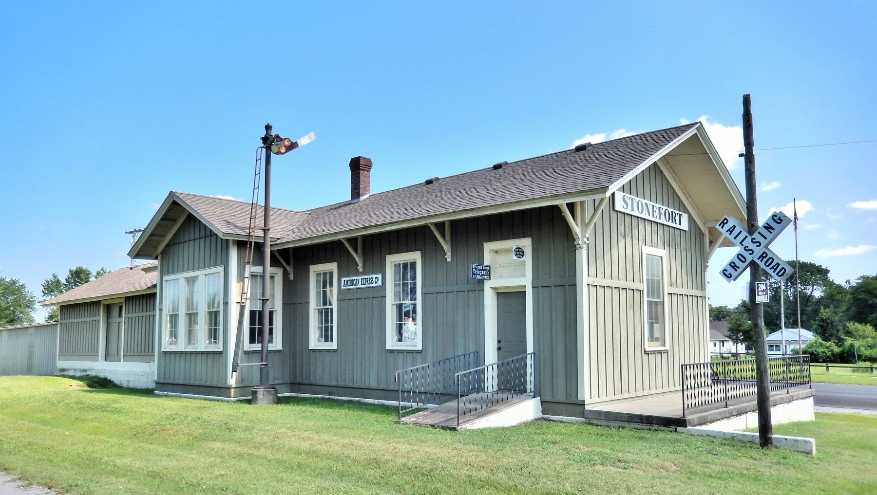
2. Stonefort Railroad Depot
The former Stonefort Depot is about 30 meters south of the historical marker and interpretive kiosk. It is on the opposite side of the rail trail (former railroad bed). Today the depot building houses a museum.
Parker Site
Parker was built at the intersection of the St. Louis, Alton, and Terra Haute RR and the Big Four RR. Hotels, dining rooms and barber shops thrived on business from salesmen traveling on trains. With the decline of rail traffic, Parker disappeared.
Tunnel Hill
Though not incorporated until 1873, buildings were erected in 1871 to house railroad workers who carved the 800-foot-long tunnel through shale and sandstone. Access to the railroad prompted farmers to plant crops of early apples for shipment north.
Sanburn Site
Sanburn was a construction camp for “gandy dancers” (track layers) for the Cairo-Vincennes RR. When the depot was built at Tunnel Hill, Sanburn became a flagstop.
Bloomfield
In the 1800s, Bloomfield made an unsuccessful bid to become the Johnson County seat. The town was mostly a stagecoach stop with one claim to fame: its tavern, unlike most, was a safe place to stay. In the 1870s the railroad gave Bloomfield a boost, but today just a few houses remain.
Vienna
Vienna didn’t officially exist when it was decreed the Johnson County seat in 1818. The post office opened in 1821, and the town was incorporated in 1837. By 1900 it had 1200 residents. Tragic fires in 1900 and 1936 and the Great Depression took their toll, but the town’s location near major highways and a state prison has helped it survive.
Trail of Tears
President Andrew Jackson signed the Removal Act in 1830. The U.S. government relocated the Five Civilized Tribes (Cherokee, Chickasaw, Creek, and Seminole) to Indian Territory in Oklahoma. Tens of thousands of Indians were force-marched along the Trail of Tears that passed through Vienna.
Bender Site
U.S. Highway 45 crosses the old railroad right-of-way at Bender. When occupied, the town had just one building. It served as housing and offices for railroad workers.
Forman Site
Forman had a large lumber mill in the 1870s. Eventually the timber ran out, but in 1910 when the new Chicago Burlington and Quincy RR was routed through Forman and crossed the Big Four, the town revived. The prosperity was short-lived, and Forman was almost deserted when a tornado finished it for good in 1957.
Belknap
Belknap incorporated in 1873. Prosperity came with the Cairo-Vincennes RR, and Belknap became a thriving town of some 800 people. But in the late 1800s, Belknap suffered economically from national crises and strikes, and when the new rail line bypassed it in 1910 and the highway was rerouted in 1918, the town declined.
Cache Town Site
Cache Town was established along the Cairo-Vincennes RR with a post office and nearby lumber mill. It survived only two years, probably a casualty of the five-year depression that began with bank failures in 1873.
Karnak
Shortly after the Cincinnati and Eastern Illinois RR and Big Four RR established a junction at the former sites of Cache Town and Oaktown, Main Brothers Box & Lumber Co. moved there (1905). The company platted a new town named Karnak around the mill that produced egg crates, containers, and cypress lumber.
Wetlands Center
The Henry N. Barkhausen Cache River Wetlands Center provides information and exhibits on IDNR's Cache River State Natural Area.
Rails to Trail
The transformation from rail line to bike trail began in 1989. Tracks and ties were removed leaving the railbed, bridges, trestles and historic Tunnel Hill tunnel. In 1991, 43 miles of railroad right-of-way were gifted to Illinois by the Norfolk Southern for the statewide Rails to Trails program. The first completed sections of the Tunnel Hill State Trail opened in 1998.
[photo captions]
• Clean clothes. Carrier Mills. January, 1939 [Arthur Rothsetine]
• The town of New Burnside isn’t the only thing named after Ambrose Burnside. The way the general wore his whiskers has given us the word burnsides, or sideburns. [Photo courtesy of Illinois State Historical Library]
• Tunnel at Tunnel Hill about 1910.
• Vienna Depot “Five O’Clock Train” about 1910.
• Belknap railroad crossing showing business district about 1912.
• Sanburn general store and post office.
Erected by Illinois Department of Natural Resources & Illinois State Museum.
Topics. This historical marker is listed in these topic lists: Industry & Commerce • Parks & Recreational Areas • Railroads & Streetcars • Settlements & Settlers.
Location. 37° 36.906′ N, 88° 42.478′ W. Marker is in Stonefort, Illinois, in Saline County. It is on Roosevelt Street just south of Stonefort Road (County Highway 16), on the left when traveling south. The marker is on the northeast side of the interpretive kiosk at the Tunnel Hill State Trail trailhead. Touch for map. Marker is at or near this postal address: 28 Chestnut Street, Stonefort IL 62987, United States of America. Touch for directions.

Regionally, this marker is in Southern Illinois — Little Egypt, in Shawnee Hills, and in the Tri-State Region. It is also in the American Midwest and in the Corn Belt. Globally, it is in North America, the Western Hemisphere, the Western World, and the Anglosphere. Historically, it finds itself in what was once the territory of the Mississippian Culture and also the Northwest Territory.
Other nearby markers. At least 8 other markers are within 7 miles of this marker, measured as the crow flies: Dedicated in Honor of Those Who Have Made the Supreme Sacrifice for Our Country (approx. 0.3 miles away); Revolutionary War Veterans (approx. 3.4 miles away); a different marker also named Tunnel Hill State Trail (approx. 4.3 miles away); World War II Memorial (approx. 6.3 miles away); Creal Springs (approx. 7 miles away); Carrier Mills Archaeological District (approx. 7 miles away); Veterans Memorial (approx. 7 miles away); Creal Springs Seminary (approx. 7.1 miles away).
More about this marker. There is an identical marker at the trailhead in New Burnside.
Also see . . . Tunnel Hill State Trail (Illinois Department of Natural Resources).
Excerpt: At one time, the rumble of freight cars reverberated through the narrow tunnel. Wooden trestles, with their system of slanted supports and horizontal cross pieces, spanned numerous bluffs and creeks. Passengers in Pullman cars clocked the miles with these and other landmarks as they traveled one of southern Illinois' most scenic routes.(Submitted on October 7, 2026, by Cosmos Mariner of Cape Canaveral, Florida.)
Tunnel Hill State Trail stretches for 45 miles from Harrisburg to Karnak. The trail continues on a trails spur for 2.5 miles from Karnak to Cache River State Natural Area - Henry Barkhausen Wetlands Center on the old Chicago and Eastern Illinois railroad bed.
The 9.3-mile section between Tunnel Hill and Vienna crosses trails already known to outdoor recreationists: the River-to-River Trails, which extends from the Mississippi to the Ohio River; the unmarked American Discovery Trails, which in southern Illinois follows back roads and some of the River-to-River Trail; the U.S. 76 Bicycle Route, a part of the TransAmerica Bike Route; and the Trail of Tears, the primary route the Cherokee Indian tribe took in the winter of 1838-39 during their forced move from the Great Smokies to Oklahoma.
Credits. This page was last revised on October 7, 2026. It was originally submitted on October 5, 2026, by Cosmos Mariner of Cape Canaveral, Florida. This page has been viewed 8 times since then. Photos: 1, 2. submitted on October 7, 2026, by Cosmos Mariner of Cape Canaveral, Florida.
Editor’s want-list for this marker. wide photo of the historical marker with context • Can you help?
