Near Rockerville in Pennington County, South Dakota — The American Midwest (Upper Plains)
"Great Unconformity" Geology
Photographed by William Fischer, Jr., September 21, 2026
1. "Great Unconformity" Geology Marker
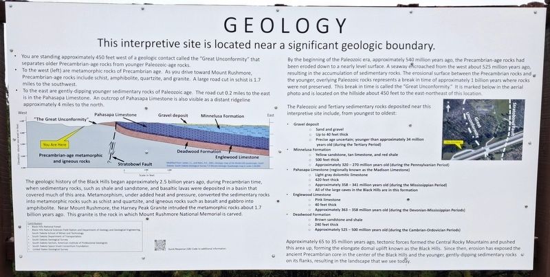
This interpretive site is located near a significant geologic boundary.
• You are standing approximately 450 feet west of a geologic contact called the "Great Unconformity" that separates older Precambrian-age rocks from younger Paleozoic-age rocks.
• To the west (left) are metamorphic rocks of Precambrian age. As you drive toward Mount Rushmore, Precambrian age rocks include schist, amphibolite, quartzite, and granite. A large road cut in schist is 1.7 miles to the southwest.
• To the east are gently-dipping younger sedimentary rocks of Paleozoic age. The road cut 0.2 miles to the east is in the Pahasapa Limestone. An outcrop of Pahasapa Limestone is also visible as a distant ridgeline approximately 4 miles to the north.
[Geologic cross-section illustrating the "Great Unconformity" with rock strata, running west to east]
Precambrian-age metamorphic and igneous rocks · "The Great Unconformity" · Deadwood Formation · Stratobowl Fault · Englewood Limestone · Pahasapa Limestone · Minnelusa Formation · Gravel deposit
————————————————————————————
The geologic history of the Black Hills began approximately 2.5 billion
this page online
By the beginning of the Paleozoic era, approximately 540 million years ago, the Precambrian-age rocks had been eroded down to a nearly level surface. A seaway encroached from the west about 525 million years ago, resulting in the accumulation of sedimentary rocks. The erosional surface between the Precambrian rocks and the younger, overlying Paleozoic rocks represents a break in time of approximately 1 billion years where rocks were not preserved. This break in time is called the "Great Unconformity." It is marked below in the aerial photo and is located on the hillside about 450 feet to the east-northeast
Photographed by William Fischer, Jr., September 21, 2026
2. "Great Unconformity" Geology Marker
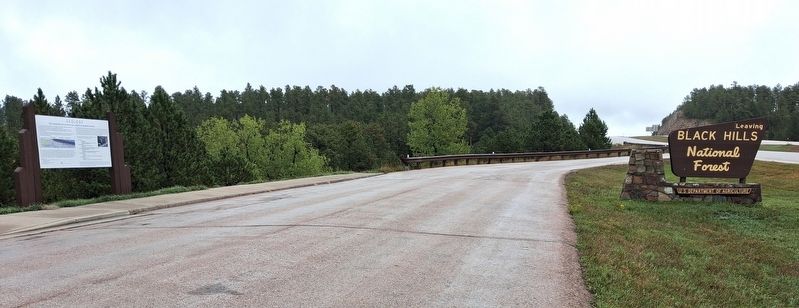
Looking ENE
The Paleozoic and Tertiary sedimentary rocks deposited near this interpretive site include, from youngest to oldest:
• Gravel deposit
Sand and gravel
Up to 40 feet thick
Precise age uncertain; younger than approximately 34 million years old (during the Tertiary Period)
• Minnelusa Formation
Yellow sandstone, tan limestone, and red shale
500 feet thick
Approximately 320-270 million years old (during the Pennsylvanian Period)
• Pahasapa Limestone (regionally known as the Madison Limestone)
Light gray dolomitic limestone
420 feet thick
Approximately 358-341 million years old (during the Mississippi Period)
All of the large caves in the Black Hills are in this formation
• Englewood Limestone
Pink limestone
40 feet thick
Approximately 363-358 million years old (during the Devonian Mississippi Periods)
• Deadwood Formation
Brown sandstone and shale
240 feet thick
Approximately 525-500 million years old (during the Cambrian Ordovician Periods)
Approximately 65 to 35 million years ago, tectonic forces formed the Central Rocky Mountains and pushed this area up, forming the elongate domal uplift
Photographed by William Fischer, Jr., September 21, 2026
3. Black Hills National Forest Sign
At Interpretive pullout
Erected by United States Forest Service and Related Contributors.
Topics. This historical marker is listed in these topic lists: Environment • Paleontology.
Location. 43° 58.061′ N, 103° 20.859′ W. Marker is near Rockerville, South Dakota, in Pennington County. It is on U.S. 16, on the right when traveling west. Marker pullout is about 7.5 miles southwest of the Rapid City junction of US Hwy 16 and the US Hwy 16 Truck Bypass. Touch for map. Marker is at or near this postal address: 13554 US Highway 16, Rapid City SD 57702, United States of America. Touch for directions.

Regionally, this marker is in West River, in the Badlands, and in Greater Rapid City. It is also in the American Black Hills, in the Lewis & Clark Corridor, on the prairies, and on the Northern Plains. Globally, it is in North America, the Western Hemisphere, the Western World, and the Anglosphere. Historically, it finds itself in what was once Rupert’s Land and also the Louisiana Purchase.
Other nearby markers. At least 8 other markers are within 6 miles of this marker, measured as the crow flies: Discover the Black Hills National Forest (a few steps from this marker); Explorer II (approx. 0.8 miles away); Wilderness (approx. 5.7 miles away); Black Elk Wilderness (approx. 5.7 miles away); Holy Terror Mine (approx. 6 miles away); Site of Ernest "Peg Leg" Haase Blacksmith Shop (approx. 6.1 miles away); Rune Stones (approx. 6.1 miles away); Keystone Trading Company/Halley's Store (approx. 6.1 miles away). Touch for a list and map of all markers in Rockerville.
Credits. This page was last revised on October 5, 2026. It was originally submitted on October 5, 2026, by William Fischer, Jr. of Reynoldsburg, Ohio. This page has been viewed 11 times since then. Photos: 1, 2, 3. submitted on October 5, 2026, by William Fischer, Jr. of Reynoldsburg, Ohio.
