Dinkelsbühl in Ansbach, Bavaria, Germany — Central Europe
Die Kriegsparteien formieren sich
1618–1623 Böhmisch-Pfälzer Krieg
⎯⎯⎯
The Warring Parties Take Shape
1618–1623 Bohemian–Palatine War
| — | 1619 | — |
Photographed by James Hulse, September 14, 2026
1. Die Kriegsparteien formieren sich / The Warring Parties Take Shape Marker

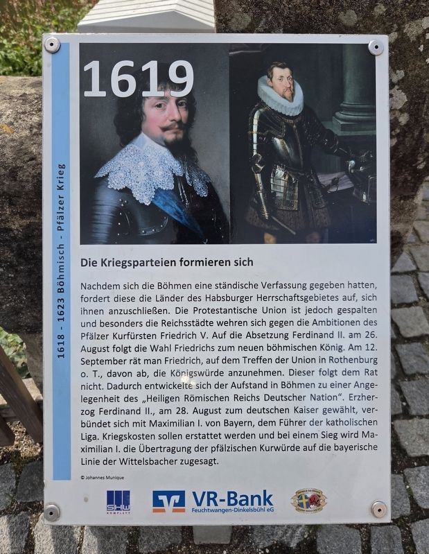
Nachdem sich die Böhmen eine ständische Verfassung gegeben hatten, fordert diese die Länder des Habsburger Herrschaftsgebietes auf, sich ihnen anzuschließen. Die Protestantische Union ist jedoch gespalten, und besonders die Reichsstädte wehren sich gegen die Ambitionen des Pfälzer Kurfürsten Friedrich V. Auf die Absetzung Ferdinands II. am 26. August folgt die Wahl Friedrichs zum neuen böhmischen König. Am 12. September rät man Friedrich auf dem Treffen der Union in Rothenburg ob der Tauber davon ab, die Königswürde anzunehmen. Dieser folgt dem Rat nicht.
Dadurch entwickelt sich der Aufstand in Böhmen zu einer Angelegenheit des „Heiligen Römischen Reichs Deutscher Nation“. Erzherzog Ferdinand II., am 28. August zum deutschen Kaiser gewählt, verbündet sich mit Maximilian I. von Bayern, dem Führer der katholischen Liga. Kriegskosten sollen erstattet werden, und bei einem Sieg wird Maximilian I. die Übertragung der pfälzischen Kurwürde auf die bayerische Linie der Wittelsbacher zugesagt.
© Johannes Munique
The Warring Parties Take Shape
After the Bohemians
this page online
The Bohemian uprising consequently became a matter concerning the “Holy Roman Empire of the German Nation.” Archduke Ferdinand II, elected Holy Roman Emperor on 28 August, allied himself with Maximilian I of Bavaria, leader of the Catholic League. Maximilian was promised reimbursement of his war expenses and, in the event of victory, the transfer of the Palatine electoral dignity to the Bavarian branch of the Wittelsbach dynasty.
Topics. This historical marker is listed in this topic list: Wars, Non-US.
Location. 49° 4.18′ N, 10° 19.309′ E. Marker is in Dinkelsbühl, Bayern (Bavaria), in Ansbach. It is
Photographed by James Hulse, September 14, 2026
2. Die Kriegsparteien formieren sich / The Warring Parties Take Shape Marker

Regionally, this marker is in German Franconia and on the Romantic Road. Globally, it is in Europe, the European Union, Atlantic Europe, Central Europe, the Schengen Area, Western Europe, and the Western World. Historically, it finds itself in what was once the Holy Roman Empire and also the former West Germany.
Other nearby markers. At least 8 other markers are within walking distance of this marker: Wörnitztor / Wörnitz Gate (within shouting distance of this marker); Schlacht am Weißen Berg bei Prag / Battle of White Mountain near Prague (within shouting distance of this marker); Heinz J. Ansbacher (within shouting distance of this marker); Prager Fenstersturz / The Defenestration of Prague (about 120 meters away, measured in a direct line); Ausgezehrt und ausgepresst / Exhausted and Drained (about 120 meters away); Stauferstele (about 150 meters away); Der Kaiser gewinnt an Boden / The Emperor Gains Ground
Photographed by James Hulse
3. Die Kriegsparteien formieren sich / The Warring Parties Take Shape Marker
Credits. This page was last revised on October 11, 2026. It was originally submitted on October 10, 2026, by James Hulse of Medina, Texas. This page has been viewed 2 times since then. Photos: 1, 2, 3. submitted on October 11, 2026, by James Hulse of Medina, Texas.
